This website uses cookies, which are small text files that the website puts on your device to facilitate operation. Cookies help us provide a better service to you. They are used to track general user traffic information and to help the website function properly.
Feature count in area: 15, all in Kerry,
OSI/LPS Maps: 70, EW-DC, EW-DW
Highest Place: Brandon 951.7m
Starting Places (18) in area Brandon Group: Ballinloghig, Ballybrack Mid, Brandon Pilgrimage Trail, Brandon Point, Brandon Village, Cloghane Community Centre, Conor Pass, Coosavuddig Quay Brandon Creek, Faha, Feoghanagh River, Hostel Cloghane Village, Lough Camclaun, Lough Doon CP, Mullaghveal Farm, Pedlars Lodge, Pilgrimage Trail Owenmore River, Sauce Creek Walkway Dingle Way, Tiduff
Summits & other features in area Brandon Group: Cen: Faha Ridge: Benagh 822.5m, Faha Ridge 809.2m N: Brandon Point: Faill an tSáis 430.7m N: Brandon Ridge North: Brandon Far North Top 840.1m, Brandon North Top 895.4m, Masatiompan 761.9m, Pierasmore North Top 700m, Pierasmore 745.7m S: Ballysitteragh: An Bhinn Dubh 479.2m, Ballysitteragh 623m, Beennabrack 608.5m S: Brandon Ridge South: Gearhane 803m, Brandon Peak 840m, Brandon 951.7m, Brandon South Top 790m
Note: this list of places may include island features such as summits, but not
islands as such.
Brandon Peak, 840mMountain Barr an Ghéaráin A name in Irish,
Place Rating ..
(Ir. Barr an Ghéaráin [OSI], 'top of the fang'), Géarán Mór, Kerry County in Munster province, in Arderin, Vandeleur-Lynam, Irish Best Hundred, Irish Highest Hundred Lists, Barr an Ghéaráin is the 25th highest place in Ireland.
Grid Reference Q47207 09481,
OS 1:50k mapsheet 70 Place visited by: 577members, recently by: davidrenshaw, DarrenY, knightsonhikes, Zenny, Glengirl, RosieMc, farmerjoe1, jackos, jellybean, Nomad691, Dee68, kelleher, rhw, MartMc, MeabhTiernan
I visited this place: NO (You need to be a logged-in member for this.)
Longitude: -10.236348, Latitude: 52.216359, Easting: 47207, Northing: 109481,
Prominence: 190m, Isolation: 0.8km ITM: 447190 609534 Bedrock type: Rhythmically bedded sandstone, (Ballymore Sandstone Formation) Notes on name: From the vicinity of Cloghane church there is a strange optical illusion whereby this peak seems higher than the summit, though it is actually over 100m lower.
Short or GPS IDs, 6 char: BrndPk, 10 char: BrndnPeak Linkback: https://mountainviews.ie/summit/24/
Gallery for Brandon Peak (Barr an Ghéaráin) and surrounds
Summary
for Brandon Peak (Barr an Ghéaráin):
A pointed summit on a grassy, well-defined ridge with extensive views.
Summary created by markmjcampion, Colin Murphy, Onzy
2023-08-17 11:32:24
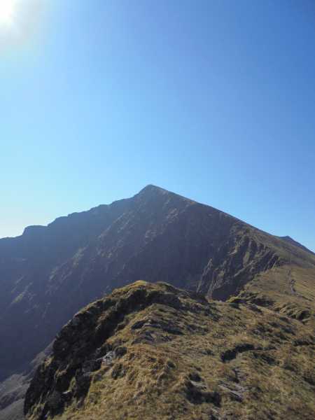
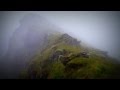
Picture: The peak as seen from the north
Brandon Peak is a spectacularly placed peak along the Brandon ridge. It’s surrounded by v steep ground on a 180 degree Eastern sweep so take care in bad weather. Grand views of nearby hills from Eagle to Beenoskee and further afield to Iveragh, Kerry Head and, at times, Loop Head.
The peak is usually reached in combination with others including Brandon, Brandon S. Top and Gearhane and possibly Masatiompan.
W. Park at Ballybrack BrDon PilTr (Q43380 09412) [large, busy car park] and ascend the gentle slopes and large crosses of the Saint’s Rd. Once you reach Brandon head SSE over its S top along a well-defined ridge before finally climbing steeply to reach the top of BP. [Allow 3 to 4 hrs]
NE. Park near Cloghane at (Q49383 11982) from where you have the choice of 2 paths; along a well-used track into the coomb NE of B. summit, or a higher, much trickier and exposed route over the Faha Ridge. When you top the ridge head S for B. and thereafter follow the ridge S for BP. {4 to 5 hrs]
NW. From Ballyknockane A (Q43340 12466) follow the Dingle Way which leads east to the col between Masatiompan and Piaras Mor and on to B. [4hrs+]
SW. For a great but long day out [2nd car needed], start at the Conor Pass and take in Beendubh, Beenabrack and Ballysitteragh before reaching Gearhane and BP.
WSW. Start at Ballinloghig from around B (Q42500 07709) (parking could be difficult) head over SH 404 and along airy ridge onto Gearhane.
Notable tracks incl. track/4249, track/3651 and track/4533
Onzy mentions the East Ridge of Brandon Peak, which is indeed a spectacular route, with more and better scrambling than the Faha Ridge. Had a great day on it in september. Park at the foot of the farm road at C (Q490 084), space for a couple of cars, maybe three. Follow the farm road and track up to a gate through the top fence just short of the loch. Go sharp right, through a bit of a boulder field until below the main shoulder coming down from the ridge, with Loch Cruttia down to your right. The foot of the ridge is in two buttresses, both nearly vertical at the bottom. Either go up the grassy gully in between them to join the RH buttress at a prominent wide crack, or get onto the LH buttress from either side and scramble up it (a bit vegetated), then once the angle eases off descend a steep sheep track rightwards to reach the same point. The crack is Moderate, and the L edge of the slab is the same grade. The whole lot is avoidable on the left. Lots more optional problems of any grade you like lead up to an easing of angle. The ridge then gets much narrower and more ridge-like, but also much easier. It's barely scrambling, but the big drop on the right gives some brilliant airy situations. It finishes bang on the summit cairn of Brandon Peak. A super way up the hill. Descending the East ridge of Gearhane takes you conveniently back to the start. Linkback: mountainviews.ie/summit/24/comment/18729/
Read Less
Read More
aidand on Brandon Peak
by aidand
9 Aug 2004
Climbed Brandon Peak recently as part of a ridge walk. We started at Faha near Cloghane, up the tourist route to Mount Brandon (took 2 hours). This is very well marked. From here follow a line of old fence posts and then a stone wall. This will bring you safley most of the way to Brandon Peak. In clear weather the views are excellent as described. From here it is a very clear ridge walk onto Gearhane. From here go through the gate. Follow the fence on your right for 3-400 yards. Then turn left and down to the farmhouse at Mullagh. This is the valley under the northside of the Connor Pass. It took us 5 hours to this point. Thankfully we had arranged to be collected here. Otherwise it is a 3 or 4 mile walk back on a tarred road to Cloghane and further again if you have to walk back to Faha.
This walk is definitely worth doing. I am already planning to do it by the reverse route and hopefully heading on from Mount Brandon to Pearasmore and down to Brandon Village. Linkback: mountainviews.ie/summit/24/comment/1072/
Read Less
Read More
csd on Brandon Peak
by csd
29 Jun 2003
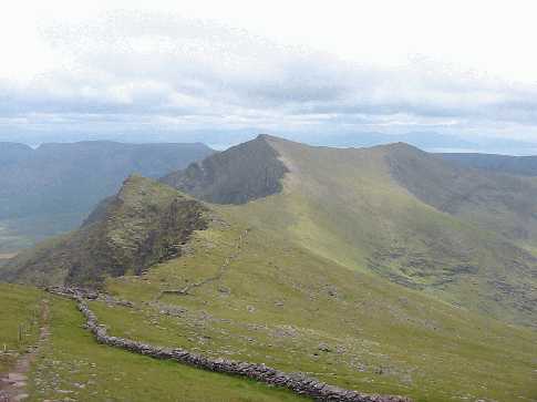
Photo shows the ridge walk over to Brandon Peak (centre), taken from the southern slopes of Mt Brandon itself. The wall makes navigating from Brandon to Brandon Peak trivial. Linkback: mountainviews.ie/summit/24/comment/570/
Read Less
Read More
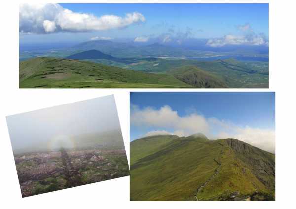
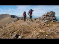
Picture: view form pass near Mullagheveal, path to top and Brocken spectre
from Mullaghveal to top and back
by marzka
29 Apr 2012
I was there in 2010.
Getting there: From Tralee , follow the N86 road, and then the R56 for Cloghane.. Just before village cross a bridge, pass the garda station on the right, and then cross another bridge and take the next left. Go to the end of the road. Start point is on the farm gate with climbing warning sign. Go through several gates and at the end keep the track on the right side. Walk up the track for a hundred metres. It is very wet on the pass, so going right to the top - keep going near the fence on the north.. go up to the gate, and then you'll find a good path to the top.
as everyone know the summit is frequently shrouded in clouds but it gives an opportunity to see the brocken spectre..
time: about 5 hours Linkback: mountainviews.ie/summit/24/comment/6787/
Use of MountainViews is governed by conditions and a privacy policy.
Read general information about the site. Opinions in material here are not necessarily endorsed by MountainViews.
Hillwalking is a risk sport. Information in comments, walks, shared GPS tracks or about starting places may
not be accurate for example as regards safety or access permission. You are responsible for your safety and your permission to walk.
See the credits and list definitions.


 Add a Place Comment for Brandon Peak, Barr an Ghéaráin


 Our Facebook page.