Donation Request 2024

DONATE
Members and Supporters, the MountainViews Committee requests your help to meet the costs of the website and of other activities such as insured events or publications.
You do not have to be logged in to donate.
Features
Nearby features appear when you click the map.
Declutter tracks on map.
Place Search
Video
X
Pub: by
Sperrin Mountains Area , NE Cen: Glenelly North East Subarea
Feature count in area: 64, by county: Derry: 34, Tyrone: 39, of which 9 are in both Derry and Tyrone, OSI/LPS Maps: 12, 13, 6, 7, 8
Highest Place: Sawel 678m

Starting Places (21) in area Sperrin Mountains:
Altinure Road, Banagher Glen Nature Reserve, Barnes Gap Car Park, Crocknakin, Drumnaspar Picnic CP, Glenchiel Road, Glenedra Bridge, Glenelly Road, Parkreagh, Goles Road, Lough Ouske, Moneyneany Village, Moydamlaght Forest, Moydamlaght Road, Mullaghmore, Mullaghbane, Spaltindoagh, Sperrin Hamlet, Sperrin Heritage Centre, Sperrin Heritage Centre W, Sperrin Road, Barnes Top, Sperrin Road, Glashagh Bridge, Sperrin Road, Sperrin

Summits & other features in area Sperrin Mountains:
E: Magherafelt Hills: Slieve Gallion NE Top 493.6m
E: Magherafelt Hills: Slieve Gallion 526.6m
N: Claudy Hills: Crockdooish 321m, Curradrolan Hill 270m, Eglish 277m, Letterlogher 249m, Mullaghmeash Hill 244m, Slieveboy 259m, Straid Hill 303m
NE Cen: Glenelly North East: Barnes Top 456m, Craigagh Hill 460m, Crockbrack 526.1m, Knockanbane Mountain 441m, Meenard Mountain 620m, Meenard Mtn W Top 480m, Mullaghaneany 627m, Mullaghash 480m, Mullaghsallagh 485m, Oughtmore 569m, Spelhoagh 568m
NE: Glenshane North: Benbradagh 465m, Boviel Top 454m, Carn Hill 448m, Carntogher 464m, Moneyoran Hill 414m
NE: Glenshane South: Bohilbreaga 478m, Coolnasillagh Mountain 423m, Corick Mountain 430m, Crockalougha 407m, Mullaghmore 550m, White Mountain 537m
NW Cen: Glenelly North West: Dart Mountain 619m, Dart Mountain North-West Top 525m, Learmount Mountain 489m, Learmount Mountain South Top 492m, Mullaghasturrakeen 581m, Mullaghcarbatagh 517m, Mullaghclogha 635m, Mullaghclogher 572m, Mullaghdoo 568m, Sawel 678m
NW: Maheramason Hills: Clondermot Hill 220m, Gortmonly Hill 218m, Slievekirk 370m
SE Cen: Glenelly South East: Carnanelly 562m, Carnanelly West Top 503.4m, Mullaghbane 467m, Mullaghturk 416m
SE: Cookstown Hills: Cregganconroe 300m, Fir Mountain 362m, Oughtmore 382m
SW Cen: Glenelly South West: Clogherny Top 408m, Craignamaddy 385m, Crocknamoghil 335m, Mullaghbolig 442m, Spaltindoagh 420m
SW: Mullaghcarn: Curraghchosaly Mountain 416m, Mullaghcarn 542m, Mullaghcarn South Top 525m
SW: Newtownstewart Hills: Bessy Bell 420m, Mullaghcroy 242m
W: Strabane: Balix Hill 403m, Knockavoe 296m, Owenreagh Hill 400m

Note: this list of places may include island features such as summits, but not islands as such.
Rating graphic.
Mullaghaneany, 627m Mountain Mullach an Ionaidh A name in Irish,
Place Rating ..
(Ir. poss. Mullach an Ionaidh [DUPN†], 'summit of the wonder'), Derry/ Tyrone County in Ulster province, in Arderin, Vandeleur-Lynam Lists, Mullaghaneany is the third highest mountain in the Sperrin Mountains area and the 246th highest in Ireland. Mullaghaneany is the second highest point in county Derry and also the third highest in Tyrone.
Grid Reference H68523 98619, OS 1:50k mapsheet 13
Place visited by: 173 members, recently by: rhw, Prem, Bob-the-juggler, ToughSoles, Tricia-Mulligan, Lgr, MickM45, Krzysztof_K, Paddym99, Sperrinwalker, garybuz, Cecil1976, Leonas_Escapades, Carolyn105, derekfanning
I visited this place: NO (You need to be a logged-in member for this.)
Longitude: -6.934824, Latitude: 54.830559, Easting: 268523, Northing: 398619, Prominence: 302m,  Isolation: 1.2km
ITM: 668438 898595
Bedrock type: Psammite & semipellite, (Dart Formation)
Notes on name: The OS Memoirs give two local versions of the name but state that the meaning is not understood.
  Short or GPS IDs, 6 char: Mlghnn, 10 char: Mlghnny

Linkback: https://mountainviews.ie/summit/234/
Gallery for Mullaghaneany (Mullach an Ionaidh) and surrounds
Summary for Mullaghaneany (Mullach an Ionaidh): Sperrin Sampler
Summary created by simon3, march-fixer 2012-10-01 17:57:47
            MountainViews.ie picture about Mullaghaneany (<em>Mullach an Ionaidh</em>)
Picture: Mullaghaneany from the west.
An easily accessible summit reached mostly from the Banagher Forest access track (just south of Altbritain Forest). This forest track starts at Glenedra Bridge (C7068 0028) on the B40 road just 100m NW of the Glenedra Bridge.

While the views from it are excellent, the summit itself lacks visual impact. The summit is quite flat and soggy as the ground here takes time to disperse the copious rainfall. There is a handy 'catching feature' of a fence that runs all the way over to Meenard. This mountain top has an elongated oval shape, lying in an SW-NE direction, and is the natural attack point on the way to Meenard from this direction, or as part of a horse-shoe circuit to Oughtmore and Craigagh Hill which should not take more than 5 hours.

Parking for possibly 2 cars beside the track entrance (soft verge) or for up to 3 cars at the quarry entrance 100m away SE towards Glenedra Bridge, provided you can pull up onto the rough grassy verge. Take care not to obstruct any gates.

Geology: The Sperrin Mountains are made up of schists and quartzites - metamorphic rocks which form an assemblage of ice-marginal morainic ridges and glaciofluvial terrace fragments that occurs in the rock cut col between the glacially eroded slopes of Mullaghmore and Mullaghaneany mountains.
Linkback: mountainviews.ie/summit/234/comment/4994/
Member Comments for Mullaghaneany (Mullach an Ionaidh)
Comment create / edit display placeholder

            MountainViews.ie picture about Mullaghaneany (<em>Mullach an Ionaidh</em>)
Goles Circuit
by gerrym 23 Jan 2014


http://youtu.be/k9qICH8gweQ for a visual record of the route from Banagher Forest

The great thing about the Sperrins is their accessibility and having initially used the walk guides I find that I can now spread out the OS map and plan a variety of routes with relative ease. There is a natural horseshoe around the Goles River valley which takes in the tops of Mullaghsallgh, Oughtmore, Mullaghaneany and Meenard and I thought I would give it a go.

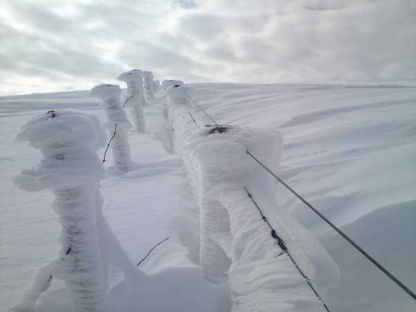
Tackled this one on Sunday 13th February which was quite a challenging day with gale force winds and low temps. Started at Goles Forest ( 
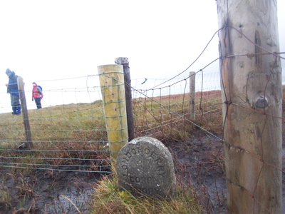
Crocknakin (H683 942)), turned right and walked along road for 5 minutes to reach a forest track on the left.

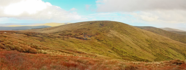
This climbs steeply uphill through clear fell, with great views across Goles Forest to the top of Carnanelly, aiming for the remaining high pine trees above. The track doglegs and then levels, with a clear swathe up through the trees on a carpet of green to reach open hillside. It is a short climb NE to reach Mullaghsallagh (485m). From here you get the chance to relish the remainder of the walk which is clearly visible.

Drop down N following the fence, crossing a very wet area that will have you hopping and turning for drier ground. When the fence turns off right towards Crockbrack continue straight, negotiating an extensive area of peat hags which were partly frozen. There is a short climb up to Oughtmore (569m) to pick up the fenceline running along it's lengthy top. The fence drops down to the col with Mullaghaneany where I tried to get some shelter for lunch - the fact that my hands took about 15 minutes to warm up after putting my gloves back on tells you I wasn't too successful.

The climb up Mullaghaneany is around 500ft and about 20 minutes. As with most of the Sperrins there is only a meeting of fences to distinguish the summit. Despite the northerly wind visibility wasn't great - I couldn't even see over to Donegal! Short drop down W and a long haul up and over Meenard, following the fence all the way - if want to reach top proper will have to detour off from fence to find the small cairn.

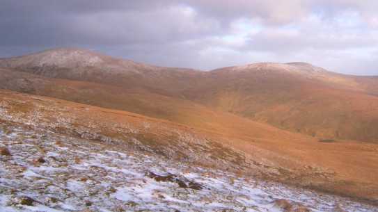
At W end of Meenard, Sawel and Dart were bathing in cold sunlight as I turned to follow the fence S along the shoulder of Meenard on the opposite side of Goles valley ( pic was taken here looking to Mullagheaneany on left and Oughtmore on right). The fence branches off regularly dowwn into the valley below, can take any of these to reach Goles river - there is a bridge just after the farm buildings.

Follow Goles road on its beautiful journey, passing abandoned farm buildings and with the river for company. Reach the B47 running the length of Glenelly valley, turn left and it is a short walk back to Goles forest and the car. A walk of just over 9 miles which took 5 hours. Linkback: mountainviews.ie/summit/234/comment/1487/
Read Less
Read More

            MountainViews.ie picture about Mullaghaneany (<em>Mullach an Ionaidh</em>)
eflanaga on Mullaghaneany
by eflanaga 9 Feb 2007
This walk commenced at the entrance to Altbritain Forest IA (C70607 00374) with the purpose of exploring a few of the Sperrin’s less visited 400+ metre hills. First up though was Mullaghaneany via Altbrittain forest track on a bright but frosty Sunday morning. The track, which is currently undergoing widening, makes for a reasonable easy start to the walk. Reaching the T-Junction after about 1.8K we turned left following the track the short distance to its end before working our way up Mullaghaneany’s fairly steep eastern flank onto its summit. The top, as with many in the Sperrins is fairly non-descript but the views, especially on the day in question, were quite spectacular in the early morning winter sunshine.. The stillness of the morning was evident from the reflection of the trees on the surface of Lough Fea some distance to the south-east. Despite all the recent wet weather the ground was holding up well, a fact I also noted on a sortie over Dart, Sawel and the High Sperrins a few weeks ago. From the summit our next target Meenard was clearly in view Linkback: mountainviews.ie/summit/234/comment/2607/
Read Less
Read More

            MountainViews.ie picture about Mullaghaneany (<em>Mullach an Ionaidh</em>)
Picture: Mullagheany to the right of Meenard
gerrym on Mullaghaneany
by gerrym 1 Oct 2006
(see Crockbrack and Meenard for first parts of this circuit). From summit of Meenard follow the ever present fenceline and drop down 300ft before the short climb to the summit of Mullaghaneany through the peat hags. The summit is marked by the joining of fencelines and the views as outlined on Meenard were perfect with clear air from the north. Taking in Oughtmore would have been a natural finish to the circuit but as was nearly dark i decided to follow fenceline northeast to the B40 running through Banagher Forest. With snow on the ground and a clear night sky there were even shadows on the ground, though with no torch I had to take it very easy and did find the going very difficult. This area is covered by three different OS maps so is a bit of a hassle. On reaching the road turn right (east) and follow as it drops down out of the hills, the road was covered in frozen snow and ice and again was difficult underfoot. With the clear night sky and isolation of walking along the road for 3 miles I had a fantastic experience with the parallel electricity pylons buzzing away to the side. At grid B (H738 984) turn left along the lane and left again to reach the carpark. ( 9 hours and 14 miles in all but could do quicker in better conditions and take in another 569m mountain). I have used the B40 through Banagher as a useful starting point for a number of climbs around Mullagheaney, Oughtmore and Meenard - there are several forest tracks which can be used as starting points, with parking and easy access onto the hills from a ready height. Linkback: mountainviews.ie/summit/234/comment/877/
Read Less
Read More

            MountainViews.ie picture about Mullaghaneany (<em>Mullach an Ionaidh</em>)
Picture: Mullaghaneany summit
Colin Murphy on Mullaghaneany
by Colin Murphy 20 Oct 2008
It seems the unrelenting rain of the summer has taken its toll on the Sperrins, which never seem to have had a chance to drain themselves. We did Mullaghaneany as part of a Meenard to Crockbrack loop and unfortunately it was a heavy slog through a sodden landscape of mud, long heather and even longer rushes. There was a nice feeling of wilderness here but be warned - bring your leggings and gaiters and maybe even your waders... The top of Mullaghaneany is marked only by adjoining fences, a weather-worn boundary stone and the carcase of a dead sheep lying in a pool of water! The nearest parking point we could identify is a spot to the south west of Meenard at Sperrin Road, Glashagh Bridge (H639 975). Linkback: mountainviews.ie/summit/234/comment/3395/
Read Less
Read More

            MountainViews.ie picture about Mullaghaneany (<em>Mullach an Ionaidh</em>)
Derry259 on Mullaghaneany
by Derry259 5 Mar 2010
Climbed Mullaghaneany on Sunday with Berghaus Phil,followed forestry track which begins 3 miles from Moneyneaney on the b40 road to Feeny.Follow the track for approximately 1and 1/2 miles ignoring one left fork after a mile.The track swings right and a fork appears,take the left fork for about 100meters where a large firebreak opens up on your right and slopes of Mullaghaneaney appear,start ascent climbing fence at forest line.As you move upwards pick up fence to right which leads to summit. On a clear day Mullaghaneaney offers stunning 360 degree views with Donard,Slemish ,Sawel and Errigal visible amongst many other summits.The views on Sunday whilst not as extensive were compensated for by the large snow drifts and beautiful cloud formations.A lovely walk which can be completed in less than 2 hours up and down or used as part of different circular walks as described by previous members....... Linkback: mountainviews.ie/summit/234/comment/4462/
Read Less
Read More
EDIT Point of Interest
text
Videos


Recent Contributions
x
Conditions and Info
Use of MountainViews is governed by conditions and a privacy policy.
Read general information about the site.
Opinions in material here are not necessarily endorsed by MountainViews.
Hillwalking is a risk sport. Information in comments, walks, shared GPS tracks or about starting places may not be accurate for example as regards safety or access permission. You are responsible for your safety and your permission to walk.
See the credits and list definitions.

OSi logo
OSNI/LPS logo
Open Street Map
(Various variations used.)
British summit data courtesy:
Database of British & Irish Hills