Members and Supporters, the MountainViews Committee requests your help to meet the costs of the website and of other activities such as insured events or publications.
Feature count in area: 65, all in Kerry,
OSI/LPS Maps: 78, 83, 84, 85, EW-KNP, EW-R
Highest Place: Stumpa Dúloigh 784m
Starting Places (66) in area Dunkerron Mountains: Ballaghasheen Coilte, Ballaghasheen Pass Viewpoint, Ballaghbeama Gap, Bohacullia, Bridia Valley End, Cahersavane Road, Cahersavane Schoolhouse, Cloon Lough NE, Cloon Lough SE, Coad Cemetery, Coad Road End, Com an Chiste, Coomaclarig Bridge, Coomnahorna River, Coomyanna Bridge, Dereenavurrig, Derreendarragh Church, Derrynane Quay, Dunkerron Mid, Eagles Lough Access Trailhead, Esknaloughoge Forest Trailhead, Fermoyle Farm, Foot Stick Ford Road, Gap of Dunloe Head of, Glashaknockbrassel Stream, Glasheenoultagh Stream, Gortaclohane Lane End, Gortaclohane Lane NE Branch, Gortagowan Wood, Gowlane School Ruin, Gowlanes Wood, Graces Landing, Inchimore West, Isknagahinney Lough E, Kenmare Bridge, Knockanamadane, Knockanaskill N, Knocknasullig, Knocknsallagh Bridge, Laghtacallow, Lissatinnig Bridge Boreen, Looscaunagh Lough W, Lough Barfinnihy CP, Lough Brin S, Lough Coomeen SE, Lough Dromtine NE, Lough Dromtine SE, Lough Fada N, Lough Iskanamacteery N, Lough Iskanamacteery NW, Lough Reagh N, Maghanlawaun Bridia Valley, Molls Gap, Ochtiabh Road, Poulacapple, River Owroe Source, River Sneem Fermoyle Loop, Rossacoosane Mid, Sahaleen Bridge, Scarriff Island, Shamrock Farmhouse B&B, Sneem, Tooreenboy Lough, Tooreennafersha Mid, Tooreennafersha South, Waterville Promenade
Summits & other features in area Dunkerron Mountains: Knocknagantee Near West Top 628m Cen: An Bheann Mhór: An Bheann Mhór 674.7m, An Bhinn Láir 514m, Coomcallee 648.9m, Beann na Stiocairí 673.1m, Coomnahorna 590m, Glanbeg 485.8m, Slievenashaska 578m, Slievenashaska South Top 565.4m Cen: Knocknagantee: Knockmoyle 682.1m, Finnararagh 667m, Cnoc Breasail 591m, Knocknagantee 674.3m, Knocknagantee West Top 553m, Coomnacronia 636m, Coomura Mountain 666m Cen: Mullaghanattin: An Cnoc Riabhach 534m, Beann 752m, Beann Far SW Top 636.2m, Beann NE Top 692m, Beann South Top 639m, Beann SW Top 657m, Sallagh 570m, Mullaghanattin 773m, Mullaghanattin East Top 594m, Sallagh South-West Top 543m E: Kenmare: Gortamullin 205m, Knockanaskill 356m, Letter South 362m N: Knocknacusha: Knocknacusha 547m NE: Knocknabreeda Ridge: Crossderry 489m, Knocknabreeda 569m, Mothaillín 506m NE: Knocknagapple: Bascadh 595m, Bascadh West Top 569m, Boughil 631m, Cnoc na gCapall 639m, Knocklomena 641m NE: Stumpa Dúloigh: Broaghnabinnia 745m, Knockaunanattin 569m, Knockaunanattin West Top 466.1m, Stumpa Dúloigh 784m, Stumpa Dúloigh SE Top 780m, Stumpa Dúloigh SW Top 663m SW: Caherdaniel: Farraniaragh Mountain 468m, Eagle Hill 155m, Reenearagh 162m, Beenarourke 304m, Knocknasullig 117m, Cahernageeha Mountain 498.7m SW: Coad ( Castle Cove ): Beenrour 418m, Eagles Hill 549m, Mullaghbeg 509m SW: Coomduff: Coomduff 244m SW: Deenish: Deenish Island (2) 144m SW: Esknaloughoge: Esknaloughoge 416m, Esknaloughoge North Top 420m SW: Scarriff: Scarriff Island 252m SW: Sneem: An Bheann Mhór 309.3m, Dereenavurrig Hill 261m, Knockanamadane 270m, Knocknafreaghane 316.5m, Knocknagullion 413m SW: Staigue: Staigue Top 459m, Staigue NE Top 435m
Note: this list of places may include island features such as summits, but not
islands as such.
Cnoc na gCapall, 639mMountain
Place Rating ..
(Ir. Cnoc na gCapall [OSI 1:25,000], 'hill of the horses'), Kerry County in Munster province, in Arderin, Vandeleur-Lynam Lists, Cnoc na gCapall is the 221st highest place in Ireland.
Grid Reference V83404 76730,
OS 1:50k mapsheet 78 Place visited by: 131members, recently by: rhw, knightsonhikes, maoris, ToughSoles, Krzysztof_K, jackos, Beti13, NualaB, Hjonna, Jimmy600leavey, tryfan, chelman7, Taisce, derekfanning, annem
I visited this place: NO (You need to be a logged-in member for this.)
Longitude: -9.695833, Latitude: 51.931006, Easting: 83404, Northing: 76730,
Prominence: 334m, Isolation: 0.8km ITM: 483379 576791 Bedrock type: Green sandstone & siltstone, (St. Finans Sandstone Formation) Notes on name: The first of three peaks on the ridge to the west of Boughil.
Short or GPS IDs, 6 char: CncngC, 10 char: CncngCpl Linkback: https://mountainviews.ie/summit/214/
Gallery for Cnoc na gCapall and surrounds
Summary
for Cnoc na gCapall :
Horses hill: Classic Kerry summit with views, wilderness and good environment.
Summary created by simon3, jackill
2012-11-01 18:04:45
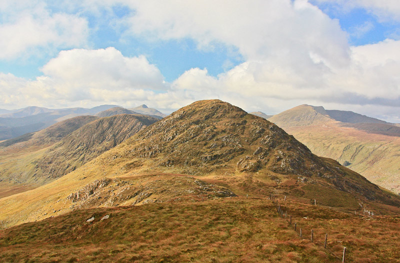
Picture: View from the E with the rest of the Boughils behind.
Park the car at Barfinnihy Lough where there is quite a large lay by A (V851 768), room for 10 cars.
Cross the fence at the northern end of the lough and climb up the steep, rocky mountainside handrailing a sheepwire fence to your left which runs all the way to the top of Boughil. The fence then continues on to Cnoc Na Capall
Alternatively, it is possible to start as described but skirt Boughil and go direct to the col between Boughil and Cnoc na gCapall and then straight up.
Walked this after 2 days of fairly intense rain, so it was slippery in spots, especially on the steeper parts, but the sheep fence is a constant companion all the way to from Boughil to the east to Bascadh to the west. Linkback: mountainviews.ie/summit/214/comment/15213/
Read Less
Read More
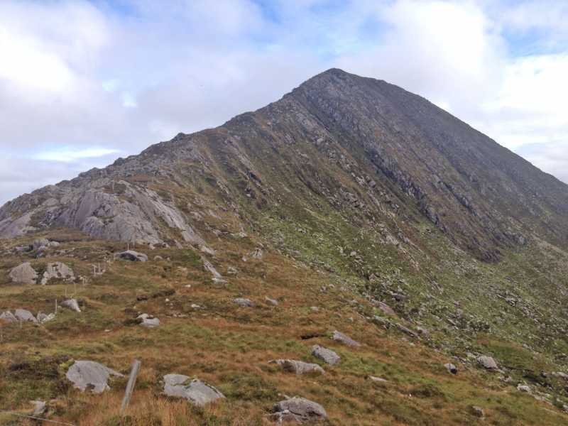
Picture: A view from just below summit of Bascadh
Tread carefully
by Onzy
22 Nov 2013
The descent west from Cnoc na gCapall and the subsequent ascent of Bascadh is over very confused terrain. While the fence is your handrail for the entire march over these tops, it will be necessary to depart a few metres from its comfort from time to time to avoid unfeasibly steep ground. This was particularly so today, a beautifully clear and sunny day, but very cold, with a lot of the rock carrying a slick coating of ice and a lot of the wet ground frozen. I found myself very wary of my footing particularly on the descent. Walk slowly and carry a big stick! Linkback: mountainviews.ie/summit/214/comment/15262/
Read Less
Read More
milo on Cnoc na gCapall
by milo
6 Jan 2004
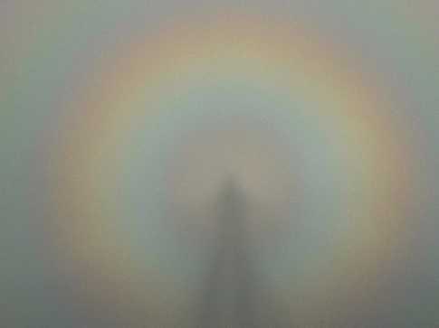
A substantial rise when approaced from the east (see photo.) Maimly memorable for the Brocken Spectre seen on 29th december '03 ( photo 2.) Linkback: mountainviews.ie/summit/214/comment/798/
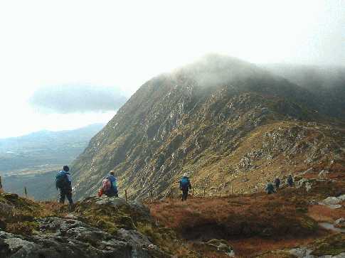
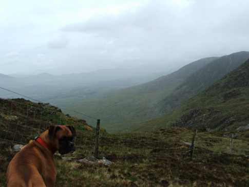
Pic of a view down the ridge. From the foreground, Cnoc na gCapall off frame to the right, Bascadh, then Knocklomena. Shown is my trusty navigator. Linkback: mountainviews.ie/summit/214/comment/1719/
Use of MountainViews is governed by conditions and a privacy policy.
Read general information about the site. Opinions in material here are not necessarily endorsed by MountainViews.
Hillwalking is a risk sport. Information in comments, walks, shared GPS tracks or about starting places may
not be accurate for example as regards safety or access permission. You are responsible for your safety and your permission to walk.
See the credits and list definitions.


 Our Facebook page.