Cookies.
This website uses cookies, which are small text files that the website puts on your device to facilitate operation. Cookies help us provide a better service to you. They are used to track general user traffic information and to help the website function properly.
Features
Nearby features appear when you click the map.
Declutter tracks on map.
Place Search
Video
X
Pub: by
Wicklow Area , NE: Fancy Subarea
Feature count in area: 115, by county: Wicklow: 108, Kildare: 4, Wexford: 2, Carlow: 3, of which 1 is in both Wexford and Wicklow, of which 1 is in both Carlow and Wicklow, OSI/LPS Maps: 28B, 55, 56, 61, 62, AWW, EW-DM, EW-LG, EW-WE, EW-WS
Highest Place: Lugnaquilla 924.7m

Starting Places (205) in area Wicklow:
1916 Memorial Car Park, Aghavannagh Ow Bridge, Aghowle Wood, Altidore Wood Entrance, Annacurra National School, Annalecka Bridge, Asbawn Brook L8350, Aughrim National School, Ballard Road, Ballinabarny Gap, Ballinagappoge Bridge Layby, Ballinagappoge Mountain Hairpin, Ballinagore, Ballinahinch Wood, Ballinastoe MBT CP, Ballinastraw South, Ballineddan Upr Fork, Ballinfoyle Upr Cross, Ballycoog, Ballycreen Brook Bridge, Ballycumber, Ballycumber Bridge, Ballycumber Lane, Ballycumber Wicklow Way, Ballylerane, Ballylow Bridge, Ballylusk Quarry, Ballymanus Lane, Ballymoyle Shooting Lodge, Ballynultagh Gap, Ballynultagh Lane, Ballyreagh Wood, Ballyross Forest, Ballysmuttan Long Stone, Baravore, Barnbawn South, Barranisky North, Barranisky West, Bohilla Land Roundabout, Bohilla Lane Mid, Boranaraltry Bridge, Bray Harbour, Brewel West, Brittas Bay North CP, Buckroney Sand Dunes CP, Bus Terminus, Camera Hill Track Cross, Castletimon Wood North, Clara Vale, Clone House Road, Clonegal, Cloon Wood Cp, Coate Bridge, Coolballintaggart Ledge, Coolbawn House Lane, Cransillagh Brook , Crone Wood CP, Crossbridge, Crossoona Rath, Cummer Wood South, Curtlestown Wood CP, Deputy's Pass CP, Derralossary Church, Derry River Bridge, Devil's Glen CP, Devil's Glen Wood, Djouce Wood Calary, Djouce Wood Lake, Djouce Wood Long Hill, Donard, Donnelly's Lane Car Sales, Drumgoff Forest, Dunranhill North, Dunranhill SE, Dunranhill South, Dwyer McAllister Cottage CP, Enniskerry, Fentons Pub, Fitzsimons Park GAA, unuseableFlemings Footbridge Glen Rd, Gap Pub, Gap Road, Glen Beach CP, Glen of the Downs CP, Glenbride Lane, Glenbride Lodge, Glencree Reconciliation, Glendalough, Glenealy GAA, Glenmacnass Tonelagee CP, Glenmalure Hostel, Glenmalure Lodge, Glenmalure Waterfall, Glenview Hotel, Gowle House, Great Sugar Loaf CP, Grove Bar, Heffernans Well Wood, Hill View, Hollywood Glen, JB Malone CP, Johnnie Fox Pub, Keadeen NE trail, Keadeen Trailhead, Kevins Way Footbridge, Kilbride Army Camp Entrance, Kilcandra South, Kilcommon View, Killalongford Wood, Kilmacrea Cross Roads, Kilranelagh House Gate, Kilruddery Car Park, Kilruddery Cottages, Kings River, Kippure Bridge, Kippure Estate, Kippure Transmitter Gate, Knickeen Cross, Knocknaboley Lane Leeraghs Bog, Knocknaboley Lane Stone Cottage, Knockrath Little, Knockree west, Kyle Loop North, Lackan Wood S, Lake Dr Fraughan Brook, Lake Drive, Lake Park Cross, Lake View Pub, Laragh Free Car Park, Laragh NSch, Lead Mines CP, Liffey Bridge, Liffey Head Bridge, Lough Bray Lower, Lough Bray Upper, Lough Tay North Viewing Point, Lough Tay Wicklow Way CP, Luglass Lane L97561, Lugnagun Track, Macreddin Village, Mangans Lane, Military Road Carrigshouk Hill, Military Road Inchavore River Nth, Military Road Inchavore River Sth, Military Road NW Lough Tay, Military Road Ballyboy Bridge, Military Road Cloghoge Brook, Military Road Croaghanmoira, Military Road Fananierin, Military Road LaraghWicklow Way, Military Road Slieve Maan, Monspolien Bridge, Moortown House, Mountain Rescue HQ, Muskeagh Little Wood, Nahanagan Lough NE, Novara Avenue, Bray, Oiltiagh Brook Knickeen, Old Bridge Cross, Old Bridge Scouts , Old Wicklow Way entrance, Paddock Hill SE, Pier Gates CP, Powerscourt Waterfall CP, Putland Road, Quintagh East, Raheen Park CP, Raheenleagh East, Railway Walk CP, Rathdrum Railway Station, Rednagh Wood, Rocky Valley, Roundwood, Sally Gap, Sally Gap N, Seefin Trailhead, Seskin SE, Shankill Tributary Bridge, Shay Elliott, Sheepshanks Bridge, Shillelagh, Slievecorragh Track, Slievefoore South, Sraghoe Brook, St John's Church, St Kevins Chair, St Kevins Church, St Kevins Way R756, Stone Circle Bridge, Stookeen South, Stranahely Wood, Stranakelly Cross Roads, Tallyho, Templeboden, Tithewer, Tomcoyle L, Tomriland Wood, Toor Brook, Trooperstown Hill Access, Turlough Hill CP, Upper Lake CP, Vallymount GAA CP, Vartry Reservoir Upper, Zellers Pub

Summits & other features in area Wicklow:
Cen: Glendalough North: Brockagh Mountain 556.9m, Brockagh Mountain NW Top 549.5m, Brockagh Mountain SE Top 471.7m, Camaderry East Top 677.3m, Camaderry Mountain 698.6m, Conavalla 734m, Tomaneena 682.4m
Cen: Glendalough South: Carriglineen Mountain 456.6m, Cullentragh Mountain 510m, Derrybawn Mountain 476.1m, Kirikee Mountain 474.5m, Lugduff 653.2m, Lugduff SE Top 638m, Mullacor 660.7m, Trooperstown Hill 430m
N Cen: Tonelagee: Carrignagunneen 561m, Fair Mountain 571.2m, Stoney Top 713.7m, Tonelagee 815.8m, Tonelagee E Top 668m, Tonelagee South-East Top 545.8m
NE: Bray & Kilmacanogue: Bray Head Hill 238.9m, Carrigoona Commons East 242m, Downs Hill 372.9m, Great Sugar Loaf 501.2m, Little Sugar Loaf 342.4m
NE: Djouce: Djouce 725.5m, Knockree 342.1m, Maulin 570m, Tonduff 642m, Tonduff East Top 593m, War Hill 684.8m, White Hill 631.1m
NE: Fancy: Ballinafunshoge 480m, Kanturk 527.4m, Knocknacloghoge 532.4m, Luggala 593.3m, Robber's Pass Hill 508.9m, Scarr 640m, Scarr North-West Top 559.8m, Sleamaine 430m
NE: Vartry: Ballinacorbeg 336m, Ballycurry 301m, Dunranhill 342m, Mount Kennedy 365.9m
NW: Blessington: Carrigleitrim 408m, Lugnagun 446.2m, Slieveroe 332m, Sorrel Hill 599.5m
NW: Mullaghcleevaun: Black Hill 602.2m, Carrigshouk 572.5m, Carrigvore 682.4m, Duff Hill 720.8m, Gravale 719m, Moanbane 703m, Mullaghcleevaun 846.7m, Mullaghcleevaun East Top 796m, Silsean 698m
S: Aughrim Hills: Cushbawn 400m, Killeagh 249m, Moneyteige North 427m, Preban Hill 389m
S: Croaghanmoira: Ballinacor Mountain 529.3m, Ballycurragh Hill 536m, Ballyteige 447m, Carrickashane Mountain 508m, Croaghanmoira 662.3m, Croaghanmoira North Top 579.5m, Fananierin 426m, Slieve Maan 547.8m, Slieve Maan North Top 546.1m
S: Croghan Kinsella: Annagh Hill 454m, Croghan Kinsella 606m, Croghan Kinsella East Top 562.1m, Slievefoore 414m
S: Shillelagh Hills: Lakeen 357m, Monaughrim 206m, Seskin 344m, Stookeen 420m
S: Tinahely Hills: Ballycumber Hill 429.7m, Eagle Hill 296m, Muskeagh Hill 398.2m
SE: Wicklow South East: Ballinastraw 284m, Ballyguile Hill 188m, Barranisky 280m, Carrick Mountain 381m, Collon Hill 238m, Kilnamanagh Hill 217m, Westaston Hill 270m
W: Baltinglass: Ballyhook Hill 288m, Baltinglass Hill 382m, Carrig Mountain 571m, Carrigeen Hill 298m, Cloghnagaune 385m, Corballis Hill 258m, Keadeen Mountain 653m, Spinans Hill 409m, Spinans Hill SE Top 400m, Tinoran Hill 312m
W: Cen Lugnaquilla: Ballineddan Mountain 652.3m, Benleagh 689m, Camenabologue 758m, Camenabologue SE Top 663m, Cloghernagh 800m, Corrigasleggaun 794.6m, Lugnaquilla 924.7m, Slievemaan 759.7m
W: Donard: Brewel Hill 222m, Church Mountain 544m, Corriebracks 531m, Lobawn 636m, Slievecorragh 418m, Sugarloaf 552m, Table Mountain 701.7m, Table Mountain West Top 563m

Note: this list of places may include island features such as summits, but not islands as such.
Rating graphic.
Scarr, 640.0m Mountain Scor A name in Irish,
Place Rating ..
(Ir. Sceir or Scor [PNCW], 'sharp rock'), Scard, Wicklow County in Leinster province, in Arderin, Vandeleur-Lynam Lists, Scarr is the 219th highest place in Ireland.
Grid Reference O13263 01883, OS 1:50k mapsheet 56
Place visited by: 829 members, recently by: rhw, KateLeckie, MartMc, Courin, MeabhTiernan, taramatthews, orlaithfitz, davidrenshaw, Prem, Lidia27, Magic, Carolineswalsh, Padraigin, ToughSoles, muddypaws
I visited this place: NO (You need to be a logged-in member for this.)
Longitude: -6.311527, Latitude: 53.055894, Easting: 313264, Northing: 201884, Prominence: 231m,  Isolation: 0.9km
ITM: 713187 701916
Bedrock type: Dark blue-grey slate, phyllite & schist, (Maulin Formation)
Notes on name: Formerly known as Knockree, according to Price.
  Short or GPS IDs, 6 char: Scarr, 10 char: Scarr

Linkback: https://mountainviews.ie/summit/210/
Gallery for Scarr (Scor) and surrounds
Summary for Scarr (Scor): Three ridges, many routes and good views.
Summary created by simon3 2018-11-19 20:01:36
            MountainViews.ie picture about Scarr (<em>Scor</em>)
Picture: Scarr from the SE.
Scarr has three useable ridges off it, to the north, south and east. The easiest perhaps is the Glenmacnass Waterfall carpark GlMacnas (O11380 03009) (notorious for break-ins). From here head for the north ridge that extends from Scarr to Kanturk (aka Brown Mountain). Round trip around 90-100 minutes.

Another starts from Oldbridge OldBge X (O1581 0197). From the east of the public road there is a well surfaced track that leads steadily uphill past farms and several new houses. Follow this until the point where it swings sharply left and leave it to head through a gateway straight ahead onto a grassy boreen that leads onto the lower slopes of Scarr.

From the south at LaraN (T14021 97510) there is a small carpark. (This is a useful also because there is a bridge allowing access to the Brockaghs area here) Head up via forest tracks and a path up the southern ridge of Scarr, marvelling that such a small summit can have so many false tops.

Other routes from the north come via Knocknacloghoge or the track around the north side of Lough Dan.

The top itself has a modest cairn. Notoriously Scarr can be extremely windy since its shape can catch a SW wind and funnel it towards the top.
Linkback: mountainviews.ie/summit/210/comment/4970/
Member Comments for Scarr (Scor)
Comment create / edit display placeholder

            MountainViews.ie picture about Scarr (<em>Scor</em>)
Picture: Arrowhead boulder on Kanturk
padodes on Scarr
by padodes 1 Jun 2008
A walk centred on Kanturk (close to Scarr) could begin at the forest entrance, Inch S (O106 055). Following the forest track to the end and through a curtain of trees, you meet the Inchavore River and walk downstream. Just where the valley broadens out, there’s a small coppice of native trees – among them several specimens of oak – that probably gives a good idea of the local woodland in the past, before the pine plantations came. On the flanks of Kanturk, to the right, can soon be seen the livid scar of a blocked-off mine shaft, similar to those in Glendalough and Glendasan. Further on, the crumbling ruins, close to where the road out of the valley begins, were perhaps also related to this activity, although the name of the area, Bolenasaggart, seems to point in another direction. This isn’t a bad place (A (O139 042)) to start climbing up to the right, the only climb of the walk and no more than 300m. It avoids a lot of the knee-high heather that is a feature of the gentler slopes further on. Among the knolls on top, there is a trodden path in places, but don’t count on keeping to it if the mist falls! At the western end, a track continues SW to the car park at Glenmacnass Waterfall, so at some point you will need to make your way NW, taking your bearings from Carrigshouk in the distance and aiming to meet the road around B (O103 044). You have to make your own track over this rolling but not unpleasant bogland, where turf cutting is still carried on in the traditional way. When you finally reach the Military Road, there remains a walk to the starting point, about one and a half kms away to the right. The circuit is no more than 11 kms. Kanturk may not be as airy as its close neighbour, Scarr, but it definitely has its own charms. Linkback: mountainviews.ie/summit/210/comment/3132/
Read Less
Read More

            MountainViews.ie picture about Scarr (<em>Scor</em>)
Picture: Cave entrance on Kanturk shoulder
aburden on Scarr
by aburden 5 Jan 2006
Great two car route for shaking off the cobwebs - meet at the finish which is commonly known as 'the piers' [C (O17200 06534)]. Drop one car here and drive on to the Start at [ OldBge X (O15786 01978)]. The route goes via Scarr and Kanturk before dropping down into the Inchavore Valley. If you aim to hit the valley at the end of the track running north east along Lough Dan - you may discover a cave which appears to be a disused mine [D (O13717 04214)]. The Copse in the vally makes an ideal lunch spot before crossing the river and an enjoyable walk along the lake. The last km or so is uphill on tarmac. Distance = 12.5km; time 5hr (incl. 30mins stops) Linkback: mountainviews.ie/summit/210/comment/2120/
Read Less
Read More

            MountainViews.ie picture about Scarr (<em>Scor</em>)
simon3 on Scarr
by simon3 20 Aug 2006
A popular route from Scarr is to head North-East towards Knocknacloghoge (534m) . In the way is the Inchavore River. You may have heard of a handy bridge crossing this. Don't believe it! On the occasion that I was there one Feb, it was extremely hard to cross the river, although we did manage near to the site of the bridge where there is a small island. It's at E (O124 044). Another option would be to walk upstream until the river narrows. It may be a long way. That's the near wilderness for you.
Update about bridge summer 2006. Apparently there is a bridge somewhere around there in place again. Linkback: mountainviews.ie/summit/210/comment/341/
Read Less
Read More

            MountainViews.ie picture about Scarr (<em>Scor</em>)
Picture: View from the eastern ridge
Small cairn, big views
by kernowclimber 31 Aug 2010
Leaving one car at Pier Gates, we drove to Oldbridge parking on a grassy verge ( OldBge X (O15823 01944)). Just ahead on the left is a well surfaced track that leads steadily uphill past farms and several new houses. Follow this until the point where it swings sharply left and leave it to head through a gateway straight ahead onto a grassy boreen that leads onto the lower slopes of Scarr. Just past an NPWS sign, follow a discernable track through the bracken on the far right close to the trees, at the top of which bear west over low gorse, heather and bilberry to meet with a ridge path up to Scarr.

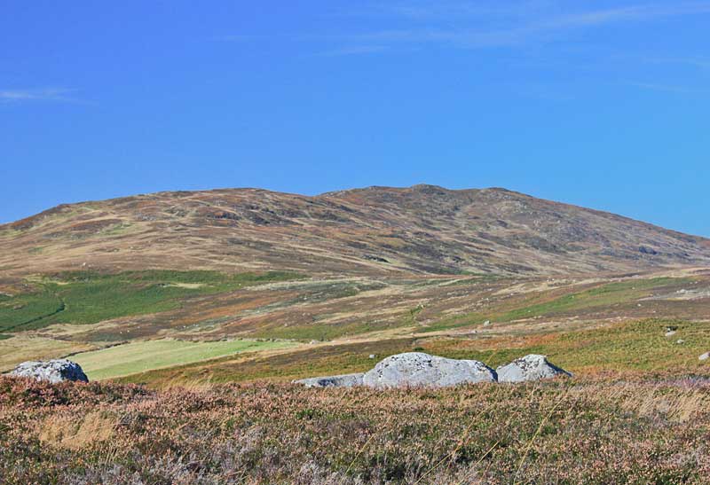
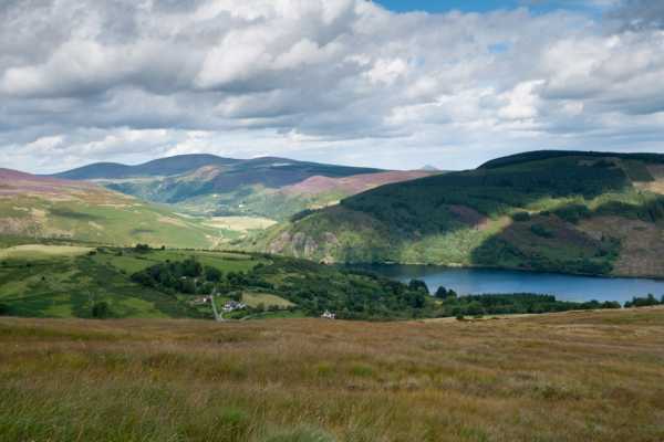
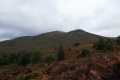
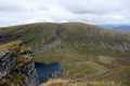
Dramatic vistas reward the walker from the ridge: Knocknacloghoge, the tumbled down rocks on its slope gleaming white in the sun, interspersed with beautiful swathes of golden gorse and purple heather mingling with the greens of bracken and conifer; in the valley below, Lough Dan, the wind creating continually changing mazy patterns over its inky blue surface, and on the skyline the gleaming quartzite peak of Great Sugar Loaf. The heightening wind sent clouds hurrying across the sky casting immense brooding shadows over the land whipping the ragged white heads of the nearby bog cotton into a frenzy.

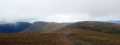
A steady climb over ground that is occasionally boggy and rocky in places brings one onto the grassy summit of Scarr with its small cairn and big views. Moorland undulates east towards the coast merging with deep green swathes of forestry and a colourful late summer patchwork quilt of fields, beyond which is the sea. And all around, wave upon wave of purple tainted mountains fade away into indigo, blue and smoky grey.

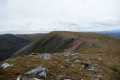
Descending in a NW direction provides fine views over Tonelagee, its slopes sweeping down to the Glenmacnass River flowing like quicksilver below. Close to the Old Military Road it cascades chaotically down over rocks to the glen below, its harsh cadence periodically audible before being snatched by the wind.

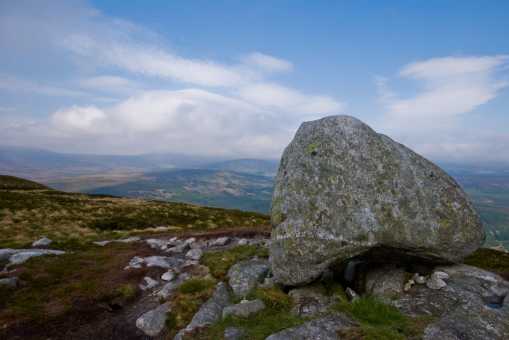
Our route over the heath to Kanturk offered exceptionally fine walking, passing by a phallic shaped rock at 
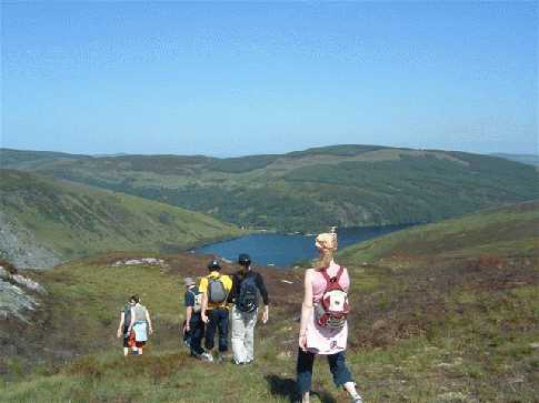
F (O12505 02798), bog pools and several glacial erratics like giants’ marbles accidentally dropped in a game eons ago. Grand views of Scarr lay behind us, rising skyward like a shark’s fin, and as we descended NE over short wiry heather, Lough Dan again came into view. On its NW shore is a sickle-shaped beach of golden sand deposited by the Inchavore River that meanders in serpentine fashion down the valley to empty into the lake close to a thin ribbon of trees.

Caution was needed as we made our descent over steep ground towards the Inchavore River; the heather and bracken is waist high in places and obscured rocks beneath. We soon came to a rocky pathway bounding forestry leading towards Lough Dan. A small cairn and a pile of stones on a rock outcrop on the path direct the walker down through the trees by a mossy wall (G (O13223 04310)) to gain a copse of oaks beside the river. Our next objective: Knocknacloghoge. Linkback: mountainviews.ie/summit/210/comment/6040/
Read Less
Read More

            MountainViews.ie picture about Scarr (<em>Scor</em>)
davekav on Scarr
by davekav 16 Jun 2003
From Scarr and along the ridge of Kanturk Hill is an excellant walk for introducing people to hill walking. When approaching from Roundwood, veer right at Oldbridge and park along the left hand side. Theres a small lane way on the left before the campsite. Take this to begin the ascent to Scarr itself. The ascent offers a slight challange, enough to give people the feel for hill walking. From the summit there are fine panoramic views, particularly of Glenmacnass, Tonelagee and back over towards Fancy and Djouce. You can then follow the ridge over Kanturk Mountain. As you follow this path you can see down into Glenmacnass Waterfall and as you begin the descent of Kanturk the views of Lough Dan are excellant. The final stage of the walk takes you along the road along the shore of the lake itself. All in all a not too taxing walk with excellant views that can be accomplished in around three and a half hours with time for lunch. Linkback: mountainviews.ie/summit/210/comment/549/
Read Less
Read More
EDIT Point of Interest
text
Videos


Recent Contributions
x
Conditions and Info
Use of MountainViews is governed by conditions and a privacy policy.
Read general information about the site.
Opinions in material here are not necessarily endorsed by MountainViews.
Hillwalking is a risk sport. Information in comments, walks, shared GPS tracks or about starting places may not be accurate for example as regards safety or access permission. You are responsible for your safety and your permission to walk.
See the credits and list definitions.

OSi logo
OSNI/LPS logo
Open Street Map
(Various variations used.)
British summit data courtesy:
Database of British & Irish Hills