Members and Supporters, the MountainViews Committee requests your help to meet the costs of the website and of other activities such as insured events or publications.
Feature count in area: 45, all in Donegal,
OSI/LPS Maps: 11, 6
Highest Place: Croaghgorm 674m
Starting Places (22) in area Bluestack Mountains: An Leathchruach, Barnsmore Gap, Bensons Hill, Caldragh CP, Clogher South peak, Cruach Mhín an Neanta, Doobin, Eanybeg Water Bridge, Edergole Farm, Gaugin Mountain, Glennacree CP, Hillhead, Lough Finn West, Lough Magrath Beg NE, Lough Muck North, Meenaguse Lough, Sand Lough Forest Picnic Area, Scoil Náisúnta an Choimín, Sheskinlubanagh, Sruell Gap Farm, Sruell River Road, St Columbkilles Well and Altar
Summits & other features in area Bluestack Mountains: Cen: Reelan Hills: Altnapaste 364m, Gaugin Mountain 565m, Lacroagh 403m, Boultypatrick 429m, Croveenananta 476m, Croaghubbrid 416m, Croaghugagh 410m N: Fintown Hills: Aghla Mountain South Top 589m, Aghla Mountain 593m, Scraigs 426m, Croaghleheen 385m NW: Glenties: Cloghercor South 301m, Derkbeg Hill 332m, Drumnalough Hill 282m S: Belshade: Croaghgorm 674m, Croaghgorm South-West Top 597m, Croaghgorm East Top 594m, Ardnageer 642m, Ardnageer SW Top 626m, Banagher Hill 392m, Croaghbane 641m, Croaghgorm Far South-West Top 561m, Cronamuck 444m, Croaghbarnes 498.8m, Glascarns Hill 578.3m, Meenanea 435m SE: Barnesmore: Brown's Hill 496.4m, Cloghervaddy 402m, Croaghagranagh 440m, Croaghanirwore 546.1m, Croaghbrack 401m, Croaghconnellagh 523m, Croaghnageer 569.1m, Croaghnageer East Top 543.5m, Croaghnageer North-East Top 521m, Croaghonagh 451m SW: Eany Beg Hills: Binbane 453m, Binbane NE Top 439m, Lavagh Beg 650m, Lavagh More 671m, Binnasruell 505m, Carnaween 521m, Cloghmeen Hill 429m, Silver Hill 600m, Cullaghacro 476m
Note: this list of places may include island features such as summits, but not
islands as such.
Croaghbane, 641mMountain An Chruach Bhán A name in Irish,
Place Rating ..
(prob. Ir. An Chruach Bhán [PDT], 'white stack'), Donegal County in Ulster province, in Arderin, Vandeleur-Lynam Lists, Croaghbane is the 216th highest place in Ireland.
Grid Reference G97853 91072,
OS 1:50k mapsheet 11 Place visited by: 152members, recently by: rhw, BarnabyNutt, abeach, gdg, orlaithfitz, Magic, mdehantschutter, ronanmckee, ToughSoles, Beti13, therealcrow, ochils_trekker, Krzysztof_K, Alanjm, JoHeaney
I visited this place: NO (You need to be a logged-in member for this.)
Longitude: -8.034108, Latitude: 54.767551, Easting: 197853, Northing: 391072,
Prominence: 76m, Isolation: 0.9km ITM: 597805 891063 Bedrock type: Main granite (adamellite), (Barnesmore Granite, G2 variety) Notes on name: Situated on the boundary of the townlands of Edergole, Cronakerny and Crolack. Name from J. Glover.
Short or GPS IDs, 6 char: Crghbn, 10 char: Croaghbane Linkback: https://mountainviews.ie/summit/209/
Gallery for Croaghbane (An Chruach Bhán) and surrounds
Summary
for Croaghbane (An Chruach Bhán):
Granite and Water
Summary created by Colin Murphy, CaptainVertigo
2014-03-28 20:46:05
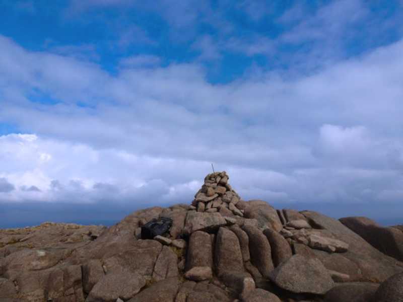
Picture: Croaghbane summit cairn
Turn south off the Ballybofey / Glenties road and enter the Reelan River Valley, where you will see a sign for Slí na Finne. Room for 6-8 cars at the Old School Clogher S (G95935 94116). There is an alternate parking spot just across the bridge for a couple of cars at G963 93. From there walk east a few metres and turn south descending towards the Reelan River along Sli na Finne. Cross the bridge and almost straight away turn east and follow the boggy wet track up to the ruined cottage, where you turn south and head up Glascarns Hill (from where there is a short hop to Croaghbane). Once a fence is crossed after the ruined cottage is left behind, the conditions underfoot improve and the main theme is rock - slabs and boulders. The incline is not particularly challenging and the views quickly open up in all directions, especially back to the north and to the east. Glascarns Hill is worth a stop, and in fact is just a couple of metres short of qualifying as an Arderin. Croaghbane itself has a broad summit full or boulders and rock. Lough Aduff can be very charming. Croaghbane is the ideal start point for the Bluestack 5 Arderins. Magnificient views. 1.5 hours car to top.
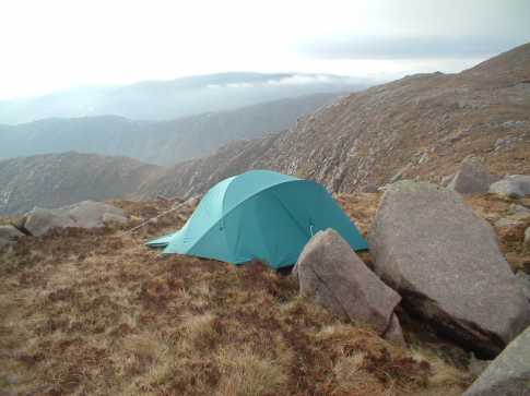
Climbed at the end of April as first mountain in Bluestack 5. Access from Glenties to Ballybofey road, at A (G967 964) turn off onto narrow road into Reelan Valley, follow for 1.5 miles to an old schoolhouse on right. This is a wild and rugged area with the Bluestacks laid out along the lenght of the valley. Park here and walk back a short distance to take lane downhill towards river and isolated farmhouse almost hidden by conifers. Turn left after crossing the river following waymarked posts. Start climbing after passing a ruined house up the slopes of Glascarns Hill (578m). The ground was very wet here and it was a job to try and pick out a drier route. I came to a new fence which was crossed by heading right to a metal farmgate. The ground then becomes rockier and levels out traversing an area of pools before climbing again to reach the summit of Glascarns after 1 h 45 mins. As it was late in the evening i pitched down here for the night (see pic) just above Cronloughan 1000ft below. I had an uncomfortable nights sleep as the temperature fell away (must get a better sleeping bag) but also a great feeling as probably the only person up in the hills. After packing up the next morning it was a short climb up to the summit of Croaghbane, with some great views down into the Owendoo River valley before entering the mist near the summit. Lough Aduff is just before the top and would have been a better spot to camp down. The summit cairn is just off to the west and i could see little in the mist. The mountain is nothing special to look at from this side but it is a good climb and there is good views on the way up, especially to the steep eastern side above Cronloughan. I am sure the view from the top on a clear day would be excellent. (See Ardnageer for continuation of the Bluestack 5 circuit). Climbed same route at start of Oct 2006 but a howling wind, horizontal rain stinging my face and mist made the going very unpleasant. Got to the summit but there was no way i was heading on towards Ardnageer. A compass bearing brought me back towards Glascairns Hill and as i dropped down below the mist i decided to head for the Effernagh river which would take me back near my starting point. The continuous rain was swelling the river and the surrounding ground was becoming increasingly wet. I am a bit of a sadist so part of me was enjoying the conditions but i was also feeling quite miserable slogging through the wet ground. Eventually skirted around the farm building and crossed the river back to the old schoolhouse. A companion had leaking boots and decided to leave them with another abandoned pair on a wall at the schoolhouse ( not very environmentally friendly but a shrine of sorts to the toll exerted by these hills) . Gettintg the waterproofs off and into the relative warmth of the car was a blessing. A completely different experience to my first time on this hill and a reminder of how much weather can alter the difficulty of hill walking. Linkback: mountainviews.ie/summit/209/comment/1011/
Read Less
Read More
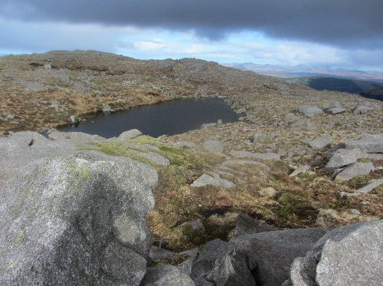
Picture: Lough Aduff from G98007 91048
Gateway to Bluestacks 5
by CaptainVertigo
23 Mar 2012
From Ballybofey or Glenties turn south at B (G96661 96279) and enter the Reelan River Valley. I passed the popular Old School parking spot at Clogher S (G95935 94116) (right) and continued a couple of kms to a junction at LeathCrua (G93721 93573) where there was room for one car carefully parked. This was because I intended to complete the Bluestacks 5 Arderins Summits beginning with Croaghbane and wanted to get the road walking out of the way. From the Old Schoolhouse walk east a few metres and turn south descending towards the Reelan River along Sli na Finne. Cross the bridge and almost straight away turn east and follow the boggy wet track up to the ruined cottage, where you turn south and head up Glascarns Hill - essentially the shoulder of Croaghbane. As you ascend you will see Gaugin Mountain behind you, its nether regions clothed in conifers but you will notice the large firebreak which is clearly a route to that summit. Soon you are walking mostly on light coloured granite slabs. There is an overwhelming sense of stone very much in the idiom of the Turks and even the Burren. To your right you can see the route to Ardnageer, Croaghgorm, and on to Lavaghs Mor and Beg. The next time I ascend Croaghbane I will want to hug the eastern rim of the route to Glascarns Hill so as to experience the exposure and magnificent views into the Owengarve and Owendoo Valleys. There's a short drop off Glascarns and then you confront the boulder field with the big soft Henry Moore scuptures. Watch for the characteristic colours of the Bluestacks...a soft sky blue mixing with rich warm tan browns. The summit is broad with more than one prominence. It is a riot of strewn rock with Lough Aduff providing a modest water feature. I abandoned the true summit and spent awhile lounging at the eastern tip at circa C (G98007 91048). Here the views are spectacular towards Gaugin, and round to Croaghbarnes. Way off north one can make out the Derryveaghs and Errigal. As I headed towards Ardnageer I felt I was now completely surrounded by rock, undulating, and slashed by large north south mini valleys. Looking south through one of these ridges I spied Lough Belshade. It sparkled in the early morning sunshine. The sense of isolation and tranquillity was inspiring. Stats: From the Reelan Bridge at 150m there is about 425m of ascent to Glascarns followed by a 50 m drop and another 50 m rise. Those continuing on towards Ardnageer and Croaghgorm have now completed most of the hard work. The next big pull will be Lavagh Mor. READING: I recommend Walk Guide -West of Ireland 3rd Edition Patrick Simms and Tony Whilde for the this particular route. It is also to be found in Paddy Dillon's The Mountains of Ireland but I personally cannot abide the half hearted "maps" in that particular book. TRACKS - See Track 1457 "in area near Croaghbane, Bluestack Mountains" Linkback: mountainviews.ie/summit/209/comment/6728/
Read Less
Read More
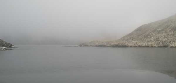
Picture: An icy Lough Belshade!
bryanmccabe on Croaghbane
by bryanmccabe
24 Feb 2010
A fabulously intricate climb with huge diversity of scenery and terrain over the 540m approx ascent to the summit. Parked on a cul de sac road in Edergole townland, at the northern end of Lough Eske (Edergole (G972 871)). At the end of the road there are some old farm buildings; you'll see a walker post signifying part of the old Ulster Way, turned offroad there and followed a zig zag path upwards to the Corabber River. The mist level was low (around 200m) and we either missed Eas Doonan waterfall or were very underwhelmed by it. Followed the river upstream for about 1km, before taking a right angle left turn to follow the same river up to Lough Belshade (312m). Only managed very brief glimpses of the steep walls surrounding the lake, mist was generally very heavy. Noticed what looked like a TV aeriel near the dam where the river flows from the lake (can anyone comment?). The silence was deafening, shattered only briefly by a text message from my mobile company advising me of charges now that I was roaming in the UK!! (The border with Co. Tyrone is not far away). Walked around the lake shore anticlockwise to the point (D (G978 897)) where a small stream flows down into the lake, and followed the stream upwards to the col marked 'Loughinisland' on OS Discovery Map. The path of this stream is actually the "oblique green line" identified in the picture posted by member "padodes" (see Ardnageer SW top). After a brief diversion to Croaghbarnes, returned to Loughinisland, followed a short ramp (WSW) and then an intricate sometimes rocky sometimes boggy route to the snow-clad summit of Croaghbane. It was difficult to identify the summit, but assumed it to be a small pile of stones marked by a small blue stick (like one you might buy in a garden centre to prop a shrub) presumably planted there by the local walking club (Ardnageer and Ardnageer South West top have these as well, Bluestack may have one also but couldn't find its summit with 20-30m visibility). Croaghbane is a hard earned 641m, would love to retrace the route on a clear day as the variety of the route is as impressive as any mountain I climbed to date. Linkback: mountainviews.ie/summit/209/comment/4439/
Read Less
Read More
Picture: Croaghbane in the early morning sunshine from Croaghbarnes summit
eflanaga on Croaghbane
by eflanaga
9 Jun 2006
Climbed June 8th - From my camp site just short of top of Croaghbarnes (See Croaghaniwore for previous stage of walk) I popped up onto the summit IG IE (G99061 90362) before making my way towards Croaghbane. From the top of Croaghbarnes the summits of many of the peaks around and about were visible while beneath them the countryside was enveloped in an early morning (07.00hrs) mist. From the top I took a bearing of 274 degrees W for about 700m so as to drop onto col/saddle IF (G98346 90297) in an area apparently named Loughinisland (my map is damaged on the seam at this point). This was in order to avoid the almost sheer drop into the Owendoo River valley running NE. From the saddle I took a bearing of 334 degrees NW climbing steeply up through boulder field (keeping to left for easier going) and up onto broad top with a number of heights vying for summit honours. I walked betwixt and between two in particular about 100m apart before finally plumping for the one to the NW with GPS reading of - IG (G97850 91070). Views of neighbouring peaks hampered only by the inversion phenomena, which in itself was something to behold!. From Croaghbane Ardnageer beckoned a relatively short distance to the SW. Linkback: mountainviews.ie/summit/209/comment/2385/
Read Less
Read More
padodes on Croaghbane
by padodes
26 Sep 2007
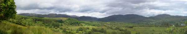
This is a panoramic view of the Bluestacks as seen from the eastern flank of Banagher Hill, directly south. It's hard to provide a single prominent point of reference in a whole range, but the higher part, just right of centre, would correspond to Croaghbane. The blue finger of water just about visible on the mid right is a corner of Lough Eske. Judging by the small number of people one finds walking in these beautiful mountains, they seem to be one of Donegal's best kept secrets. Linkback: mountainviews.ie/summit/209/comment/2839/
Use of MountainViews is governed by conditions and a privacy policy.
Read general information about the site. Opinions in material here are not necessarily endorsed by MountainViews.
Hillwalking is a risk sport. Information in comments, walks, shared GPS tracks or about starting places may
not be accurate for example as regards safety or access permission. You are responsible for your safety and your permission to walk.
See the credits and list definitions.


 Our Facebook page.