This website uses cookies, which are small text files that the website puts on your device to facilitate operation. Cookies help us provide a better service to you. They are used to track general user traffic information and to help the website function properly.
Feature count in area: 58, all in Down,
OSI/LPS Maps: 20, 29, EW-CLY
Highest Place: Slieve Donard 849m
Starting Places (33) in area Mourne Mountains: Alex Steddom Tree, Aughrim Airstrip, Ben Crom Dam, Bloody Bridge Car Park, Carlingford Greenway, Carrick Little, Crocknafeola Wood, Crotlieve Mountain, Donard Car Park Newcastle, Drummanmore Picnic, Fofanny Reservoir, Forest Office CP, Gamekeepers Lodge CP, Happy Valley Trassey Rd, Hen Mountain CP, Leitrim Lodge CP, Mayo Road Corner, Meelmore Lodge, Newcastle Harbour, Ott CP, Red Bog Road, Rourkes Park, Sandy Brae, Silent Valley Reservoir Head Rd, Slieve Donard Trail Head, Slieve Foye Viewing Point, Slievefoy Forest CP, Spelga Dam E, Spelga Dam N, Spelga Dam S, Trassey Car Park, Two Mile River CP, Yellow Water Park
Summits & other features in area Mourne Mountains: Cen: Loughshannagh: Ben Crom 526m, Carn Mountain 585.2m, Carn Mountain North Top 553.7m, Doan 592.6m, Ott Mountain 526.8m, Slieve Loughshannagh 617m, Slieve Muck 670.4m, Slievenaglogh 445m E: Binnian: Slieve Binnian 745.9m, Slieve Binnian East Top 639m, Slieve Binnian North Top 678m, Slieve Binnian North Tor 682.5m, Wee Binnian 460m E: Donard: Chimney Rock Mountain 656m, Crossone 540m, Millstone Mountain 460m, Rocky Mountain 524m, Slieve Donard 849m E: Lamagan: Cove Mountain 654.8m, Slieve Beg 595.9m, Slievelamagan 702.2m N: Bearnagh: Slieve Bearnagh 739m, Slieve Bearnagh North Tor 680m, Slieve Meelbeg 701.9m, Slieve Meelmore 687m N: Castlewellan: Slievenalargy 280m, Slievenaslat 272m N: Commedagh: Slieve Commedagh 767m, Slieve Corragh 641.9m, Slievenaglogh 584.4m, Slievenaglogh East Top 571m N: Croob: Cratlieve 429m, Slieve Croob 534m, Slievegarran 391m, Slievenisky 446m N: Rathfriland: Knockiveagh 235m S: Kilkeel: Knockchree 306m S: Rostrevor: Crenville 460m, Finlieve 578m, Slievemartin 485m, Slievemeel 420m, Slievemeen 472m W: Hilltown: Gruggandoo 382m, Slieveacarnane 296m W: Slievemoughanmore: Crotlieve Mountain 347m, Eagle Mountain 638m, Rocky Mountain 404m, Shanlieve 626m, Slievemoughanmore 560m, Tievedockaragh 473m, Wee Slievemoughan 428m W: Spelga: Butter Mountain 500m, Cock Mountain 504m, Cock Mountain South-West Top 505m, Hen Mountain 354m, Pigeon Rock Mountain 534m, Pigeon Rock Mountain South Top 530m, Slievenamiskan 444m
Note: this list of places may include island features such as summits, but not
islands as such.
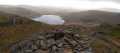
Slieve Binnian North Tor, 682.5mMountain Sliabh Binneáin (tor thuaidh) A name in Irish,
Place Rating ..
For origin of name, see Slieve Binnian., Down County in Ulster province, in Arderin Beg, Vandeleur-Lynam Lists, Slieve Binnian North Tor is the 137th highest place in Ireland.
Grid Reference J31968 24610,
OS 1:50k mapsheet 29 Place visited by: 521members, recently by: agakilbride, MeabhTiernan, benjimann9, eimirmaguire, Henning86, rhw, davidrenshaw, Prem, Magic, Carolineswalsh, Bob-the-juggler, BrianKennan, freelanb, Shaina, NualaB
I visited this place: NO (You need to be a logged-in member for this.)
Short or GPS IDs, 6 char: Slv683, 10 char: SlvBnnNrth Linkback: https://mountainviews.ie/summit/156/
Gallery for Slieve Binnian North Tor (Sliabh Binneáin (tor thuaidh)) and surrounds
Summary
for Slieve Binnian North Tor (Sliabh Binneáin (tor thuaidh)):
A fine rocky perch.
Summary created by simon3, Harry Goodman
2023-05-27 10:56:49
Picture: On top of the North Tor
Start at Carrick Little car park Carrick (J345 219) and follow the adjacent track N to cross a stone stile. Once over continue along the track as it swings NW to pass Annalong Wood and, some distance further along, the rocky hump of Percy Bysshe and the Blue Lough, both on the right side. Continue up and along the track to A (J321 256) in the col between Binnian and Lamigan. Turn left and go SW up a rocky edge. This rough track soon becomes a stone path, set down in 2011 to counter the erosion on the heather covered spur leading up towards the N Tor area B (J319 246).
Once there go in among the high rock tors and then seek to clamber up and around the right that is North side to gain the top. While not a difficult climb it could become so in high winds or icy conditions when it would best be avoided. The view from the top down N over the Ben Crom Reservoir is particularly fine, as is the 360 degree panorama of the high Mournes. Climb down carefully and return by way of acent to Carrick Little. An alternative route is to park at the Silent Valley car park C (J306 211) (for which there is a charge). Take the shuttle bus (a further charge), or walk, up the side of the Reservoir to the Ben Crom Reservoir BCrmDm (J315 255). Climb up the steps to the dam head and then take a rough track going NE up the hillside to the Binnian/Lamagan col A (J321 256). From here go up SE and follow the directions described above.
Hello Tsunami - although I've done the sevens a couple times just for my own peace of mind, I've never participated in the event proper. I have however seen it in “full” flow twice. On both occasions you could barely tell there were more people on the hill and these were only distinguishable from the rest of us by their drawn faces. I know where you’re coming from reference and inference damage, but I lean towards the view that there is a lot of hill out there and unless the world, its wife, 4 kids and a dog do a dragnet for a century or two over the entire surface, very little damage is done; after all, relatively speaking, man’s mark on the Mournes is akin to a grain of sand on a beach. Also if I might try to further put your mind at ease - anyone taking on the sevens is a fairly serious party and will not be leaving bottles of Buckie behind. Why not give it a go yourself first. Could I suggest a route? Carrick Little and main Annalong Track up to the foot of Commedagh; up Donard and back off on to Commedagh; along the ridge to Hares Gap and round the back to Meelmore, Meelbeg, down and on to Bearnagh; to the Brandy Pad and over Beg, Cove, Lamagan and lastly Binnian; and back into Carrick Little. It’s a tough old ask. Linkback: mountainviews.ie/summit/156/comment/1416/
Read Less
Read More
tsunami on Slieve Binnian North Tor
by tsunami
8 Jan 2005
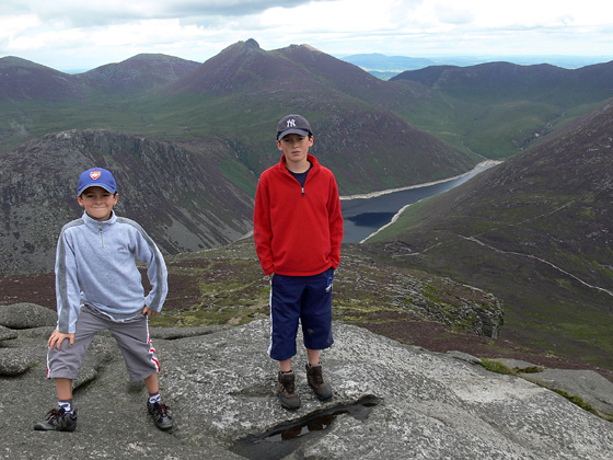
Here is a view of the North Tor on approach from Binnians Summit. I reached the summit following the wall from Carrick Little - easily the best route to tackle Binnian on. It's probably too hard to see after reduction for the web, but the little white dots to the left of it's base are actually a group of six men taking a well earned rest during the Mourne "Seven Seven's". I was happier to carry on at my leisure and spend some time exporing the summits - but some day I may be convinced to take part. My opinion at the moment though is that these type of events put a lot of unnecessary strain on the Mountain environment and need to continue to be very tightly run and regulated. If any one here does take part please correct me if things are not as bad as I make them out be. Linkback: mountainviews.ie/summit/156/comment/1411/
Read Less
Read More
tsunami on Slieve Binnian North Tor
by tsunami
8 Jan 2005
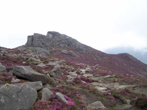
A closer view. You can scramble right to the top of this rock to get some fantastic views -unfortunately as the picture shows cloud cover was scuppering those plans this day. Linkback: mountainviews.ie/summit/156/comment/1412/
Read Less
Read More
tsunami on Slieve Binnian North Tor
by tsunami
11 Jan 2005
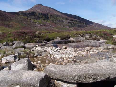
Following the Carrick Little track along the Annalong Valley, you catch this fine view of the NorthTor from the stream that Drains Binnian Lough. Binnian Lough is nestled between the North Tor and the Douglas Crag (the nearest cliffs immediately below the peak in the picture). Also in view to the right are the fine cliffs of the Blue Lough Butress and the Buzzards Roost (in the shadow along the horizon). Linkback: mountainviews.ie/summit/156/comment/1417/
Read Less
Read More
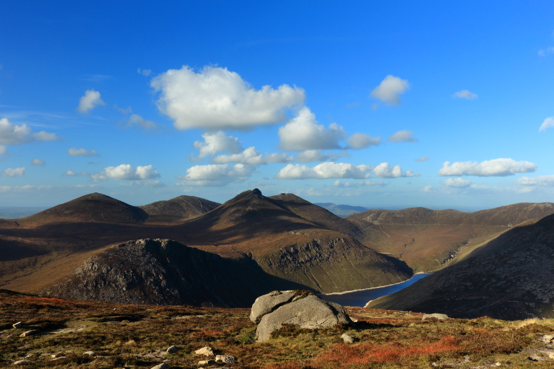
Picture: North over Ben Crom Reservoir to Slieve Bearnagh
Sculptural Summit
by Aidy
2 Oct 2014
Starting from Carrick Little, I had first visited Slieve Binnian, before heading for the North Tor, leaving the North Top and East Top for the way back. The Tor is very impressive, maybe even surpassing Binnian itself, and its well worth going for a climb over and around its surface if you can manage it safely. The photo was taken from the base of the Tor, looking north. Linkback: mountainviews.ie/summit/156/comment/17701/
Use of MountainViews is governed by conditions and a privacy policy.
Read general information about the site. Opinions in material here are not necessarily endorsed by MountainViews.
Hillwalking is a risk sport. Information in comments, walks, shared GPS tracks or about starting places may
not be accurate for example as regards safety or access permission. You are responsible for your safety and your permission to walk.
See the credits and list definitions.


 Our Facebook page.