This website uses cookies, which are small text files that the website puts on your device to facilitate operation. Cookies help us provide a better service to you. They are used to track general user traffic information and to help the website function properly.
Feature count in area: 59, all in Down,
OSI/LPS Maps: 20, 29, EW-CLY
Highest Place: Slieve Donard 849m
Starting Places (33) in area Mourne Mountains: Alex Steddom Tree, Aughrim Airstrip, Ben Crom Dam, Bloody Bridge Car Park, Carlingford Greenway, Carrick Little, Crocknafeola Wood, Crotlieve Mountain, Donard Car Park Newcastle, Drummanmore Picnic, Fofanny Reservoir, Forest Office CP, Gamekeepers Lodge CP, Happy Valley Trassey Rd, Hen Mountain CP, Leitrim Lodge CP, Mayo Road Corner, Meelmore Lodge, Newcastle Harbour, Ott CP, Red Bog Road, Rourkes Park, Sandy Brae, Silent Valley Reservoir Head Rd, Slieve Donard Trail Head, Slieve Foye Viewing Point, Slievefoy Forest CP, Spelga Dam E, Spelga Dam N, Spelga Dam S, Trassey Car Park, Two Mile River CP, Yellow Water Park
Summits & other features in area Mourne Mountains: Cen: Loughshannagh: Ben Crom 526m, Carn Mountain 585.2m, Carn Mountain North Top 553.7m, Doan 592.6m, Ott Mountain 526.8m, Slieve Loughshannagh 617m, Slieve Muck 670.4m, Slievenaglogh 445m E: Binnian: Slieve Binnian 745.9m, Slieve Binnian East Top 639m, Slieve Binnian North Top 678m, Slieve Binnian North Tor 682.5m, Wee Binnian 460m E: Donard: Chimney Rock Mountain 656m, Crossone 540m, Millstone Mountain 460m, Rocky Mountain 524m, Slieve Donard 849m E: Lamagan: Cove Mountain 654.8m, Slieve Beg 595.9m, Slievelamagan 702.2m N: Bearnagh: Slieve Bearnagh 739m, Slieve Bearnagh North Tor 680m, Slieve Meelbeg 701.9m, Slieve Meelmore 687m N: Castlewellan: Slievenaboley 324m, Slievenalargy 280m, Slievenaslat 272m N: Commedagh: Slieve Commedagh 767m, Slieve Corragh 641.9m, Slievenaglogh 584.4m, Slievenaglogh East Top 571m N: Croob: Cratlieve 429m, Slieve Croob 534m, Slievegarran 391m, Slievenisky 446m N: Rathfriland: Knockiveagh 235m S: Kilkeel: Knockchree 306m S: Rostrevor: Crenville 460m, Finlieve 578m, Slievemartin 485m, Slievemeel 420m, Slievemeen 472m W: Hilltown: Gruggandoo 382m, Slieveacarnane 296m W: Slievemoughanmore: Crotlieve Mountain 347m, Eagle Mountain 638m, Rocky Mountain 404m, Shanlieve 626m, Slievemoughanmore 560m, Tievedockaragh 473m, Wee Slievemoughan 428m W: Spelga: Butter Mountain 500m, Cock Mountain 504m, Cock Mountain South-West Top 505m, Hen Mountain 354m, Pigeon Rock Mountain 534m, Pigeon Rock Mountain South Top 530m, Slievenamiskan 444m
Note: this list of places may include island features such as summits, but not
islands as such.
Slieve Muck, 670.4mMountain Sliabh Muc A name in Irish,
Place Rating ..
(Ir. Sliabh Muc [PNNI], 'mountain of the pigs'), Down County in Ulster province, in Arderin, Vandeleur-Lynam, Irish Highest Hundred Lists, Slieve Muck is the 162nd highest place in Ireland.
Grid Reference J28109 24993,
OS 1:50k mapsheet 29 Place visited by: 505members, recently by: wintersmick, Gavsmi33, bowler, farmerjoe1, AlanReid, Henning86, knightsonhikes, Haulie, Muscles1960, benjimann9, Daingean, rhw, mlmoroneybb, Dee68, MeabhTiernan
I visited this place: NO (You need to be a logged-in member for this.)
Longitude: -6.039699, Latitude: 54.158002, Easting: 328109, Northing: 324994,
Prominence: 155.4m, Isolation: 1.2km, Has trig pillar
ITM: 728030 824999 Bedrock type: Sandstone, (Hawick Group) Notes on name: Overlooks the Spelga Dam and the Deer's Meadow, the source of the River Bann. It is surprising to think that this river rises less than 10 miles from the coast near Newcastle, and yet it empties into the sea near Coleraine.
Short or GPS IDs, 6 char: SlvMck, 10 char: SlvMuck Linkback: https://mountainviews.ie/summit/151/
Gallery for Slieve Muck (Sliabh Muc) and surrounds
Summary
for Slieve Muck (Sliabh Muc):
Southerly top of a fine spine in the central Mournes.
Summary created by markmjcampion, jackill
2023-05-10 12:31:28
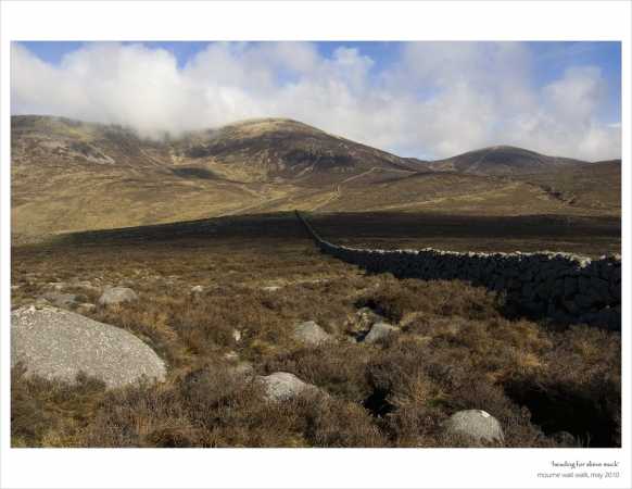
Picture: Slieve Muck from the SE
Slieve Muck is a broad, rocky hill to the west of the Silent Valley in county Down. Like a lot of the Mournes it has a network of high walls tracing across its upper slopes making for easy navigation. It's a good vantage point on a clear day to see much of the Mournes range incl. some of its fine valleys and reservoirs. Further afield lie the Cooley and Sperrin mts.
W. Park at SplgDmS (J27115 25243) where there is room for 5-6 cars. Cross the road and over the wall on the far side heading generally east then follow the stone wall uphill until it meets the main Mourne wall near the summit which is marked by a trig pillar. Allow 45mins
N. Park close to Ott CP (J28010 27857) and head for the NW spur of Ott mountain. From Ott head for the main wall on Carn Mt. N Top and follow this south to Muck passing Carn mt. en route. Best to leave Carn on the north side of the wall to avoid a potential impasse on its southern side at A (J28420 26005). Allow 2 hrs. Either retrace your steps or make your way down to the road on the western side and walk north back to the car.
S. Park at approx. Gmkeep (J28441 21414) and walk up the Banns Rd. to B (J29280 23750). Follow the wall NW from here for a little under 2km. The going is wet, steep and pathless in places but great views open up as you ascend. Allow 90 mins.
From this same parking spot you can also walk north about 1km up the B27 and ascend steeply via the S spur.
Notable tracks include track/4299 and track/4393 both of which can be easily adapted.
I Followed the Banns Road from the small car park at the start of this track, which is just past the Crocknafeola Wood on the Hilltown – Kilkeel road (Gmkeep (J284 214)). This leads into the mountains as far as Lough Shannagh. The Lough is an ideal spot to stop for a while to take in the surrounding mountains. At the north end of the Lough I headed towards the col between Slieve Loughshannagh and Carn Mountain. I then followed the Mourne Wall south over Carn to Slieve Muck. From the trig pillar at the top of Slieve Muck I went south along the ridge of the mountain to a small cairn near the end of the ridge before returning north again looking for a place to go down the steep escarpment that runs along the east side of the mountain. I found a place approx 100 m from the wall. The descent down S Muck is very steep and needs to taken extremely carefully; this is the only tricky part of the route. When it’s safe to do so head back towards the Mourne Wall and follow it down to the Banns Road track to return to the car park. This route took me around 6 hours but that was taking my time to with plenty of stops to take in the scenery. Linkback: mountainviews.ie/summit/151/comment/1033/
Read Less
Read More
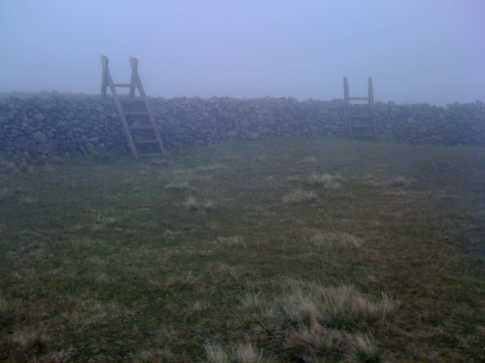
Picture: The stiles near the summit of Slieve Muck provide entertainment on a cloudy day.
wicklore on Slieve Muck
by wicklore
13 Oct 2008
I headed up Slieve Muck from the summit of Carn. It was simply a case of following the Mourne Wall, which was just as well due to dense cloud. I made the mistake of following the wall on the southern side from the summit of Carn, because when it went down into the col it soon came to a dead end at a wall of rock at C (J284 260). Clambering over the wall I was then able to skirt the rocky bluff and continued to follow the wall on its western side as it turned and headed up to the summit. It is less than a 100 metre climb over nearly 1km, but it was tiring after a long days walking. Sadly the cloud prevented any view from the summit, but I was impressed with the two stiles crossing the junction of the walls at the summit. Slieve Muck was to be the final summit of the day and so I descended NW across its steep slopes to meet the road at point D (J274 261). The going was slippy and boggy and required care. The clouds eventually gave way to views of Spelga dam and Butter Mountain. I was relieved to reach the road and a 2km calorie-burning march brought me back to the car at the Blue Quarry/Ott car park. The end of a long 7 hour hike, or was it? After Ott, Slieve Loughshannagh, Ben Crom, Doan, Carn and Muck I was tired, hot and footsore. Yet Butter Mountain beckoned, and I remembered an MV post suggesting it would only take 10 minutes…so I yielded to the temptation of this quick peak-bag. Linkback: mountainviews.ie/summit/151/comment/3386/
Read Less
Read More
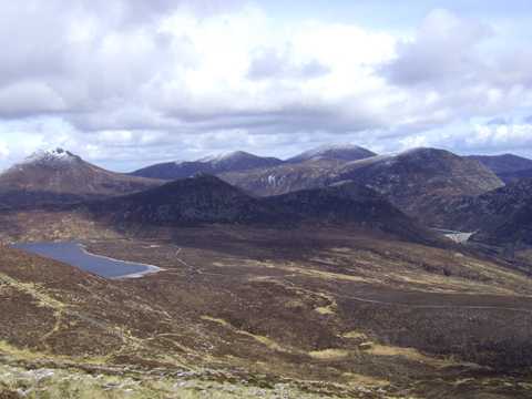
Picture: Approaching Muck from Slievenaglogh
It's all physiological
by paulocon
11 May 2010
Muck and myself have a history. Our first encounter came as part of a very enjoyable circuit of Spelga Dam, following Batts Wall to it's meeting point with the Mourne Wall. We had got on well that day, event taking some time to enjoy the views of the high Mournes and Spelga Dam.
Our second encounter came at the end of an ultimately doomed 2-day stint at walking the Mourne Wall, the day starting out in baking sunshine but ending up in a heavy mist stirred around Muck's slopes by a storm-force wind. Muck wasn't in a good mood and it was taking it out on us! Climbing muck as evening turned into night on that occassion, we had literally hit the wall... totally 'blown-up', our stuffed packs pulling us back one step for every two steps we took forward. At one stage, we even considered the possibility of pitching tents on a rock on the side of a relentlessly steep section of ground that just kept coming.
I had the second encounter in mind as I dropped off Slievenaglogh on a recent attempt at walking the Mourne Wall. Crossing Banns road, I could clearly see the sections on which we had struggled. This time however, Muck didn't put up anywhere near the same fight. Without the mist to hide it's tricky sections, it was a different beast altogether and taking a bit of time to pick a route away from the parts where the Wall gives way to crags, it's possible to have a relatively straightforward walk to the top. Linkback: mountainviews.ie/summit/151/comment/4715/
Read Less
Read More
Picture: Muck - the Spread
Bleck Cra on Slieve Muck
by Bleck Cra
20 Jun 2006
And so he broke the horizon with his jolly red face, less jolly but enthusiastic white legs and his effusive delight. “What about ye” I fished for a more sophisticated southern response. “Sure are the Mourne Mountains not great?” he beamed. Indeed “sure” they are: you would be addressing an evangelist of course. “And where have you come from today?” I enquired rather dully. “We came from Muckish and here we are now”. Indeed? From Muckish? “How long did that take you?”. “Oh it would be and hour and a half. An hour and a half now.” An hour and a half from Muckish. In County Donegal. And here you are at the top of Slieve Bearnagh, County Down. “Ah ye oul sausage and did you leave the Harrier parked or just hovering?” Well y’know I didn’t actually say it. Muck is in the Mournes and seemingly less dirty than Errigal’s neighbour which is only Muck-ish. I’ll leave it to a droid to fix my Irish, but we know all or some of it is to do with pigs. Muck is odd and final, careering in a lollop on to the Silent Valley Road and as such, ending the sway of the Eastern and more ostentatious Mournes. Momentum takes you up on to Pigeon and other fairly shameful indulgences. But stay a while on the Hill of the Pig and soak in the completely breathtaking panoramas it punts. From Slemish in Co Antrim across Lough Neagh to the confident tableau that is Meelbeg through Donard and back to Binnian. Yes all of them in one lash. Loughshannagh dessicating below and routes off at every point, to untrod tracks to be trod. I expect a tent and a primus would be a very good thing. Muckish as a dustbin lid. Enjoy. Linkback: mountainviews.ie/summit/151/comment/2411/
Read Less
Read More
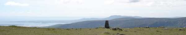
Picture: The view south from the summit area
csd on Slieve Muck
by csd
19 Jun 2005
We came up to the summit by following the wall from Carn Mountain. Today (19.06.2005) it was possible to see both Dublin and Belfast from the summit of Slieve Muck. The way down to Slievenaman Rd (to the west) is quite steep, so take care! Linkback: mountainviews.ie/summit/151/comment/1771/
Use of MountainViews is governed by conditions and a privacy policy.
Read general information about the site. Opinions in material here are not necessarily endorsed by MountainViews.
Hillwalking is a risk sport. Information in comments, walks, shared GPS tracks or about starting places may
not be accurate for example as regards safety or access permission. You are responsible for your safety and your permission to walk.
See the credits and list definitions.


 Add a Place Comment for Slieve Muck, Sliabh Muc


 Our Facebook page.