This website uses cookies, which are small text files that the website puts on your device to facilitate operation. Cookies help us provide a better service to you. They are used to track general user traffic information and to help the website function properly.
Starting Places (17) in area Gullion: Cadger's Bridge, Carrickbroad Road, Clermont Junction, Clermont Pass Bridge, Corrinshigo, Faughart Old Graveyard, Feede South, Flagstaff Viewing Point, Forkhill East, Longfield, Lower Faughil Road, Slieve Gullion Forest Drive, Slieve Gullion Viewing Platform, Slieve Gullion Viewing Platform N, Tamnaghbane Road, The Ben Rock, The Lumpers
Summits & other features in area Gullion: N: Gullion North: Carrigatuke 365m, Tullyhappy 209m SE: Ring of Gullion: Camlough Mountain 423m, Cotracloghy 225m, Croslieve 308m, Feede Mountain 233m, Foughill 241m, Hill of Faughart 113m, Mullaghbane Mountain 243m, Slieve Gullion 573m, Tievecrom 264m
Note: this list of places may include island features such as summits, but not
islands as such.
Hill of Faughart, 113mHill Focherd A name in Irish,
Place Rating ..
The Good Cast, Louth County in Leinster province, in Local/Historical/Cultural Lists, Hill of Faughart is the 1501th highest place in Ireland. Hill of Faughart is the most southerly summit in the Gullion area.
Grid Reference J05753 12652,
OS 1:50k mapsheet 29 & 36 Place visited by: 40members, recently by: TommyMc, cmcv10, Jai-mckinney, Oscar-mckinney, Dee68, Hoverla, trostanite, murphysw, garrettd, Kirsty, Carolyn105, dregishjake, Harry Goodman, dregish, briankelly
I visited this place: NO (You need to be a logged-in member for this.)
Notes on name: Getting it's name as gaeilge Focherd, meaning the good cast, from a feat that Cuchulainn performed during the Tain, where the legendary hero slew a number of his foes with one throw of his spear. It is also the birthplace of one of Ireland's three patron saints, Brigid. A well carrying her name is in the graveyard on the summit, as well as a medieval church (12th century), St Brigid's Pillar and St Brigid's Bed. The final resting place of Ireland's Last High King, Edward the Bruce (or most of him anyway). He had passed over the hill for the first time on the 29th June 1315 on his way to sacking Dundalk. He was killed here in battle on the 13th October 1318, he was beheaded on the stone of decapitation and his head sent back to the King of England. Standing at the southern end of the Gap of the North/Moyry Pass one of the five ancient roads to Tara runs past here and Faughart held huge strategic importance for many centuries and was the scene of much bloodshed in many battles. 8th century King Aedh Roin was beheaded here on the stone of decapitation. In 1593 Hugh O Neill & Hugh O Donnell (the two most powerful men in Ireland at the time) meet with Earl of Ormond at the hill. This meeting leads to the start of the nine years war, which in turn ultimately leads to the flight of the Earls and the plantation of Ulster! Lord Mountjoy taking control of this pass in 1600 greatly affected O'Neill during the war. King Billy passed over the hill on the 27th June 1690 on his way to the Boyne. The first body of one of the disappeared was returned at this hill, that of Eamonn Molloy on 25th May 1999. At the summit of the hill is the top of a large Norman Motte and Bailey, which was built over a much earlier earthworks
Short or GPS IDs, 6 char: HlofFg, 10 char: HlofFghrt Linkback: https://mountainviews.ie/summit/1499/
Gallery for Hill of Faughart (Focherd) and surrounds
Summary
for Hill of Faughart (Focherd):
Step back in time...
Summary created by Peter Walker
2016-02-28 21:08:29
Picture: The Hill of Faughart from the north-east
The Hill of Faughart is a geographically subdued eminence visible but not conspicuous from the dual carriageway just north of Dundalk, but it is well worth the short diversion on the drive north or south, blessed as it is by excellent views of upland, lowland and sea. Of even greater interest is its part in Irish history throughout the ages, a role excellently recounted in Trailtrekker's outstanding summit comment.
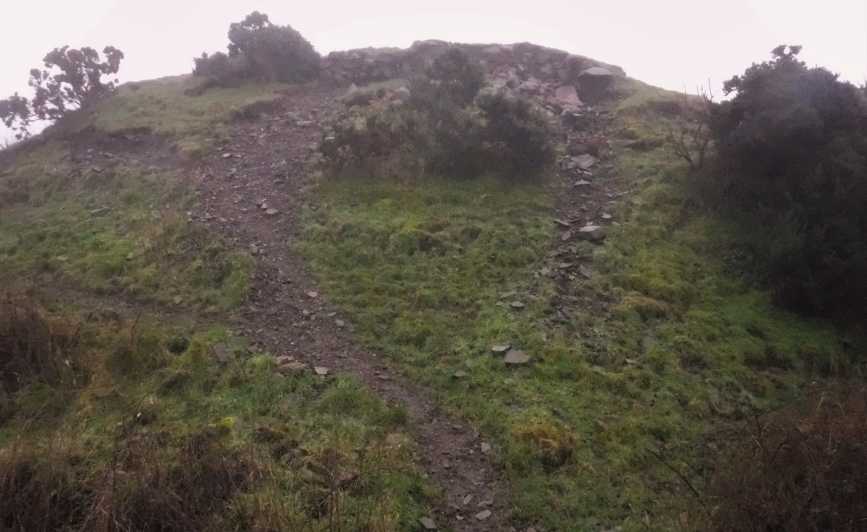
The actual top is the highest point of a Norman motte and bailey just off (and clearly visible from) the road running along the crest of the hill; this is on private land and whilst there is no signage discouraging walkers common sense is advised. To that end, it's best to leave the car in the parking area for the fascinating graveyard to the south-east (Faugh Gr (J059 125)) and then walk up the road to a gate directly below the top; climb over this and then clamber up a short slope of mud and stone to the highest point.
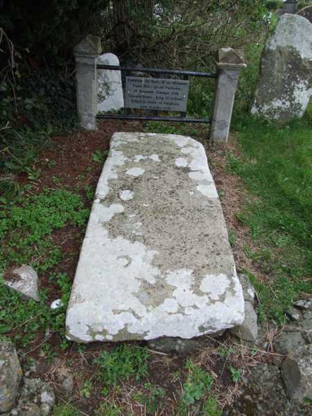
Picture: The Grave of the Last High King of Ireland
Birthplace of a Patron Saint & Resting Place of a High King
by Trailtrekker
28 Feb 2016
The summit of this hugely historical hill is the top of a large Norman Motte and Bailey, which was built over a much earlier earthworks . This is on private land off a narrow road, with the nearest parking back at the old graveyard. But it is back at the graveyard where you can view most of what this hill has to offer.
Getting its name as gaeilge "Focherd", meaning the good cast, from a feat that Cuchulainn performed during the Tain, where the legendary hero slew a number of his foes with one throw of his spear. It is also the birthplace of one of Ireland's three patron saints, Brigid. A well carrying her name is in the graveyard on the summit, as well as a medieval church (12th century), St Brigid's Pillar and St Brigid's Bed. It is the final resting place of Ireland's Last High King, Edward the Bruce (or most of him anyway). He had passed over the hill for the first time on the 29th June 1315 on his way to sacking Dundalk. He was killed here in battle on the 13th October 1318, he was beheaded on the stone of decapitation and his head sent back to the King of England. Standing at the southern end of the Gap of the North/Moyry Pass one of the five ancient roads to Tara runs past here and Faughart held huge strategic importance for many centuries and was the scene of much bloodshed in many battles. 8th century King Aedh Roin was beheaded here on the stone of decapitation. In 1593 Hugh O Neill & Hugh O Donnell (the two most powerful men in Ireland at the time) meet with Earl of Ormond at the hill. This meeting leads to the start of the nine years war, which in turn ultimately leads to the flight of the Earls and the plantation of Ulster! Lord Mountjoy taking control of this pass in 1600 greatly affected O'Neill during the war. King Billy passed over the hill on the 27th June 1690 on his way to the Boyne. The first body of one of the disappeared was returned at this hill, that of Eamonn Molloy on 25th May 1999.
The hills a bit quieter these days, well except maybe for the 1st February, St Brigids Feast Day, when you could possibly meet throngs of pilgrims, or school kids! Linkback: mountainviews.ie/summit/1499/comment/18411/
Use of MountainViews is governed by conditions and a privacy policy.
Read general information about the site. Opinions in material here are not necessarily endorsed by MountainViews.
Hillwalking is a risk sport. Information in comments, walks, shared GPS tracks or about starting places may
not be accurate for example as regards safety or access permission. You are responsible for your safety and your permission to walk.
See the credits and list definitions.


 Our Facebook page.