Cookies.
This website uses cookies, which are small text files that the website puts on your device to facilitate operation. Cookies help us provide a better service to you. They are used to track general user traffic information and to help the website function properly.
Features
Nearby features appear when you click the map.
Declutter tracks on map.
Place Search
Video
X
Pub: by
Belfast Hills Area , E: Belfast Hills East Subarea
Feature count in area: 9, by county: Down: 5, Antrim: 4, OSI/LPS Maps: 15, 20, 21
Highest Place: Divis 478m

Starting Places (2) in area Belfast Hills:
Ballyherly Lough West, Castlemahon Mountain South East

Summits & other features in area Belfast Hills:
E: Belfast Hills East: Cairngaver 217m, Ouley Hill 186m, Scrabo Hill 160m
N: Belfast Hills North: Carnmoney Hill 231.1m, Cave Hill 368m, Divis 478m, Slievetrue 312m
SE: Strangford & Portaferry: Ballywhite Hill 101m, Castlemahon Mountain 128m

Note: this list of places may include island features such as summits, but not islands as such.
Rating graphic.
Scrabo Hill, 160m Hill Screabach A name in Irish,
Place Rating ..
Ir. Screabach [PNNI 2], ‘thinly covered or stony ground’, Down County in Ulster province, in Local/Historical/Cultural Lists, Scrabo Hill is the 1458th highest place in Ireland.
Grid Reference J47756 72621, OS 1:50k mapsheet 15,21
Place visited by: 51 members, recently by: gerrym, Paddym99, garybuz, Combat_Monkey, eflanaga, paddyhillsbagger, sdmckee, Andy1287, Kirsty, Matrim, Vfslb1904, dregish, Carolyn105, PPruzina, Hoverla
I visited this place: NO (You need to be a logged-in member for this.)
Longitude: -5.715574, Latitude: 54.580252, Easting: 347756, Northing: 372621, Prominence: 97m,  Isolation: 4.6km
ITM: 747672 872616
Bedrock type: Sandstone
Notes on name: Scrabo Hill offers magnificent views of North Down, including Strangford Lough and the Ards Peninsula. It was long considered a fairy hill with its own fairy guardian named Mac an Eantoin. Scrabo Tower, designed by Sir Charles Lanyon, was built on the summit of the hill as a memorial to the third Marquis of Londonderry. With its turrets, it is prominent in views around Belfast and North Down. A hill-fort is situated on the top of this prominent hill and traces of a number of hut-groups can be seen below the summit (Archaeological Survey of County Down 147, 179). The quarries at Scrabo are amongst the most important in Ulster and are of considerable antiquity since Grey Abbey was built with Scrabo sandstone in the late 12th century. The Natural Stone Database (www.stonedatabase.com) lists no less than 109 historic buildings built with Scrabo sandstone, including Belfast Castle, Belfast Royal Academy and the Albert Clock.
  Short or GPS IDs, 6 char: ScrbHl, 10 char: Scrabo Hil

Linkback: https://mountainviews.ie/summit/1489/
Gallery for Scrabo Hill (Screabach) and surrounds
No summary yet for this place .
Member Comments for Scrabo Hill (Screabach)
Comment create / edit display placeholder

            MountainViews.ie picture about Scrabo Hill (<em>Screabach</em>)
Picture: Scrabo Tower at the summit
Towering views over north Down and beyond
by kernowclimber 6 Jul 2015
Scrabo Hill, an AONB, rises dramatically above the town of Newtownards and the surrounding plain. The view from the hill is exceptional, extending across Strangford Lough to the Mourne Mountains, the Isle of Man and the Scottish coast. It has been a place of human habitation from the Mesolithic through the Bronze and Iron Ages; the density and number of hut circles and the remains of an extensive hill fort indicate that it may have been one of the largest communal settlements in Ireland.

Scrabo is famous for its sandstone which has been exploited in a number of quarries designated an Area of Special Scientific Interest. The sandstone formed during the Triassic (160-190 million years ago), when this part of Ireland lay at the fringes of a vast desert; the climate was hot and punctuated by periods of torrential rain that caused severe erosion, depositing enormous quantities of sand in rivers and shallow lakes which later became rock. During the Tertiary, these sandstones were heated and intruded by a dolerite sill which formed a hard cap on the crag and tail of Scrabo Hill, protecting the sandstone from erosion, and scouring by later ice sheets.

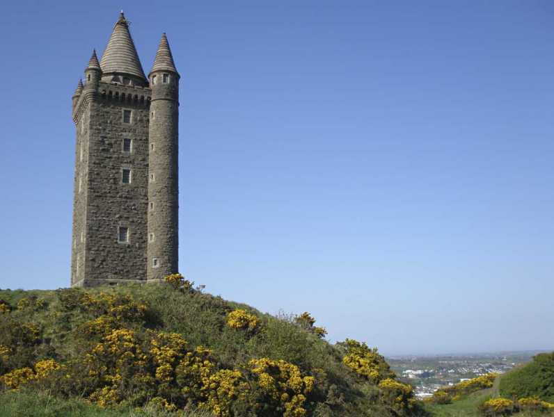
Today, the hill is part of the Scrabo Country Park and is marked by an iconic tower at its summit. Built to the design of Charles Lanyon and W H Lynn, and stylistically similar to a Scottish watch tower, it was erected in 1857 and financed by local people to commemorate Charles William Stewart, 3rd Marquis of Londonderry, as a mark of their gratitude for his efforts in alleviating poverty during the famine. Costing over £3,000, the tower is 41 metres high; its walls, over a metre thick, are constructed of Scrabo dolerite. The roof, stairs, quoins and window dressings are of Scrabo sandstone.

Lying unoccupied after the last tenants left in 1966, the tower deteriorated until the DoE (NI) undertook a programme of structural and remedial works. In 1983 it opened to the public during the summer months housing a centre for the Countryside and Wildlife Branch of the DoE and contained a permanent exhibition about the Country Park and the surrounding countryside. Visitors were able to climb the 122 steps to a viewing platform at the top of the tower for unsurpassed panoramic vistas. However, in April 2014 the tower was closed to the public on safety grounds following water damage to its electrical system.

From the Newtownards or the Comber bypass, follow the signs for Scrabo Country Park and drive uphill to its main car park. The summit can be reached in a few minutes by following a steep tarmac track uphill. Follow the 3.7 km circular route exploring the old sandstone quarries to lengthen your visit. Linkback: mountainviews.ie/summit/1489/comment/18172/
Read Less
Read More

Hill with a tower on top
by Wilderness 3 Sep 2018
The hill on its own is 160 meters high and the tower which sits on top of the hill is 40 meters high which will bring you up to 200 meters above sea level. The tower can be accessed and climbed during the spring and summer months from Thursday to Sunday. Entry into the tower was always free of charge but unfortunately that has now changed.

The hill can be climbed from the car park just below the Golf Clubhouse at A (J475 723) ; you do not have very much walking to do from here to the top.
If you want a longer walk , you can start at the Killynether forest car park which is lower down on the southwest side of the hill at: B (J473 719). The north and south quarries are also worth visiting ; especially the south quarry! Linkback: mountainviews.ie/summit/1489/comment/19898/
Read Less
Read More
EDIT Point of Interest
text
Videos


Recent Contributions
x
Conditions and Info
Use of MountainViews is governed by conditions and a privacy policy.
Read general information about the site.
Opinions in material here are not necessarily endorsed by MountainViews.
Hillwalking is a risk sport. Information in comments, walks, shared GPS tracks or about starting places may not be accurate for example as regards safety or access permission. You are responsible for your safety and your permission to walk.
See the credits and list definitions.

OSi logo
OSNI/LPS logo
Open Street Map
(Various variations used.)
British summit data courtesy:
Database of British & Irish Hills