This website uses cookies, which are small text files that the website puts on your device to facilitate operation. Cookies help us provide a better service to you. They are used to track general user traffic information and to help the website function properly.
Feature count in area: 65, all in Kerry,
OSI/LPS Maps: 78, 83, 84, 85, EW-KNP, EW-R
Highest Place: Stumpa Dúloigh 784m
Starting Places (66) in area Dunkerron Mountains: Ballaghasheen Coilte, Ballaghasheen Pass Viewpoint, Ballaghbeama Gap, Bohacullia, Bridia Valley End, Cahersavane Road, Cahersavane Schoolhouse, Cloon Lough NE, Cloon Lough SE, Coad Cemetery, Coad Road End, Com an Chiste, Coomaclarig Bridge, Coomnahorna River, Coomyanna Bridge, Dereenavurrig, Derreendarragh Church, Derrynane Quay, Dunkerron Mid, Eagles Lough Access Trailhead, Esknaloughoge Forest Trailhead, Fermoyle Farm, Foot Stick Ford Road, Gap of Dunloe Head of, Glashaknockbrassel Stream, Glasheenoultagh Stream, Gortaclohane Lane End, Gortaclohane Lane NE Branch, Gortagowan Wood, Gowlane School Ruin, Gowlanes Wood, Graces Landing, Inchimore West, Isknagahinney Lough E, Kenmare Bridge, Knockanamadane, Knockanaskill N, Knocknasullig, Knocknsallagh Bridge, Laghtacallow, Lissatinnig Bridge Boreen, Looscaunagh Lough W, Lough Barfinnihy CP, Lough Brin S, Lough Coomeen SE, Lough Dromtine NE, Lough Dromtine SE, Lough Fada N, Lough Iskanamacteery N, Lough Iskanamacteery NW, Lough Reagh N, Maghanlawaun Bridia Valley, Molls Gap, Ochtiabh Road, Poulacapple, River Owroe Source, River Sneem Fermoyle Loop, Rossacoosane Mid, Sahaleen Bridge, Scarriff Island, Shamrock Farmhouse B&B, Sneem, Tooreenboy Lough, Tooreennafersha Mid, Tooreennafersha South, Waterville Promenade
Summits & other features in area Dunkerron Mountains: Knocknagantee Near West Top 628m Cen: An Bheann Mhór: An Bheann Mhór 674.7m, An Bhinn Láir 514m, Coomcallee 648.9m, Beann na Stiocairí 673.1m, Coomnahorna 590m, Glanbeg 485.8m, Slievenashaska 578m, Slievenashaska South Top 565.4m Cen: Knocknagantee: Knockmoyle 682.1m, Finnararagh 667m, Cnoc Breasail 591m, Knocknagantee 674.3m, Knocknagantee West Top 553m, Coomnacronia 636m, Coomura Mountain 666m Cen: Mullaghanattin: An Cnoc Riabhach 534m, Beann 752m, Beann Far SW Top 636.2m, Beann NE Top 692m, Beann South Top 639m, Beann SW Top 657m, Sallagh 570m, Mullaghanattin 773m, Mullaghanattin East Top 594m, Sallagh South-West Top 543m E: Kenmare: Gortamullin 205m, Knockanaskill 356m, Letter South 362m N: Knocknacusha: Knocknacusha 547m NE: Knocknabreeda Ridge: Crossderry 489m, Knocknabreeda 569m, Mothaillín 506m NE: Knocknagapple: Bascadh 595m, Bascadh West Top 569m, Boughil 631m, Cnoc na gCapall 639m, Knocklomena 641m NE: Stumpa Dúloigh: Broaghnabinnia 745m, Knockaunanattin 569m, Knockaunanattin West Top 466.1m, Stumpa Dúloigh 784m, Stumpa Dúloigh SE Top 780m, Stumpa Dúloigh SW Top 663m SW: Caherdaniel: Farraniaragh Mountain 468m, Eagle Hill 155m, Reenearagh 162m, Beenarourke 304m, Knocknasullig 117m, Cahernageeha Mountain 498.7m SW: Coad ( Castle Cove ): Beenrour 418m, Eagles Hill 549m, Mullaghbeg 509m SW: Coomduff: Coomduff 244m SW: Deenish: Deenish Island (2) 144m SW: Esknaloughoge: Esknaloughoge 416m, Esknaloughoge North Top 420m SW: Scarriff: Scarriff Island 252m SW: Sneem: An Bheann Mhór 309.3m, Dereenavurrig Hill 261m, Knockanamadane 270m, Knocknafreaghane 316.5m, Knocknagullion 413m SW: Staigue: Staigue Top 459m, Staigue NE Top 435m
Note: this list of places may include island features such as summits, but not
islands as such.
Knocknagantee, 674.3mMountain Cnoc na gCáinte A name in Irish,
Place Rating ..
Ir. Cnoc na gCáinte [TH], poss. 'hill of the blamed ones’ [PDT], Kerry County in Munster province, in Arderin, Vandeleur-Lynam, Irish Highest Hundred Lists, Cnoc na gCáinte is the 155th highest place in Ireland.
Grid Reference V66795 72991,
OS 1:50k mapsheet 78/83 Place visited by: 162members, recently by: rhw, Nailer1967, knightsonhikes, maoris, daitho9, abcd, ToughSoles, Krzysztof_K, overthehill67, DeirdreM, bryanmccabe, bagoff, NualaB, Beti13, Ianhhill
I visited this place: NO (You need to be a logged-in member for this.)
Longitude: -9.935714, Latitude: 51.893697, Easting: 66795, Northing: 72991,
Prominence: 102.1m, Isolation: 1.2km ITM: 466774 573053 Bedrock type: Green sandstone & siltstone, (St. Finans Sandstone Formation) Notes on name: The track to the summit makes Knocknagantee one of the more easily accessible peaks on the long, remote ridge between Ballaghbeama and Coomakista. The Irish form is given as Cnoc na gCáinte in Toponomia Hiberniae, but the meaning of the second element and the background to the name are unclear. The translation tentatively provided here takes the second element as cáinte, an adjective meaning ‘blamed, blameworthy’, in the genitive plural.
Short or GPS IDs, 6 char: Knckng, 10 char: Knckngnt Linkback: https://mountainviews.ie/summit/147/
Gallery for Knocknagantee (Cnoc na gCáinte) and surrounds
Summary
for Knocknagantee (Cnoc na gCáinte):
A high rocky summit on the spine of Iveragh overlooking a massive coum.
Summary created by markmjcampion, Onzy
2021-05-04 19:55:36
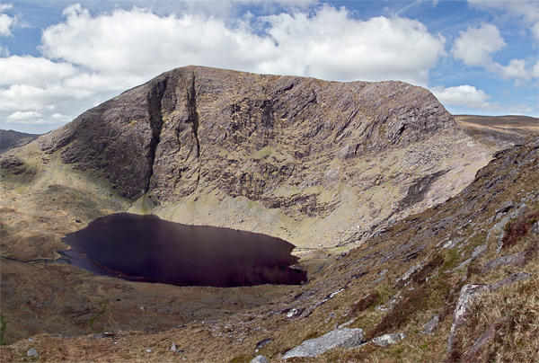
Picture: Eagle's Lough under Knocknagantee
Knocknagantee is a high perch which looks out over Sneem, Kenmare Bay and on to the Beara Peninsula and the Caha Mountains. It's about half way along the fairly linear chain of mountains that link the coast near Caherdaniel to the Ballaghbeama Gap. The hill is particularly impressive to the east, where its cliffs loom over the peaceful Eagle's Lough. Care needs to be taken in the area to the E of the summit.
S. Start from the farm at Gloragh, Eagles L (V66898 71239). Use can be made of a farm road leading to the W of the summit to an altitude of around 500m, from where the summit is a steep but short climb. Allow about 90 mins to the top.
Alternatively, you can leave this track at around the 300m contour and head NE over to Eagle's Lough. From here, follow the stream up to Lough Coomanassig and head straight out the back of the coum before swinging W then SW to the flattish summit marked by a stone pyramid. Allow 2.5hrs+
It can also be combined with Coomnacronia, Corruma Mountain and Knockmoyle in a 5-hour circuit starting from the above location or from opposite some farm buildings at A (V67483 70683).
W. Start at ToornBoy (V63163 73894) where you can park with permission. Head for the first of the Coomavoher lakes before swinging SE up to K West Top. Y]The steep part is now behind you and there's an easy but wonderful 3k walk to the top of K. Return via Knockmoyle and the northern side of Coomavoher. Allow 6 hrs+
Notable tracks incl. track/1969, track/2833 and track/3622.
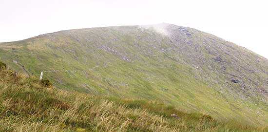
Knocknagantee can be reached as part of a circuit of Coomavoher or as described by csd. The end of a track is shown to the left of a white post in the foreground of the picture which was taken from SW of the summit. This track can be reached from roads to the east.
Knocknagantee sticks out like the prow of a ship heading south. An impressive southern marker of the flat boggy plateau to the north of it. Linkback: mountainviews.ie/summit/147/comment/1940/
Read Less
Read More
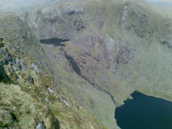
Picture: Knocknagantee
eric on Knocknagantee
by eric
19 Dec 2005
Knocknagantee - East Ridge (On the right) with Kenmare Bay and Beara Peninsula beyond. This photograph was taken north of Lough Coomanassig (O.S. Map 78: B (V675 737)) which is at the base of the East Ridge. Lough Coomanassig feeds via a spectacular waterfall into the larger Eagle's Lake located at the base of the south-east facing side of Knocknagantee. The summit of Knocknagantee is about 650 metres southwest from the top of the ridge. Linkback: mountainviews.ie/summit/147/comment/2088/
Read Less
Read More
Picture: Lough Coomanassig spilling into Eagles Lough
peterkerry on Knocknagantee
by peterkerry
3 Jun 2009
Great walking in the area with the great weather last weekend! We started up the road/track from the farmyard in Gloragh then cut off east to the base of Eagles Lough, up the LHS of the waterfall & kept left of Lough Coomanassig heading straight out the back of the coom before swinging west then south-west to the flatish summit marked by a stone pyramid (man made!). Descended via the farmers road which isn't far WNW from the summit.
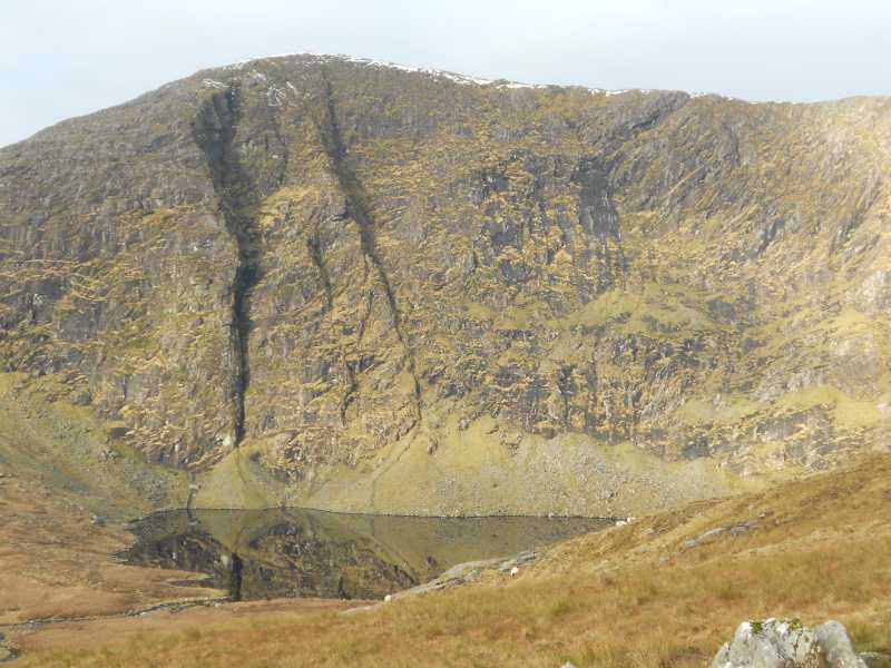
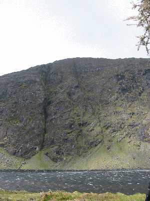
Picture: Dramatic eastern cliffs over Eagles Lough.
Bedposts of the boggy bower.
by simon3
26 Apr 2011
Knocknagantee and Coomnacronia are two of the bedposts of the sagging mattress which is the upland bounded by them, Knockmoyle and Coomura to the north. A wild, remote spot made more difficult by a number of barbed wire fences.
One place to get a fine view of the cliffs of Knocknagantee is from the steep ground SW of Coomnacronia which is about 1km to the east, over Eagles Lough. Unusually the bigger cliffs of Knocknagantee, some 350m high, face east or south-east which you can see extending right from the top in the picture.
On the extreme right of the photo, Lough Coomanassig is just visible, though it is better seen in peterkerry's exciting picture. Linkback: mountainviews.ie/summit/147/comment/6312/
Read Less
Read More
csd on Knocknagantee
by csd
20 May 2003
Access to Knocknagantee is slightly tricky - follow the instructions in "Best Walks" to the letter and you will eventually end up at the farm near Eagles L (V669 712). If your car is in any way low slung, you'll need to take it very gently! The route itself is fairly straightforward, a circuit of Eagles Lough, Lough Coomanassig, and the summit of Knocknagantee itself. Keep well to the left of the waterfall on the way up to Coomanassig - the spray can make things quite slippy. Pick up the farm track on the way down off the summit (head west) - note that the track extends much further NNW than is shown on the OS map. Photo shows Knocknagantee from the eastern shore of Eagle's Lough. Linkback: mountainviews.ie/summit/147/comment/504/
Use of MountainViews is governed by conditions and a privacy policy.
Read general information about the site. Opinions in material here are not necessarily endorsed by MountainViews.
Hillwalking is a risk sport. Information in comments, walks, shared GPS tracks or about starting places may
not be accurate for example as regards safety or access permission. You are responsible for your safety and your permission to walk.
See the credits and list definitions.


 Our Facebook page.