Donation Request 2024

DONATE
Members and Supporters, the MountainViews Committee requests your help to meet the costs of the website and of other activities such as insured events or publications.
You do not have to be logged in to donate.
Features
Nearby features appear when you click the map.
Declutter tracks on map.
Place Search
Video
X
Pub: by
Sperrin Mountains Area , NW Cen: Glenelly North West Subarea
Feature count in area: 64, by county: Derry: 34, Tyrone: 39, of which 9 are in both Derry and Tyrone, OSI/LPS Maps: 12, 13, 6, 7, 8
Highest Place: Sawel 678m

Starting Places (21) in area Sperrin Mountains:
Altinure Road, Banagher Glen Nature Reserve, Barnes Gap Car Park, Crocknakin, Drumnaspar Picnic CP, Glenchiel Road, Glenedra Bridge, Glenelly Road, Parkreagh, Goles Road, Lough Ouske, Moneyneany Village, Moydamlaght Forest, Moydamlaght Road, Mullaghmore, Mullaghbane, Spaltindoagh, Sperrin Hamlet, Sperrin Heritage Centre, Sperrin Heritage Centre W, Sperrin Road, Barnes Top, Sperrin Road, Glashagh Bridge, Sperrin Road, Sperrin

Summits & other features in area Sperrin Mountains:
E: Magherafelt Hills: Slieve Gallion NE Top 493.6m
E: Magherafelt Hills: Slieve Gallion 526.6m
N: Claudy Hills: Crockdooish 321m, Curradrolan Hill 270m, Eglish 277m, Letterlogher 249m, Mullaghmeash Hill 244m, Slieveboy 259m, Straid Hill 303m
NE Cen: Glenelly North East: Barnes Top 456m, Craigagh Hill 460m, Crockbrack 526.1m, Knockanbane Mountain 441m, Meenard Mountain 620m, Meenard Mtn W Top 480m, Mullaghaneany 627m, Mullaghash 480m, Mullaghsallagh 485m, Oughtmore 569m, Spelhoagh 568m
NE: Glenshane North: Benbradagh 465m, Boviel Top 454m, Carn Hill 448m, Carntogher 464m, Moneyoran Hill 414m
NE: Glenshane South: Bohilbreaga 478m, Coolnasillagh Mountain 423m, Corick Mountain 430m, Crockalougha 407m, Mullaghmore 550m, White Mountain 537m
NW Cen: Glenelly North West: Dart Mountain 619m, Dart Mountain North-West Top 525m, Learmount Mountain 489m, Learmount Mountain South Top 492m, Mullaghasturrakeen 581m, Mullaghcarbatagh 517m, Mullaghclogha 635m, Mullaghclogher 572m, Mullaghdoo 568m, Sawel 678m
NW: Maheramason Hills: Clondermot Hill 220m, Gortmonly Hill 218m, Slievekirk 370m
SE Cen: Glenelly South East: Carnanelly 562m, Carnanelly West Top 503.4m, Mullaghbane 467m, Mullaghturk 416m
SE: Cookstown Hills: Cregganconroe 300m, Fir Mountain 362m, Oughtmore 382m
SW Cen: Glenelly South West: Clogherny Top 408m, Craignamaddy 385m, Crocknamoghil 335m, Mullaghbolig 442m, Spaltindoagh 420m
SW: Mullaghcarn: Curraghchosaly Mountain 416m, Mullaghcarn 542m, Mullaghcarn South Top 525m
SW: Newtownstewart Hills: Bessy Bell 420m, Mullaghcroy 242m
W: Strabane: Balix Hill 403m, Knockavoe 296m, Owenreagh Hill 400m

Note: this list of places may include island features such as summits, but not islands as such.
Rating graphic.
Sawel, 678m Mountain Samhail Phite Méabha A name in Irish,
Place Rating ..
(Ir. 'Samhail Phite Méabha' [DUPN], 'resemblance of Maeve’s
vulva')
County Highpoint of Derry & Tyrone and in Derry/ Tyrone counties in Ulster province, in County Highpoint, Arderin, Vandeleur-Lynam, Irish Highest Hundred Lists, Sawel is the highest mountain in the Sperrin Mountains area and the 149th highest in Ireland. Sawel is the highest point in county Derry and also the highest in Tyrone.
Grid Reference H61796 97305, OS 1:50k mapsheet 13
Place visited by: 459 members, recently by: michaelseaver, rhw, purpleknight, discovering_dann, Prem, knightsonhikes, Bob-the-juggler, JordanF1, MarionP, edowling, ronanmckee, ToughSoles, Padraigin, jimmel567, Moirabourke
I visited this place: NO (You need to be a logged-in member for this.)
Longitude: -7.039464, Latitude: 54.819745, Easting: 261796, Northing: 397305, Prominence: 657m,  Isolation: 1.8km, Has trig pillar
ITM: 661731 897294
Bedrock type: Psammite & semipellite, (Dart Formation)
Notes on name: This rather colourful name seems to derive from the appearance of the glen on the S side of Sawel.
  Short or GPS IDs, 6 char: Sawel, 10 char: Sawel

Linkback: https://mountainviews.ie/summit/144/
Gallery for Sawel (Samhail Phite Méabha) and surrounds
Summary for Sawel (Samhail Phite Méabha): Dual county highpoint with great views.
Summary created by markmjcampion, Harry Goodman, gerrym 2023-05-09 09:42:25
            MountainViews.ie picture about Sawel (<em>Samhail Phite Méabha</em>)
Picture: Sawel from the South
Sawel, high point of both Derry and Tyrone, is the boggy highpoint of the relatively unwalked Sperrin mts. It’s a steep hill with good access and navigation is easy along its most popular ascent route. However, be prepared for sudden changes in weather. Great views abound over the N of Ireland from Donegal to Antrim.

E. Park at the pass on the Sperrin Road at Sperrin Road, Glashagh Bridge (H63895 97496). A fence goes up W and provides a sure guide to the summit area. At A (H61896 97314), a fence junction, go right up to the trig pillar. 1 hr+

W. Start at B (H58949 96935) where there is ample road parking near a cattle grid. Just N along the road a fence can be followed up ESE to Dart Mt. From the top head NE down a rocky slope to a wide saddle C (H61138 96745) and then up along a fence to a junction. The summit lies a short distance NE on the other side. 2 hrs

With two cars these two routes can be combined to make a fine linear walk.

N. Park near D (H60809 00807) and walk down the road to E (H61552 00129). From here follow a path SE onto the N spur and ascend steeply for c. 2k to the summit. 1.5 hrs+

S. Longer alternatives incl starting at the Sperrin Heritage Centre Sperrin Heritage Centre (H607 935) or at Sperrin Hamlet (H63903 94414).

The accepted view in the past has been that Sawel is the highpoint of D and T but alternative views posted on the site now suggest that the high point of Tyrone may lie either some 30/40 metres S of the trig pillar or within 3 metres of it.

Notable tracks incl. track/1408, track/2216 and track/2257.
Linkback: mountainviews.ie/summit/144/comment/4904/
Member Comments for Sawel (Samhail Phite Méabha)
Comment create / edit display placeholder

            MountainViews.ie picture about Sawel (<em>Samhail Phite Méabha</em>)
Picture: Summit of Sawel at 9am on Tuesday morning last
wicklore on Sawel
by wicklore 31 Oct 2008
At 6:50am on Tuesday morning last I sat in my car on the lonely Barnes Road to the east of Sawel at F (H639 974). I was parked at a double gate, but careful not to block it. The outside temperature gauge read -1 Celsius and it was dark. Terrible weather was predicted but so far it had just rained. I spent some time getting my full winter gear on as I waited for the sun to rise. At 7:20 when it was light I headed up along the fence which led from the road up the eastern side of Sawel. It was soon joined by another fence and I continued to follow it east for the next 1.5 hours. Gerrym’s comment on the fence leading almost to the summit provided comfort as a shocking hail and snow storm unleashed itself upon me. Soon the ground was covered in icy snow and the going got much tougher. Visibility was down to maybe 30 feet at times but following the fence made navigation easy. However both gps and compass were constantly checked. At point G (H619 973) the fence veered SW and I struck off to follow the slope uphill into the freezing fog and snow. This would be the only real navigation challenge of the day, and it turned out not to be a challenge as within a few minutes I came to the summit pillar. The contrast of black and white as the pillar rose out of the frozen ground made it look like a pencil drawing. Experience told me not to leave my gloves off for more than half a minute when taking photos. Even at that my hands were freezing and made putting my gloves back on difficult. While I did not benefit from any views I had bagged two County Tops with one mountain. The severe weather and the fact I was alone meant an extension to Dart Mountain was out of the question. I simply retraced my route back to the fence and followed it down to the road just over 2 kms away. While the fence made this route a straightforward handrail to the summit, it provided a great safe route to test winter gear in such weather. One thing that surprised me was that large balls of compact ice formed under my boots, providing me with ‘stilts’. Possibly the snow was getting caught in my gaiter straps underfoot, and then forming into lumps. Walking poles were used to knock these off every so often, but it was the first time I had experienced this. Linkback: mountainviews.ie/summit/144/comment/3409/
Read Less
Read More

            MountainViews.ie picture about Sawel (<em>Samhail Phite Méabha</em>)
Picture: Sawel
A 'very' Shapely Top
by gerrym 11 Feb 2014


http://youtu.be/4GvIMiEx408

Sawel may not be as exciting or as impressive as some hills in other parts of the country, but it is a special hill among a special range of hills. The fact that it is named after a part of the female anatomy (and indeed looks the part if you see the pic) can only add to the charm!

The best approach is along the high and lonely Sperrin road which heads upward out of the hamlet (even this is over descriptive) of Sperrin. Parking is available at an extensive layby at Sperrin Hamlet (H639 944). The road rises alongside Oughtnamwella Burn and brings increasingly impressive views over the Glenelly valley. It is most definitely worth the walk but there is also room to park at the high pass at over 1000ft - think of the exercise!

From the pass take the fenceline rising up the long E shoulder of Sawel, the going is steady with steeper sections but it is not too challenging and the fence is reassuring in poor weather - it is only near to the summit that need to leave its side and head off a short distance to the rare sight of a trig pillar in the Sperrins.

I would challenge anyone (in a duel to near death, preferably with pillows) to tell me that the views from here on a clear day can be beaten by another mountain in Ireland. Basically every county in Ulster is within sight of glazed eyes - at the amazingness of it all and in no way to do with drug use. Where else could you see nearly all of the hills of Donegal and all the way across to the hills of Antrim at the other side of Ireland? The whole of the Sperrin range is visible in all its glory, and as i have said in another comment this hill could on occasion make me briefly turn away from my steadfast atheism.

Sawel carries stature in being the highest point of the large Sperrin range and holds the weight of two county tops. For all this it is still a rare sight to see someone else on the mountain, even at the weekend, something that adds to its appeal i feel.

Return is by the same route but as you have come this far it is well worth travelling across the broad col and up to the summit of neighbouring Dart, which is different in character. Wait for a clear day, preferably one of those with a northerly breeze and the clear air that extends views and sharpness to truly experience the magic of the Sperrins - I know! Linkback: mountainviews.ie/summit/144/comment/825/
Read Less
Read More

            MountainViews.ie picture about Sawel (<em>Samhail Phite Méabha</em>)
Picture: Looking east from the highest point in Tyrone
slemish on Sawel
by slemish 20 Nov 2009
This was my first venture into the Sperrins and where better to start than the daddy of them all? Sawel looked majestic in the afternoon sunshine as I approached it via the road from Sperrin. Wanting a quick up and down, I parked at the second cattle grid as others suggested from here it is the easiest route up (F (H639 974)). It's a long climb but not too steep, only in a couple of places did I find the going tough. The summit looks incredibly far away on the initial stages so I didn't stray too far from the fence, just to avoid boggy sections. It was amazingly sunny for late November and I was enjoying the weather, but nothing prepared me for the force of the wind coming up from Dart as I approached the 678m summit. I couldn't stand at the trig pillar for more than about a minute. The trig pillar looked very weather-beaten and no wonder. The only comparable wind I had experienced before was on Trostan but this was definitely worse. Excellent views however down the ridge to Dart and Mullaghclogha, north to Sleve Snaght and Binevenagh and round to Benbradagh and the lower Sperrins. It's only up here you get a sense of the scale and indeed the wilderness of the Sperrins. To the east I could just make out the outlines of Knocklayd, Slievenanee and Slemish through the haze. I made a hurried sortie over the fence to bag the county top of Tyrone as well, then descended quickly to get out of the wind. Job done - the highest mountain I've climbed so far and the first over 2000ft. Total trip - about 1.5 hours. Linkback: mountainviews.ie/summit/144/comment/4275/
Read Less
Read More

Derry / Tyrone County Top
by Gribster 23 Aug 2010
As I near the completion of my 2010 County Tops challenge, I would like to inform my fellow County Toppers about something I've recently learned about Sawel Mountain. A few weeks ago, I followed the “county boundary” fence to the summit from Sperrin Road. The fence passes about 10m west of the summit trig pillar which supposedly marks the County Top of Derry. I walked westwards from it to the highest point along the fence about 10m west. There were two small boulders - one each side of the fence - which served nicely as a stile. The boulder on the west side of the fence seemed the most likely location of the County Top of Tyrone, so I felt a need to stand on it. I realise there can be a lack of precision associated with certain County Tops (see my MV entry for Seltannasaggart SE Slope), and I wanted to be absolutely sure about this one too. OSNI 1:50,000 Sheet 13 and 1:25,000 Sperrins Activity Map both show the county boundary passing very close to the Sawel Mountain trig pillar. In fact, the Sperrins Activity Map clearly shows the boundary deviating away from the fence to possibly pass through the pillar. I checked with OSNI, and they've informed me that the county boundary is an "undefined" boundary (i.e. one which is not coincident with any feature). If the fence had marked the boundary, it would have been a "defined" boundary. This confirms that the fence, used by many people as a navigational guide to the summit, doesn’t mark the county boundary. OSNI also checked the location of the trig pillar and the county boundary on their digital mapping. From this, they measured that the trig pillar lies 0.8m on the Tyrone side of the county boundary. However, they could only confirm an accuracy of 2m - in other words, the trig pillar could be 2.8m into Tyrone or it could just as easily be 1.2m into Derry. A townland boundary also crosses the summit, intersecting the county boundary within 2m of the trig pillar. The proximity of these two boundaries to the trig pillar and the 2m accuracy of the mapping leads me to believe that the trig pillar marks the point where the county and townland boundaries intersect. While it’s not possible to pinpoint the County Top of either Derry or Tyrone based on the most accurate large-scale mapping available, there appears to be a strong possibility that the Sawel Mountain trig pillar marks the top of both counties. It certainly marks the top of at least one. If it marks the top of Derry only, then the top of Tyrone is up to 1.2m to the south of it. If it marks the top of Tyrone only, then the top of Derry is up to 2.8m to the north of it. Based on the high level of uncertainty and the tiny distances involved, it is best to assume that the trig pillar is located directly on the county boundary and marks the County Top of both Derry and Tyrone. To be absolutely sure you get both counties, walk a tight circle around the trig pillar and then spiral out gradually until you are 2.8m from it. It's the only way to be sure. Linkback: mountainviews.ie/summit/144/comment/6047/
Read Less
Read More

            MountainViews.ie picture about Sawel (<em>Samhail Phite Méabha</em>)
Picture: The sight of a near full moon rounded off a fabulous afternoon on Sawel
kernowclimber on Sawel
by kernowclimber 1 Mar 2010
After following the weather forecast to see where we might get in a good winter climb, we settled on the Sperrins which, if the Met Office was to be believed, had apparently received some snow the day before (Fri 26th). Driving into Cookstown we caught our first real views of the Sperrins; they had indeed gotten a huge dump of snow that far exceeded our expectation. We took the first road right on the B 47 after Glenerin Bridge and just before the hamlet of Sperrin. This mountain track leads up towards the foothills of Sawel that was to be our objective for the day.

We were almost thwarted in our endeavour by the accumulation of snow on the road and not having a 4X4 and a car without its winter tyres meant it was difficult to find a place to park alongside the road where we wouldn’t get stuck. We found a turning about a kilometre up the road to park safely and walked parallel to Oughtnamwella Burn to Sperrin Road, Sperrin (H633 952) where a gate leads into a field that is bordered by a fence. This fence that runs up towards the summit can be used as an aid to navigation in inclement conditions.

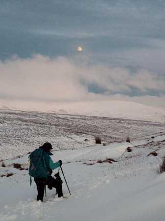
The snow was much deeper than we had thought it would be and we regretted not having our snowshoes with us, which had propelled us rapidly up Lugnaquillia last month. The snow was well over a foot deep and on the lower slopes was quite loose and mushy. Between the peat hags, it had drifted and was waist deep making it hard going to maintain upward progress.

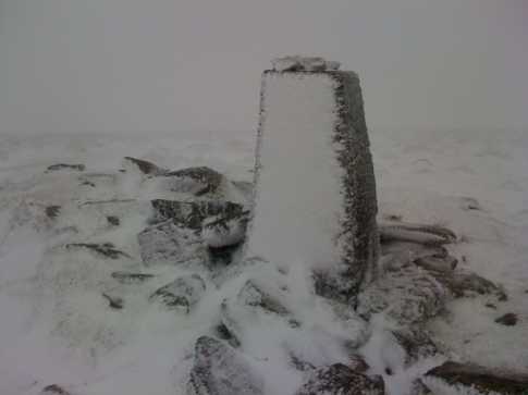
As we ascended the snow became more compact and easier to walk on, but the temperature began to plummet. Close to the summit the cloud closed in and the wind picked up, creating poor visibility in sub-zero conditions. We located the trig point, misshapen and contorted by ice, with the aid of our GPS. As we hopped the ice laden fence to bag the highest point in Tyrone, the sinking sun appeared through the swirling cloud as a watery orb, casting an eerie, pale apricot other-worldly hue over everything. It reminded me of the planet LV-426 in Alien!

As we were being severely buffeted by icy winds at this point and thankful that our winter kit was repaying the money we had dished out on it in spadefuls, we decided to make our descent. As we came through the cloud we were greeted by the sight of the rolling landscape bathed in the rose-coloured glow of the setting sun. As we feasted our eyes on this spectacle, the near full moon drifted up from behind Oughtmore and Mullaghsallagh.

Four hours later we arrived back to our car in the twilight. We might not have had the extensive views of the north of our island so eloquently described by other members of Mountain Views, but the winter and atmospheric conditions we experienced made this climb truly memorable. Linkback: mountainviews.ie/summit/144/comment/4454/
Read Less
Read More
EDIT Point of Interest
text
Videos


Recent Contributions
x
Conditions and Info
Use of MountainViews is governed by conditions and a privacy policy.
Read general information about the site.
Opinions in material here are not necessarily endorsed by MountainViews.
Hillwalking is a risk sport. Information in comments, walks, shared GPS tracks or about starting places may not be accurate for example as regards safety or access permission. You are responsible for your safety and your permission to walk.
See the credits and list definitions.

OSi logo
OSNI/LPS logo
Open Street Map
(Various variations used.)
British summit data courtesy:
Database of British & Irish Hills