Members and Supporters, the MountainViews Committee requests your help to meet the costs of the website and of other activities such as insured events or publications.
Feature count in area: 16, all in Kerry,
OSI/LPS Maps: 71, EW-DC, EW-DE
Highest Place: Baurtregaum 849.7m
Starting Places (15) in area Slieve Mish: Caherconree Scenic Route, Derrymore West Trail, Doonore South, Emlagh Cross, Emlagh Wood, Feighatidura Cove, Glanaskagheen Wood, Greenlawn Cross, Laharn Viewpoint, Lougher, Maum Cross, Maumnahaltora Cross, R561 Lissaroe, Tonavane Cross, Tonavane Walk Kerry Camino
Summits & other features in area Slieve Mish: Cen: Baurtregaum: Baurtregaum 849.7m, Baurtregaum Far NE Top 601.2m, Baurtregaum NE Top 818.5m, Baurtregaum NW Top 723m, Caherconree 835m, Castle Hill 600m, Gearhane 792m E: Barnanageehy: Barnanageehy 561m W: Aughils: Beenduff 515m, Caherbla 585.2m, Emlagh 483m, Knockbrack 459m, Knockmore 565m, Lack Mountain 465m, Moanlaur 566m W: Camp: Corrin 332m
Note: this list of places may include island features such as summits, but not
islands as such.
Knockmore, 565mMountain An Cnoc Mór A name in Irish,
Place Rating ..
Ir. An Cnoc Mór [OSi], 'the big hill', Cruckmore, Cruach Mór, Kerry County in Munster province, in Arderin Beg Lists, Knockmore is the 377th highest place in Ireland.
Grid Reference Q68441 04251,
OS 1:50k mapsheet 71 Place visited by: 48members, recently by: maoris, garrettd, a3642278, johncusack, Grumbler, Taisce, chelman7, Moses, Marykerry, John.geary, mh400nt, annem, daitho9, Ulsterpooka, Fergalh
I visited this place: NO (You need to be a logged-in member for this.)
Longitude: -9.923836, Latitude: 52.174862, Easting: 68441, Northing: 104251,
Prominence: 27m, Isolation: 0.6km ITM: 468419 604306 Bedrock type: Conglomerate with metamorphic clasts, (Inch Conglomerate Formation) Notes on name: Previously Moanlaur South-West Top in MV.
Short or GPS IDs, 6 char: Knc565, 10 char: Knockmore Linkback: https://mountainviews.ie/summit/1425/
Gallery for Knockmore (An Cnoc Mór) and surrounds
Summary
for Knockmore (An Cnoc Mór):
A short trip from Moanlaur
Summary created by liz50
2019-01-05 19:51:34
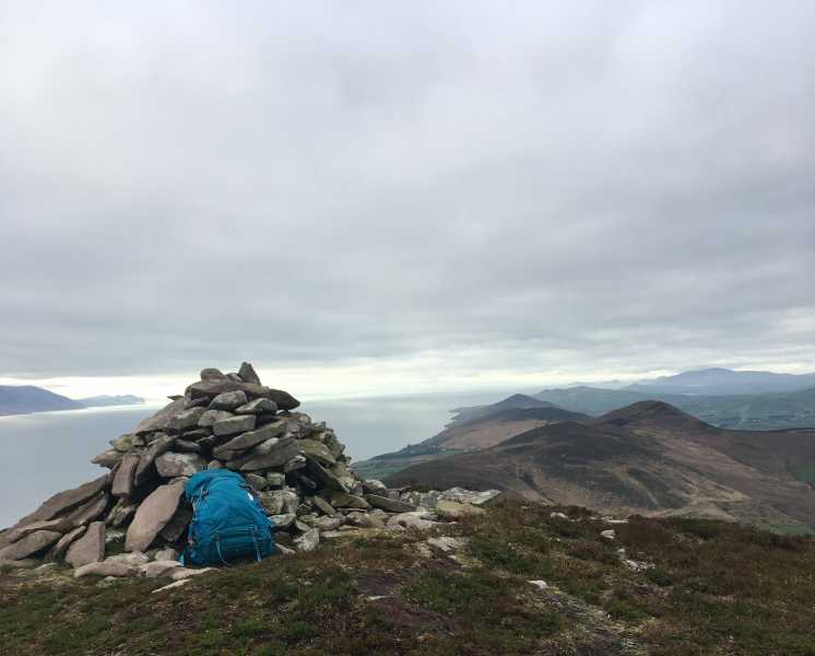
Picture: Looking towards Knockmore and Moanlaur from summit of Cnoc an Stuaic
Park at A (Q717 056) A, the highest point of the Aughils to Camp road, where there is room for 1/2 cars. Head directly west, following a bog road at B (Q716 053) to avoid the worst of the knee-high heather for about 1km. The slope gradually increases and becomes quite steep at around 400m ascent. The heather disappears and the terrain is mostly grass and rock, and firm underfoot, and after 1.5km you will reach the summit of Knockbrack at 459m, a longish summit area with the highest point, which is at the eastern end, being quite indistinct. Continue west passing some rocky outcrops at the western end of Knockbrack, and descend about 35m to a col before turning south west and making a gradual ascent of Moanlaur over 1km. Continue along the ridge to a short drop to a col and a short ascent to the summit of Knockmore. 1.5 hours from car to summit.
Use of MountainViews is governed by conditions and a privacy policy.
Read general information about the site. Opinions in material here are not necessarily endorsed by MountainViews.
Hillwalking is a risk sport. Information in comments, walks, shared GPS tracks or about starting places may
not be accurate for example as regards safety or access permission. You are responsible for your safety and your permission to walk.
See the credits and list definitions.


 Our Facebook page.