This website uses cookies, which are small text files that the website puts on your device to facilitate operation. Cookies help us provide a better service to you. They are used to track general user traffic information and to help the website function properly.
Feature count in area: 45, all in Donegal,
OSI/LPS Maps: 11, 6
Highest Place: Croaghgorm 674m
Starting Places (22) in area Bluestack Mountains: An Leathchruach, Barnsmore Gap, Bensons Hill, Caldragh CP, Clogher South peak, Cruach Mhín an Neanta, Doobin, Eanybeg Water Bridge, Edergole Farm, Gaugin Mountain, Glennacree CP, Hillhead, Lough Finn West, Lough Magrath Beg NE, Lough Muck North, Meenaguse Lough, Sand Lough Forest Picnic Area, Scoil Náisúnta an Choimín, Sheskinlubanagh, Sruell Gap Farm, Sruell River Road, St Columbkilles Well and Altar
Summits & other features in area Bluestack Mountains: Cen: Reelan Hills: Altnapaste 364m, Gaugin Mountain 565m, Lacroagh 403m, Boultypatrick 429m, Croveenananta 476m, Croaghubbrid 416m, Croaghugagh 410m N: Fintown Hills: Aghla Mountain South Top 589m, Aghla Mountain 593m, Scraigs 426m, Croaghleheen 385m NW: Glenties: Cloghercor South 301m, Derkbeg Hill 332m, Drumnalough Hill 282m S: Belshade: Croaghgorm 674m, Croaghgorm South-West Top 597m, Croaghgorm East Top 594m, Ardnageer 642m, Ardnageer SW Top 626m, Banagher Hill 392m, Croaghbane 641m, Croaghgorm Far South-West Top 561m, Cronamuck 444m, Croaghbarnes 498.8m, Glascarns Hill 578.3m, Meenanea 435m SE: Barnesmore: Brown's Hill 496.4m, Cloghervaddy 402m, Croaghagranagh 440m, Croaghanirwore 546.1m, Croaghbrack 401m, Croaghconnellagh 523m, Croaghnageer 569.1m, Croaghnageer East Top 543.5m, Croaghnageer North-East Top 521m, Croaghonagh 451m SW: Eany Beg Hills: Binbane 453m, Binbane NE Top 439m, Lavagh Beg 650m, Lavagh More 671m, Binnasruell 505m, Carnaween 521m, Cloghmeen Hill 429m, Silver Hill 600m, Cullaghacro 476m
Note: this list of places may include island features such as summits, but not
islands as such.
Glascarns Hill, 578.3mMountain Croaghbane North Top A name in English,
Place Rating ..
, Donegal County in Ulster province, in Arderin Beg Lists, Glascarns Hill is the 341st highest place in Ireland.
Grid Reference G97909 91926,
OS 1:50k mapsheet 11 Place visited by: 59members, recently by: bowler, abeach, gdg, ronanmckee, dino, ochils_trekker, Krzysztof_K, simoburn, Alanjm, JoHeaney, Grumbler, Carolyn105, srr45, Sweeney, AlanReid
I visited this place: NO (You need to be a logged-in member for this.)
Short or GPS IDs, 6 char: GlscHl, 10 char: GlscrnsHil Linkback: https://mountainviews.ie/summit/1413/
Gallery for Glascarns Hill (Croaghbane North Top) and surrounds
Summary
for Glascarns Hill (Croaghbane North Top):
Fine summit on larger route
Summary created by Colin Murphy
2022-04-07 17:00:07
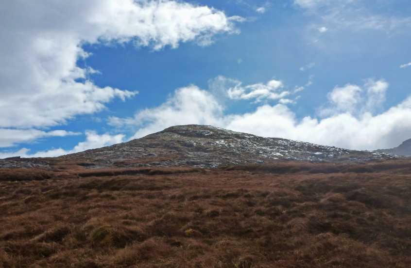
Picture: View from the north
Turn south off the Ballybofey / Glenties road and enter the Reelan River Valley, where you will see a sign for Slí na Finne. Room for 6-8 cars at the Old School Clogher S (G95935 94116). From there walk east a few metres and turn south descending towards the Reelan River along Sli na Finne. Cross the bridge and almost straight away turn east and follow the boggy wet track up to the ruined cottage, where you turn south. Once a fence is crossed after the ruined cottage, the conditions underfoot improve and the main theme is rock - slabs and boulders. The incline is not particularly challenging. Glascarns Hill is a distinct rocky top just a couple of metres short of qualifying as an Arderin. It is also often the first stop en route to multiple other mountains.
Picture: View over Cronloughan to Cronamuck and Altnapaste
A Welcome New Addition
by Aidy
16 Jun 2015
I climbed Glascarns Hill over a year ago, not knowing at the time that it would make it on to MV, and I was just using it as a stepping stone on to Croaghbane. Even then however, I was glad I went to the summit, which was a magnificent rocky top, with great views over Cronloughan lough, the Owendoo and Owengarve River valleys, and to all the surrounding mountains. I started at the old schoolhouse in the Reelan Valley, and headed south-southeast directly up the hill, keeping the Effernagh River on my right hand side as I ascended. Initially boggy ground and tussocky grass and heather, but fantastic rocky terrain nearer the top. Glad to see it on here. I continued on to Croaghbane before being driven back down by possibly the strongest winds i've yet experienced on a mountain. Linkback: mountainviews.ie/summit/1413/comment/18130/
Use of MountainViews is governed by conditions and a privacy policy.
Read general information about the site. Opinions in material here are not necessarily endorsed by MountainViews.
Hillwalking is a risk sport. Information in comments, walks, shared GPS tracks or about starting places may
not be accurate for example as regards safety or access permission. You are responsible for your safety and your permission to walk.
See the credits and list definitions.


 Add a Place Comment for Glascarns Hill, Croaghbane North Top


 Our Facebook page.