Cookies.
This website uses cookies, which are small text files that the website puts on your device to facilitate operation. Cookies help us provide a better service to you. They are used to track general user traffic information and to help the website function properly.
Features
Nearby features appear when you click the map.
Declutter tracks on map.
Place Search
Video
X
Pub: by
Partry & Joyce Area , W: Devilsmother Subarea
Feature count in area: 27, by county: Mayo: 15, Galway: 15, of which 3 are in both Galway and Mayo, OSI/LPS Maps: 37, 38, CBE, EW-CON, MSW
Highest Place: Maumtrasna 682m

Starting Places (54) in area Partry & Joyce:
Aasleagh Waterfall CP, An Móinín Mór, Ballydoo Lough, Barrevagh Bridge, Bealanabrack River Tributary, Black Rock, Bohaun, Bracklagh, Buckaun, Bunduvowen, Cammanagh, Carraig Bar, Carrowrevagh Lough, Clonbur, Cummer, Derrassa, Derrinkee Wood, Doon Rock, Failmore River, Finny Church, Fooey River Road, Glendavock, Glenmask, Glennacally Bridge, Glensaulmore Trailhead, Glentraigue, Gowlaunlee Lake, Keelkill North, Killeennimat Burial Ground, Knockaunnabausty (Cnocán na bPáistí), Knocknafaughy SW, L Mamwee, Lecarrow, Leenane, Leenane Hotel, unuseableLeenane R336, Lough Nambrackkeagh, Maum Bridge Road Lower, Maum Bridge Road Mid, Maum Bridge Road Upper, Mount Gable CP, Otter Pool, Owenbrin Bridge, Owenbrin Tributary, Owenduff River, Red Island, RIC Barracks Ruin, Rinavore East, Rinavore SW, Shanafaraghhaun Cross, Sheeffry Pass, Tawnyard Lough, Teevinish West, The Larches Pub

Summits & other features in area Partry & Joyce:
Cen: Finny: Glenbeg East 372m
Cen: Knocknafaughy: Knocknafaughy 254m, Rinavore 426m
Cen: Maumtrasna: Barnahowna 516m, Buckaun East 495m, Glennagleragh Mtn 617m, Knocklaur 518m, Maumtrasna 682m, Maumtrasna North-East Top 572m, Tullymorehill 279m
N: Ballintober Hills: Bohaun 393m, Corveagh 233m, Croaghrimkarra 271m, Keelkil 239m
SE: Cornamona: Mount Gable 417.8m, Bohaun 424m, Knocknagussy 456m
SW: Bunnacunneen: Ben Beg 560m, Bunnacunneen 575m, Bunnacunneen South Top 539m, Bunnacunneen SE Top 479m, Lugnabrick SW Top 494m, Lugnabrick NE Top 494m
W: Devilsmother: Devilsmother 645m, Devilsmother South Top 509m, Devilsmother North Top 595m, Devilsmother Far North Top 601m

Note: this list of places may include island features such as summits, but not islands as such.
Rating graphic.
Devilsmother North Top, 595m Mountain Binn Gharbh (mullach thuaidh) A name in Irish,
Place Rating ..
For origin of name, see Binn Gharbh / Devilsmother., Magairlí a' Deamhain, Mayo County in Connacht province, in no lists, Binn Gharbh (mullach thuaidh) is the 303rd highest place in Ireland. Binn Gharbh (mullach thuaidh) is the second most westerly summit in the Partry & Joyce area.
Grid Reference L91616 63340, OS 1:50k mapsheet 37
Place visited by: 92 members, recently by: srr45, Carolyn105, Wilderness, Krzysztof_K, Niamhq, bryanjbarry, glencree, TommyMc, Sweeney, ryanguinness10, elizauna, mrfleetfoot, Haulie, abcd, Grumbler
I visited this place: NO (You need to be a logged-in member for this.)
Longitude: -9.638249, Latitude: 53.608844, Easting: 91616, Northing: 263340, Prominence: 12m,  Isolation: 0.9km
ITM: 491589 763359
Bedrock type: Sandstone & conglomerate, ignimbrite, (Mweelrea Formation)

  Short or GPS IDs, 6 char: DvlsNr, 10 char: DvlsmtNrth

Linkback: https://mountainviews.ie/summit/1402/
Gallery for Devilsmother North Top (Binn Gharbh (mullach thuaidh)) and surrounds
Summary for Devilsmother North Top (Binn Gharbh (mullach thuaidh)): Simple top on the way to main summit.
Summary created by Geo, Colin Murphy 2019-09-14 10:44:36
            MountainViews.ie picture about Devilsmother North Top (<em>Binn Gharbh (mullach thuaidh)</em>)
Picture: The grassy mound that marks the top.
The most direct approach is to park at small lay-by (1-2 cars) at Otr Pl (L91270 65070) and proceed directly up steep slope in SE direction. Terrain is short grass mostly, and was solid underfoot in late May. Reach the ridge at A (L917 640) F after 1 hour 20 minutes and then follow the ridge to the south for 800m to attain the grassy mound at the summit, which is unmarked. Climb up steepest parts could be slippy after rain so take care or perhaps wait for a dry day.
The video is excellent and well worth watching as a flavour of what to expect.

Video short summary: https://www.youtube.com/watch?v=8Ov_Ocb8Agw&feature=youtu.be
Linkback: mountainviews.ie/summit/1402/comment/18030/
Member Comments for Devilsmother North Top (Binn Gharbh (mullach thuaidh))
Comment create / edit display placeholder

            MountainViews.ie picture about Devilsmother North Top (<em>Binn Gharbh (mullach thuaidh)</em>)
Picture: Top ten walk?
Friday 13th... Lucky for me!
by Geo 14 Sep 2019
A crisp early morning in September.
The mist shimmering over the lakelets as I drive the winding road north from my base in Roundstone.
A night of fitful sleep the night before worrying through the walk ahead as I face what I know are steep unforgiving slopes protecting the Dam of Satan and her offspring.
I need not have worried.
I park in the little layby hugging the edge of the N59, backing my trusty Renault into as safe and small a footprint as I can, not wishing to prevent others the chance to pullover here and ooh and ah at the majesty of God's own country.
And I'm off, over the fence and heading East to meet the beast herself.
The vegetation is handy going, grass shorn by the blackfaces that live hereabouts and I keep myself ever upward minding the big ravine to my left.
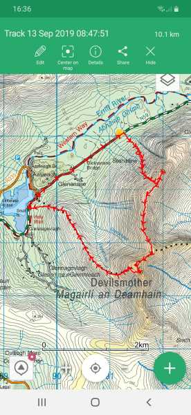
An hour and a little later and it's well Wow! I'm on a ridge that really shouts pure class. I take a left, careful not to miss my main event today, the VL that is the Far North Top. Now I've only 10 to go!
I volte face and head South, the whole ridge rising and falling in front of me, daring me to come on, I almost dance with pleasure as the sun gives me a boost and propels me on with her energy.
This top, the North Top could be one of many along here but who cares, the ups and downs are kind and easy and every knoll is worth topping out on so it wont be missed.
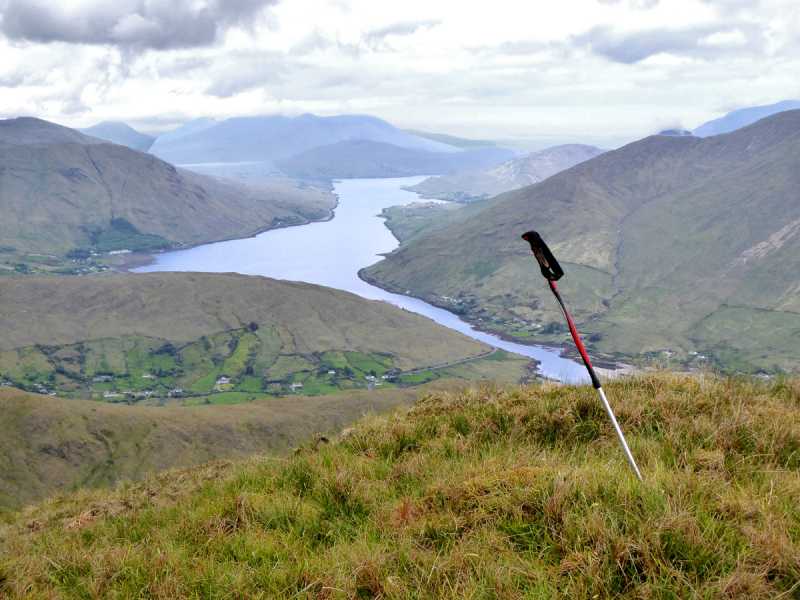
My biggest problem is the views, stupendous, vertiginous, crazily beautiful mountains are all around, even the cranky old hag queen Mweelrea has thrown off her seemingly perpetual cloak of mist and gloom and sits atop her throne above the mirrored fjord holding court over the great and good of Galway and Mayo. I keep my feet though despite watching for safe footfall and drooling around about me at the vista.
I find myself, a brace of hours in, at the summit cairn of the mother herself, pinching myself as to how I've done this walk so quickly despite the ascent. I take a moment to take in a positive recharge to my mental state, to get me through the long dark teatime of the soul that is winter ahead.
Reality again strikes, for a brief moment I toy with the idea of pushing on to the South top, it looks ok, there’s a grand spur off it takes one down to the N59 again, but I falter, I've given my route to herself and what if something happens? I’ll play it safe.
A little navigating needed now despite the clarity around me, the correct way off to the spur I need requires me to think clearly for a few minutes, but thankfully I get a good vector and I'm off, downhill, sharply at first, but then the slope becomes kinder and before I know it I'm down again on the N59, the Leenane side of the C of I church at Aasleagh.
Half an hour on the tarmac and I'm reunited with my carriage and happily running an eye around the skyline on a potential top ten walk.
Thank you Devilsmother... Linkback: mountainviews.ie/summit/1402/comment/20652/
Read Less
Read More

Big Plateau
by srr45 29 Feb 2024
The Devilsmother and sister tops are superb and down the ridge to Knocklaur and on to the Plateau in Maumtrasna. Great North face around knocklaur. Linkback: mountainviews.ie/summit/1402/comment/24145/
Read Less
Read More
EDIT Point of Interest
text
Videos


Recent Contributions
x
Conditions and Info
Use of MountainViews is governed by conditions and a privacy policy.
Read general information about the site.
Opinions in material here are not necessarily endorsed by MountainViews.
Hillwalking is a risk sport. Information in comments, walks, shared GPS tracks or about starting places may not be accurate for example as regards safety or access permission. You are responsible for your safety and your permission to walk.
See the credits and list definitions.

OSi logo
OSNI/LPS logo
Open Street Map
(Various variations used.)
British summit data courtesy:
Database of British & Irish Hills