This website uses cookies, which are small text files that the website puts on your device to facilitate operation. Cookies help us provide a better service to you. They are used to track general user traffic information and to help the website function properly.
Feature count in area: 9, by county: Down: 5, Antrim: 4,
OSI/LPS Maps: 15, 20, 21
Highest Place: Divis 478m
Starting Places (2) in area Belfast Hills: Ballyherly Lough West, Castlemahon Mountain South East
Summits & other features in area Belfast Hills: E: Belfast Hills East: Cairngaver 217m, Ouley Hill 186m, Scrabo Hill 160m N: Belfast Hills North: Carnmoney Hill 231.1m, Cave Hill 368m, Divis 478m, Slievetrue 312m SE: Strangford & Portaferry: Ballywhite Hill 101m, Castlemahon Mountain 128m
Note: this list of places may include island features such as summits, but not
islands as such.
Ballywhite Hill, 101mHill
Place Rating ..
, Down County in Ulster province, in no lists, Ballywhite Hill is the 1510th highest place in Ireland. Ballywhite Hill is the most easterly summit and also the second most southerly in the Belfast Hills area. It's also the most easterly summit in Ireland.
Grid Reference J58218 52785,
OS 1:50k mapsheet 21 Place visited by: 15members, recently by: trostanite, Kirsty, Vfslb1904, Carolyn105, dregish, Fergalh, eamonoc, LorraineG60, MichaelG55, Wilderness, AntrimRambler, sandman, Garmin, Peter Walker, Harry Goodman
I visited this place: NO (You need to be a logged-in member for this.)
Short or GPS IDs, 6 char: BlywHl, 10 char: BlywhtHil Linkback: https://mountainviews.ie/summit/1380/
Gallery for Ballywhite Hill and surrounds
Summary
for Ballywhite Hill :
The only MV top listed on the Ards Peninsula - and only just made it !
Summary created by Peter Walker, Harry Goodman
2014-10-19 21:20:30
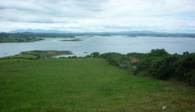
Picture: View W across Strangford Lough to the Mournes.
Leave the A20 from Newtownards to Portaferry at A (J601 543) and go SW passing Lough Cowey. At a T junction go left and continue along to B'herly L (J59058 52715) where there is space to park to the side of the road on the right fronting a house. Ensure to seek permission to park here. The road is used by tractors and other agricultural machinery and space must be left to allow passage along it. Walk back NNW for about 250 metres to a lane on the left with distinctive stone pillars at the entrance and opposite a small white house B (J58979 52954). The lane leads up to a private bungalow and, at the time of writing this ss (July 2014), while the present occupiers have no objection to using it for access to the hill their permission to do so should be sought before continuing. A metal gate to the right side of the house ('Beware of Bull' sign) leads out to a couple of large grass covered fields with the high point some 600 metres along from the house. There is no marker to indicate the top on a somewhat flat grassy area (but there is a trig column just over the fence on the right) and it is left to personal choice just where it lies. A suggested co-ordinate is C (J58223 52781). There is a fine view out across Strangford Lough to the long line of the Mourne tops and Slieve Croob. Perhaps the only notable thing about this small hill is that it is the only listed MV top on the low lying Ards Peninsula, making the list by a mere metre ! It is also the most easterly top in Ireland listed by MV .
The summit of this hill can be reached by the west side by taking a country lane which begins at D (J576 527). This country lane will lead you up to a small tower/pylon. From here you will see the gate which leads into the open fields where the top is near. There is a hidden trig pillar on the summit. I recommend you start this walk in Portaferry town and walk down the Loughshore road till you reach the country lane which will be on your right. BEWARE OF THE BULL!!! Linkback: mountainviews.ie/summit/1380/comment/18650/
Use of MountainViews is governed by conditions and a privacy policy.
Read general information about the site. Opinions in material here are not necessarily endorsed by MountainViews.
Hillwalking is a risk sport. Information in comments, walks, shared GPS tracks or about starting places may
not be accurate for example as regards safety or access permission. You are responsible for your safety and your permission to walk.
See the credits and list definitions.


 Our Facebook page.