Members and Supporters, the MountainViews Committee requests your help to meet the costs of the website and of other activities such as insured events or publications.
Feature count in area: 19, all in Cork,
OSI/LPS Maps: 84, 85, 88, 89
Highest Place: Mount Gabriel 407m
Starting Places (14) in area Mizen/Sheeps Head: Ahakista Pier, Brow Head Watch Tower, Cahergal, Carr Clós Dún Óir, Coosacuslaun Bay, Derrylahard East, Durrus Village, Kilcrohane, Letter Cillin CP, Mount Corrin Road, Mount Gabriel Road, Sheeps Head Turning Point, Sherkin Island Pier, Sui Finn Car Park
Summits & other features in area Mizen/Sheeps Head: NE: Mizen NE: Derrylahard East 301m, Knockaughna 268m, Mount Corrin 284m, Mount Gabriel 407m, Mount Kid 296.1m NW: Sheeps Head: Ballyroon Mountain 239m, Caher Mountain 338m, Fahane 233m, Gouladane 303m, Seefin 345m S: Cape Clear: Cnoicín an tSeabhaic (Clear Island) 160m S: Knockomagh: Knockomagh 197m S: Sherkin: Slievemore (Sherkin Island) 101m SW: Mizen SW: Brow Head 108m, Knockaphuca 237m, Knockatassonig 207m, Knocknamaddree 313m, Lackenakea 164m, Mizen Peak 232m
Note: this list of places may include island features such as summits, but not
islands as such.
Brow Head, 108mHill
Place Rating ..
, Cork County in Munster province, in Binnion Lists, Brow Head is the 1504th highest place in Ireland. Brow Head is the second most southerly summit in the Mizen/Sheeps Head area. It's also the second most southerly summit in Ireland.
Grid Reference V77741 23837,
OS 1:50k mapsheet 88 Place visited by: 37members, recently by: pdtempan, jlk, Taisce, chelman7, nickywood, caiomhin, daitho9, roops, Jimbo70, TommyMc, thomas_g, Cobhclimber, Fergalh, Deise-Man, ciarraioch
I visited this place: NO (You need to be a logged-in member for this.)
Short or GPS IDs, 6 char: BrwHd, 10 char: Brow Head Linkback: https://mountainviews.ie/summit/1375/
Gallery for Brow Head and surrounds
Summary
for Brow Head :
A coastal summit 200 meters from the road.
Summary created by jackill, Conor74
2014-08-15 12:55:36
Park at Brow WT (V77809 23943) just past a house on the left taking care not to block the field gate, there is room for 3-4 cars.
Head south west along a grassy track towards the obvious tower and buildings.
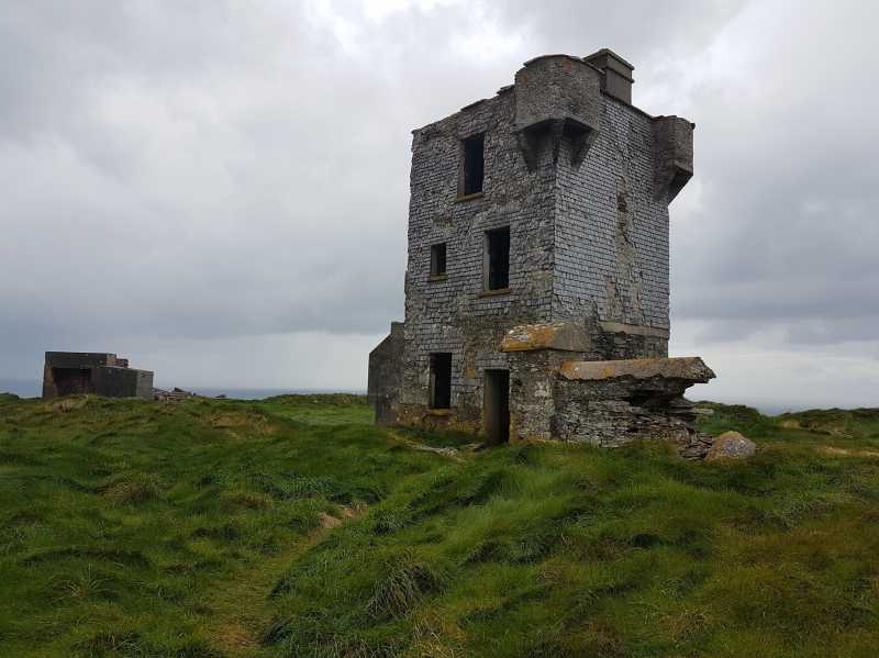
Excellent sea and coastal views on a clear day. . Acc to wiki, this was built in 1804 and 100 years later Marconi, who spent years in this area experimenting on telegraph communication, moved the equipment to this point too.
Apparently the station was destroyed by the IRA during the War of Independence. The actual summit appears to be in the middle of a thick clump of furze and briars, so whether one needs to stand on it depends on how OCD one is about these matters.
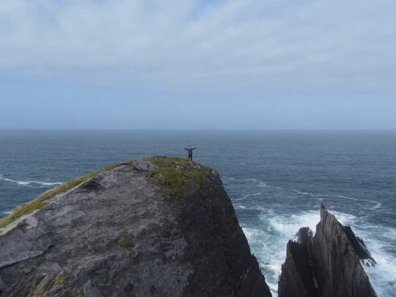
Picture: King of the world.....well the South of Ireland anyway.
As far South as mainland Ireland goes
by TommyV
30 Oct 2018
Some people mistakenly think the more famous Mizen head is the most Southerly point in Ireland, but it's actually the much lesser visited Brow Head. This is a short walk out to as far south as you can go on the mainland and has some spectacular views, and a dizzy walk to the very edge of Brow head if you are up for it. At the end of the hike it's possible to stroll a few hundred meters to an old signal tower sitting at the summit of the hill at A (V77746 23803). If staying in the area, a pint of stout in O'Sullivans in Crookhaven is a must followed by the Mediterranean fish soup in The Crookhaven Inn. Linkback: mountainviews.ie/summit/1375/comment/20115/
Use of MountainViews is governed by conditions and a privacy policy.
Read general information about the site. Opinions in material here are not necessarily endorsed by MountainViews.
Hillwalking is a risk sport. Information in comments, walks, shared GPS tracks or about starting places may
not be accurate for example as regards safety or access permission. You are responsible for your safety and your permission to walk.
See the credits and list definitions.


 Our Facebook page.