This website uses cookies, which are small text files that the website puts on your device to facilitate operation. Cookies help us provide a better service to you. They are used to track general user traffic information and to help the website function properly.
Feature count in area: 9, by county: Down: 5, Antrim: 4,
OSI/LPS Maps: 15, 20, 21
Highest Place: Divis 478m
Starting Places (2) in area Belfast Hills: Ballyherly Lough West, Castlemahon Mountain South East
Summits & other features in area Belfast Hills: E: Belfast Hills East: Cairngaver 217m, Ouley Hill 186m, Scrabo Hill 160m N: Belfast Hills North: Carnmoney Hill 231.1m, Cave Hill 368m, Divis 478m, Slievetrue 312m SE: Strangford & Portaferry: Ballywhite Hill 101m, Castlemahon Mountain 128m
Note: this list of places may include island features such as summits, but not
islands as such.
Castlemahon Mountain, 128mHill
Place Rating ..
, Down County in Ulster province, in Binnion Lists, Castlemahon Mountain is the 1495th highest place in Ireland. Castlemahon Mountain is the most southerly summit and also the second most easterly in the Belfast Hills area. It's also the second most easterly summit in Ireland.
Grid Reference J55588 47265,
OS 1:50k mapsheet 21 Place visited by: 18members, recently by: trostanite, Kirsty, Vfslb1904, dregish, Carolyn105, Fergalh, eamonoc, Ulsterpooka, LorraineG60, MichaelG55, AntrimRambler, Wilderness, sandman, Garmin, chalky
I visited this place: NO (You need to be a logged-in member for this.)
Short or GPS IDs, 6 char: CstlMn, 10 char: CstlmhMntn Linkback: https://mountainviews.ie/summit/1368/
Gallery for Castlemahon Mountain and surrounds
Summary
for Castlemahon Mountain :
A Strangford Lough balcony...
Summary created by Peter Walker
2014-08-29 21:12:47
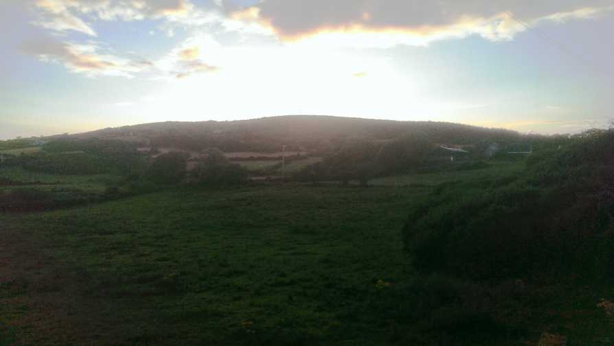
Picture: Castlemahon Mountain from the east at sunset
Castlemahon Mountain is the most significant eminence in the rolling County Down countryside to the south of Strangford Lough. Despite being tree-shagged and transmitter-crowned it is a relatively shy hill.
The most obvious points of access are from the minor road to the south. Start at (C'mahon SE (J563 470)) and walk up the concreted road heading northwards. This curves left through a courtyard surrounded by farmhouses and other agricultural buildings; permission does not seem to be a problem but it would be polite to enquire. From here a 4 wheel drive track continues on uphill; this is to provide access to the transmitter. You will pass a statue on the left; just after this go left at a junction up through an avenue of trees. The mast is on the right at the top of this rise, and the highest point is somewhere in the tough vegetation on its far side (no trig column has been found as of yet). The view is mostly curtailed by trees but is very fine in the directions in which it is open.
Looking at the map an even shorter route seems to suggest itself from (A (J559 469)), but enquiries at the cottage at the top of the track that leaves the road here suggested that the owner of the land (who lives at the first bungalow on the left on the way up, but was absent when I went knocking) would probably not allow access.
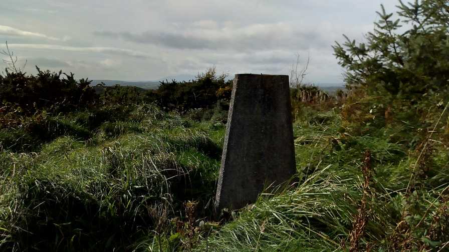
I followed Peter Walkers route and asked permission to walk to the summit mast. The person was very friendly and accommodating. I parked at the last house in what is a four house dwelling lane. The second last house has 'Joe' in centre of the metal gate. I assume a reference to Joe's mountain on a stone Boulder further up. I followed the track until the mast and found the trig pillar nearby. The Mourne mountain range can be seen as well as Strangford Lough and the Isle of Man on a good day. Linkback: mountainviews.ie/summit/1368/comment/19749/
Use of MountainViews is governed by conditions and a privacy policy.
Read general information about the site. Opinions in material here are not necessarily endorsed by MountainViews.
Hillwalking is a risk sport. Information in comments, walks, shared GPS tracks or about starting places may
not be accurate for example as regards safety or access permission. You are responsible for your safety and your permission to walk.
See the credits and list definitions.


 Our Facebook page.