This website uses cookies, which are small text files that the website puts on your device to facilitate operation. Cookies help us provide a better service to you. They are used to track general user traffic information and to help the website function properly.
Feature count in area: 28, all in Mayo,
OSI/LPS Maps: 22, 23, 30, 31, CBW, EW-ACC, EW-WNN, EW-WNS
Highest Place: Slieve Carr 721m
Starting Places (24) in area Nephin Begs: Altnabrocky Adirondack Shelter, Bellanaderg Bridge, Brogan Carroll Bothy, Bunnahowna Bridge, Bunnahowna River, Burrishoole Loop, Cloondaff Church, Deel River, Furnace Lough E, Glasheens River, Glendahurk Bridge, Glennamong Bridge, LFeeagh E Treenbeg Cottage, LFeeagh E Treenbeg School Ruin, Lough Avoher Hut, Lough Feeagh, Lough Gall NW Mayo, Loughanawillan Loughs Track, Mulranny Post Office, R312 Boghadoon, R312 Prughlish, Srahduggaun, Tarsaghaunmore River, Wild Nephin Wilderness
Summits & other features in area Nephin Begs: Cen: Glennamong: Bengorm 582m, Bengorm NW Top 468m, Corranabinnia 716m, Corranabinnia SW Top 687m, Glennamong 628m, Glennamong East Top 415m, Tirkslieve 401m Cen: Nephin Beg: Aroher Hill 285m, Lettertrask 279m, Nephin Beg 627m, Nephin Beg South Top 410m E: Birreencorragh: Birreencorragh 698m, Birreencorragh South Top 564m, Birreencorragh West Top 551m, Buckoogh 588m, Bullaunmore 388m, Knockaffertagh 517m, Mount Eagle 427m, Srahmore 186m, Srahrevagh North 282m NW: Slieve Carr: Bunmore 243m, Sheeanmore 282m, Slieve Alp 329m, Slieve Carr 721m, Tawnyanruddia 531m SW: Maunthomas: Claggan Mountain NE Top 501m, Maumthomas NE Top 440m, Maumthomas SW Top 477m
Note: this list of places may include island features such as summits, but not
islands as such.
Corranabinnia SW Top, 687mMountain Coire na Binne (mullach thiar theas) A name in Irish,
Place Rating ..
For origin of name, see Corranabinnia., Maol Rua, Sliabh Thomaas, Mayo County in Connacht province, in Arderin, Vandeleur-Lynam, Irish Best Hundred Lists, Corranabinnia SW Top is the 135th highest place in Ireland.
Grid Reference F89770 02618,
OS 1:50k mapsheet 30 Place visited by: 182members, recently by: ochils_trekker, DarrenY, keith.dillon, NualaB, nupat, rhw, mdehantschutter, Magic, Carolineswalsh, srr45, ToughSoles, Kaszmirek78, abeach, SeanPurcell, JohnHoare
I visited this place: NO (You need to be a logged-in member for this.)
Short or GPS IDs, 6 char: CrnbSW, 10 char: CrnbnSWTp Linkback: https://mountainviews.ie/summit/134/
Gallery for Corranabinnia SW Top (Coire na Binne (mullach thiar theas)) and surrounds
Summary
for Corranabinnia SW Top (Coire na Binne (mullach thiar theas)):
Excellent Ridge Walk with Scrambling
Summary created by Geo, Onzy
2019-06-04 08:39:34
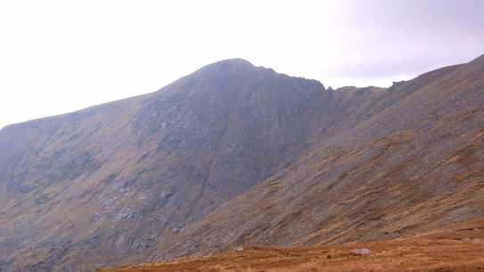
Picture: Ridge to Corranabinnia from west of the summit
The attraction, and the high rating, of Corranabinnia SW top is largely in the fine ridge which extends north east to its main peak. The summit itself is at the east end narrow grassy plateau oriented east to west. Views are good in all directions, particularly over Clew Bay to the south.
Corranabinnia SW top is remote from roads and consequently there are a relatively small number of practical routes and most of these involve other peaks. However, an up and down route could be made using the spur heading south from the summit, parking around Gl'dHurk Brg (L91061 97962). Around 2-3 hours.
The most obvious circuit is that of Glendahurk Valley, taking in Bengorm, its NW top and the 2 Corranabinnias and making use of the raking spur south of Corranabinnia SW top. The horseshoe can be done in either direction, from the starting point above or about 300m further south, where there is a stile on the right. At 15k with an ascent of c.1,000m, the circuit should take about 6 hours.
A more ambitious circuit starting further east in the vicinity of Srahmore and centering on the Glennamong Valley is also possible. This would take in Tirkslieve, both Glennamongs, Corranabinnia, an out and back extension to Corranabinnia SW top and the two Bengorms, before descending to the road near Furness. This is a walk of 22k+, with some road walking and will take about 8 hours.
Add a Place Comment for Corranabinnia SW Top, Coire na Binne (mullach thiar theas) (134) in Area: Nephin Begs, Cen: Glennamong, County: Mayo, Cen: Glennamong
Member Comments for
Corranabinnia SW Top (Coire na Binne (mullach thiar theas))
Picture: Looking west on the descent from Maol Rua, towards Greenaun mountain, Corraun and Clare Island
New Maol Rua - a lot of reward for a moderate challenge
by ochils_trekker
Fri 26 Jul
I had visited Corranabinnia itself on a previous occasion, ascending via Ben Gorm, and had resolved to re-visit as it is such a beautiful valley (Glendahurk). It is also probably the most easily accessible of all the Nephin Beg range as a car can be taken to within a few hundred yards of the mountain itself, up a fairly decent off-road track and parked up just before the bridge, next to a small farm building.
The walk was itself a lot more easy going underfoot than the approach to its sister hill across the valley. Simply go through the gate and across the river, then carry on following the path past the turning on the left and up a few hundred yards to the point where the track runs out. Then it is a matter of just picking one's way up through the mix of heather, boulders, larger rocks and turf with the occasional shallow peat hag to negotiate. A delightful and steady ascent with great views both sides and in front as the precarious-looking ridge between the two tops comes into view later in the climb. There are also impressive outlooks across past the most SW tops in the Nephin Begs - Maumthomas and Greenaun - and out towards Corraun , Achill Island and Clare Island beyond, if the weather is kind to you. On the final push from the shoulder, I kept away from the steep east face, more to save spooking the timid sheep (which shows how relatively unwalked the Nephin Begs are compared to some other ranges )and forcing them towards the edge, than anything else, as the conditions were gentle with only a light breeze and good visibility. I was at the top comfortably in couple of hours, and enjoyed a leisurely lunch in perfect peace before having a wander around the extensive summit plateau to get more view points around these splendid mountains and their vast hinterland of north Mayo bogs and loughs. Linkback: mountainviews.ie/summit/134/comment/24245/
Read Less
Read More
From the Northwest
by Geo
4 Jun 2019
As per Peter1's comment and his uploaded track no 3472 (Many thanks Peter1) an approach from the NW from the end of a boreen at 'Blue Lodge' SraDug (F866 072) may be attempted.
June 1st 2019 millsd1 and myself crossed the Shannon and made our way fortified by bacon and sausage sandwiches in Castlebar and thence to the end of said boreen. Our general plan was to tackle a circuit which involved the two Corranbinnias and Glennamong with track 3472 as our guide but doing it CW rather than ACW as our quest for VL glory continues apace.
As of June 2019 however the footbridge across the brook opposite the said Blue Lodge (parking for 3 or 4 cars) had been destroyed in January 2019, according to a local fisherman we encountered This means that one has to go further South and take a wider circuit than Peter's track to circumvent the many streams that come down from the coums and hillsides and this makes doing the circuit ACW much more practical. Peter1's warning that the bog should be crossed with care is well warranted. While it is generally easy going there are many areas of 'floating bog' which need to be traversed with extreme care as the underlying depth to solid ground is unknown and likely to be capable of swallowing an adult human! So leave it for good weather with a period of good weather beforehand is my advice. Once bog is crossed and when one reaches the spur at A (F894 038) it is a relatively easy climb to the top.
We then continued across the arrete (which interestingly is a propriety brand of stool thickener and perhaps required if you haven't a head for airy heights) on the Corranbinnia summit, thence to Glennamong and back down to the bog, at which point we could not directly return to car due to the bridge being out and had to do a large dog-leg west to cross a number of streams high enough up before they became unfordable and then turned North and continued across quaking bogs circumventing little ponds to return to car, All in all a 6.5 hour adventure. Linkback: mountainviews.ie/summit/134/comment/20541/
Read Less
Read More
Picture: Sw top as seen from ridge to Ben Gorm
gerrym on Corranabinnia SW Top
by gerrym
1 Jan 2006
I approached the SW top from Corranabinnia itself and it is a quick drop down to the col. The route to the summit of the SW top looks pretty difficult - it can be if you want but there are easy paths just below the rocks at its crest. Nevertheless this was an exciting diversion from the walking for most of the day, hands are needed and if you want the exposure you can have it with big drops, especially to the N into the corrie containing Corranabinna Lough. As Simons pic shows there are fantastic views, with the great contrast of the lowlands and the Nephins rising steeply from the bogs. There are again stunning views from the broad level top, with the expanses of water dotted with islands drawing the eye. There is a long and gradual ridge heading off to the S along Glendahurk which would be a good alternative approach . I retraced my steps, which was fun again, back to the top of Corranabinnia where i had left my rucksack and then headed along the ridge to Ben Gorm. Linkback: mountainviews.ie/summit/134/comment/1916/
Read Less
Read More
simon3 on Corranabinnia SW Top
by simon3
17 May 2007
Robert Lloyd Praeger [The Way that I Went] said of the Nephin Begs “Where else even in Ireland will you find 200 square miles which is houseless and roadless – nothing but brown heather spreading as far as the eye can see, and rising along a kind of central back-bone into high bare hills breaking down here and there in rocky scarps, with the Atlantic winds singing along their slopes? I confess I find such a place not lonely or depressing by inspiriting.” Could any of us attempt to put it better?
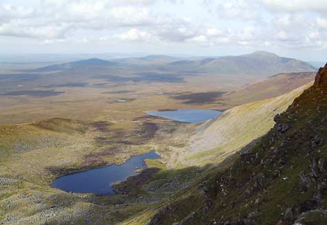
Our photo, taken from near the top of Corranabinnia SW Top, shows much of the bare bog. The nearer water is Lough Corranabinnia, while further there is the west end of the remote double lake, over 1 km in length, that is Corryloughaphill Lough, with the slopes of Glennamong rising immediately beyond it. On the skyline at the right is Nephin Beg. Centrally, just touching the skyline is that most unusually named mountain “Slieve Alp” (329m).
One note of navigational caution. The OS 1:50k shows a spot height 681. This is not the highest point on the ridge which is around 370m to the east. As of May 2007 there is no cairn or other mark at the highest point. If you mistake this in mist you could go seriously wrong for example in attempting to get onto the southern ridge. Linkback: mountainviews.ie/summit/134/comment/624/
Read Less
Read More
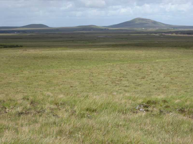
Picture: Extensive blanket bog of the Nephin range
Mad for Bog!
by peter1
5 Jun 2017
Under the best weather/soil moisture conditions, an approach from the West is very feasible. Starting and finishing at the road head at Srahduggaun, SraDug (F86585 07217), a long (5k or so) walk across spongy sphagnum and short grass and heather brings you to the ridge running North from the Corrannabinnia SW plateau. A fine high level walk following the ridge brings you to Glenamong and from there, pick your route back to the start - there's plenty of scope! One word of caution - be careful crossing the boggy areas with the really bright green grass on the return, they may be really deep! Linkback: mountainviews.ie/summit/134/comment/19540/
Use of MountainViews is governed by conditions and a privacy policy.
Read general information about the site. Opinions in material here are not necessarily endorsed by MountainViews.
Hillwalking is a risk sport. Information in comments, walks, shared GPS tracks or about starting places may
not be accurate for example as regards safety or access permission. You are responsible for your safety and your permission to walk.
See the credits and list definitions.


 Add a Place Comment for Corranabinnia SW Top, Coire na Binne (mullach thiar theas)


 Our Facebook page.