Members and Supporters, the MountainViews Committee requests your help to meet the costs of the website and of other activities such as insured events or publications.
Feature count in area: 12, all in Mayo,
OSI/LPS Maps: 30, 31, 37, 38, CBE, CBW, MSW
Highest Place: Croagh Patrick 764m
Starting Places (19) in area Croagh Patrick: Balloor, Ben Goram Road, Bracklagh, Carrowmore Hill South, Carrowrevagh Lough, Cregganbaun, Keelkill North, Kilgeever Wood, Killeennimat Burial Ground, Kinknock, Laghta Eighter, Laghta Eighter Hill NE, Murrisk Fishermans Monument, National Famine Memorial, Old Head, Paddy's Place, Prospect Lough Road, Sruhaunpollanoughty, St Patricks Church
Summits & other features in area Croagh Patrick: N: North Ridge: Ben Goram 559m, Boheh Hill 219m, Croagh Patrick 764m, Crott Mountain 500m, Lugnademon 510m, Teevenacroaghy 487m S: Owenmore: Carrowrevagh 210m, Knockakishaun 390m, Oughty Hill 333m W: Louisburgh Hills: Balloor Hill 147m, Carrowmore Hill 171m, Kinknock Hill 173m
Note: this list of places may include island features such as summits, but not
islands as such.
Carrowmore Hill, 171mHill
Place Rating ..
, Caramor Hill, Mayo County in Connacht province, in Binnion Lists, Carrowmore Hill is the 1445th highest place in Ireland. Carrowmore Hill is the most westerly summit and also the second most northerly in the Croagh Patrick area.
Grid Reference L78314 80895,
OS 1:50k mapsheet 30 Place visited by: 12members, recently by: markmjcampion, conormcbandon, Fergalh, eamonoc, oakesave, Jamessheerin, sandman, Garmin, hivisibility, chalky, mcrtchly, kernowclimber
I visited this place: NO (You need to be a logged-in member for this.)
Short or GPS IDs, 6 char: CrwmHl, 10 char: CrwmrHil Linkback: https://mountainviews.ie/summit/1328/
Gallery for Carrowmore Hill and surrounds
Summary
for Carrowmore Hill :
An easy summit
Summary created by mcrtchly
2014-06-03 13:46:10
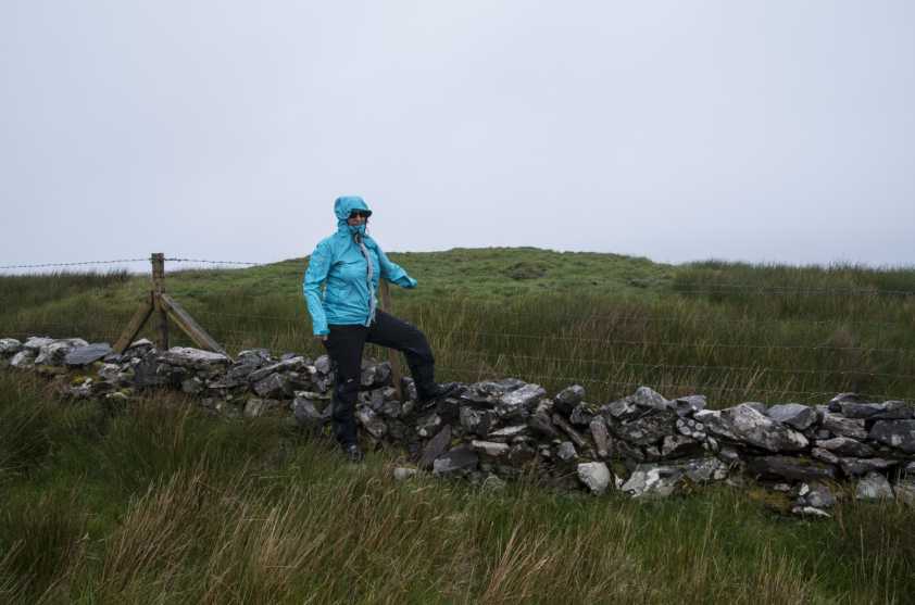
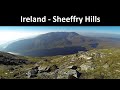
Picture: The underwhelming summit of Carrowmore Hill
This is an easy summit to climb from the south. Park on the verge opposite a house just after turning onto a minor road from the road which runs along the south side of the hill (C'mor Hl S (L78505 80469)). Walk back to main road, turn left and pass through a gate to access the second field on the right. There is a steep climb across the field to a narrow break through the gorse line. Continue to the top left corner of the field, cross a fence on your left. The summit is about 70m further on just north of another fence. Total time to top and back is less than an hour. The summit should have good views across Clew Bay (if it is not misty).
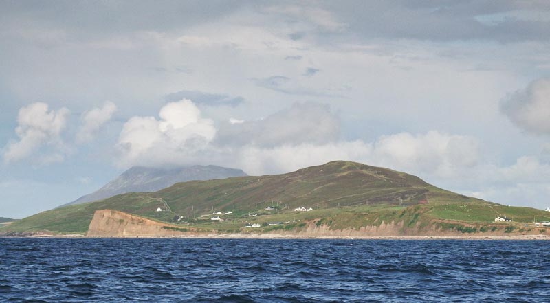
Perhaps Carrowmore's best face is towards the sea. This picture shows the place from a boat out of Roonagh Pier.
Looming behind Carrowmore is Croagh Patrick. Linkback: mountainviews.ie/summit/1328/comment/17537/
Use of MountainViews is governed by conditions and a privacy policy.
Read general information about the site. Opinions in material here are not necessarily endorsed by MountainViews.
Hillwalking is a risk sport. Information in comments, walks, shared GPS tracks or about starting places may
not be accurate for example as regards safety or access permission. You are responsible for your safety and your permission to walk.
See the credits and list definitions.


 Our Facebook page.