Cookies.
This website uses cookies, which are small text files that the website puts on your device to facilitate operation. Cookies help us provide a better service to you. They are used to track general user traffic information and to help the website function properly.
Features
Nearby features appear when you click the map.
Declutter tracks on map.
Place Search
Video
X
Pub: by
Belfast Hills Area , E: Belfast Hills East Subarea
Feature count in area: 9, by county: Down: 5, Antrim: 4, OSI/LPS Maps: 15, 20, 21
Highest Place: Divis 478m

Starting Places (2) in area Belfast Hills:
Ballyherly Lough West, Castlemahon Mountain South East

Summits & other features in area Belfast Hills:
E: Belfast Hills East: Cairngaver 217m, Ouley Hill 186m, Scrabo Hill 160m
N: Belfast Hills North: Carnmoney Hill 231.1m, Cave Hill 368m, Divis 478m, Slievetrue 312m
SE: Strangford & Portaferry: Ballywhite Hill 101m, Castlemahon Mountain 128m

Note: this list of places may include island features such as summits, but not islands as such.
Rating graphic.
Ouley Hill, 186m Hill
Place Rating ..
, Down County in Ulster province, in Binnion Lists, Ouley Hill is the 1422th highest place in Ireland.
Grid Reference J38322 62605, OS 1:50k mapsheet 20
Place visited by: 22 members, recently by: Jai-mckinney, Oscar-mckinney, eflanaga, trostanite, Kirsty, Vfslb1904, dregish, Carolyn105, Fergalh, eamonoc, NICKY, LorraineG60, MichaelG55, Wilderness, sandman
I visited this place: NO (You need to be a logged-in member for this.)
Longitude: -5.866062, Latitude: 54.493004, Easting: 338322, Northing: 362605, Prominence: 110m,  Isolation: 13.8km, Has trig pillar
ITM: 738240 862602
Bedrock type: Sandstone, (Gala Group)

  Short or GPS IDs, 6 char: OlyHl, 10 char: Ouley Hill

Linkback: https://mountainviews.ie/summit/1310/
Gallery for Ouley Hill and surrounds
No summary yet for this place .
Member Comments for Ouley Hill
Comment create / edit display placeholder

            MountainViews.ie picture about Ouley Hill
Picture: Nearing the high point on Ouley Hill
A cautionary tale !!
by Harry Goodman 15 Apr 2014
I first visited this hill two years ago and like Peter Walker noted the very persuasive signs to keep out. As the hill is now one of my Local 100 in the new mv listings I decided on 8 April 2014 to go and have another look. A call at the quarry site office confirmed there was no access from there. However noting a wind turbine up on the NW side of the hill I sought out the access track up and, with the owners permission, went up. At its crest and in the absence of any prohibitive signage I crossed the fence and climbed up over a newly planted out embankment.From its top I I was able to see I substantial vehicle track below me which curved around the lip of the quarry but was protected from it by a raised ditch with cautionary signs on it "Warning Deep Drop". In search of the highest point I followed the track around keeping the ditch on my left and an even higher embankment on my right. What soon became clear was that the recorded high point for this hill, as shown on the OS Sheet, and the Trig Pillar have long since been quarried out of existence. As a result the current high point now lies along the raised embankment running along the S side of the quarry above the track and well back from the quarry edge at A (J38234 62563) and at a height of 188m read from my basic Garmin e-trex GPS. I understand this high embankment around the W and S of the quarry has been constructed as a screen for local landowners to hide the ravages of the quarry and will, very shortly, be planted out with grass and trees/bushes. While there I was approached by a quarry employee, in a white 4x4 complete with flashing warning lights, who wanted to know why I was there and how I had gained access. After a brief discussion as to the how and why (summit bagging) he simply told me that the name of the hill was pronounced locally as "Aughley" and drove off. On my way back I noted that the track I was on was an extension of the track up from the road noted by Peter Walker at B (J380 625) and, if available, would lead up to the high point of the hill only 200m along. However it is currently barred by two gates denoting "Quarry Workings - Keep Out". Linkback: mountainviews.ie/summit/1310/comment/16008/
Read Less
Read More

            MountainViews.ie picture about Ouley Hill
Picture: Garrrgghhh! The summit may well be the top of that embankment...
Not quite touching the void...
by Peter Walker 26 Aug 2014
Here's another one for the 'what constitutes an ascent?' debate. The newly appointed Binnion of Ouley Hill is one of the nearest MV tops to our house, and was thus ideal for a quick Sunday late afternoon race with the gathering gloom. Inspection of the map suggested it to be a little more than a hop, step and a jump from the minor road cresting its western slope, and so hopes were high for neelix_tdog and myself.

The reality is somewhat different. The top of the hill is the site of a substantial quarry, and the track marked as leaving the road at (C (J380 625)) is soon blocked by substantial gates and proper 'we mean it' warning signs regarding trespass. Slightly further south at (D (J382 623)) another track heads east...by walking along this and nipping through an open gate a short way along and heading north, it's possible to walk up a field to reach a fence nigglingly JUST short of the apparent summit (about 5m in height, I reckon). Alas this fence is decorated with the same signage as the other approach (see photo...apologies for the blurring, but it was a bit windy) and as I was aware of the watching eyes of someone in the farmhouse at the bottom of the field I decided against going further.

Not one to give up that easily, I also explored the possibilities from the A7 to the east. This side doesn't seem very promising either, approaches seemingly under the control of the quarry company or a building firm.

So, have I ticked it? My conscience says no.

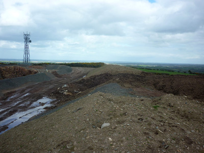
UPDATE 25/08/14. The summit IS the top of that embankment...double Garrrgghhh! But at least it's done now.

Other summit aspirants might wish to note that there is even more 'Keep Out' signage about now (I used Harry's route)...it may not be long before this hill is pretty much inaccessible. Linkback: mountainviews.ie/summit/1310/comment/15810/
Read Less
Read More

            MountainViews.ie picture about Ouley Hill
Birds
by Carolyn105 17 Nov 2020
This is a very quick simple tick. Lovely views on a clear day. Followed the advice below and couldn't go wrong Linkback: mountainviews.ie/summit/1310/comment/21297/
Read Less
Read More

            MountainViews.ie picture about Ouley Hill
Picture: The Fallen.
Sunday Morning.
by sandman 19 Oct 2015
The best time to access summits located within the boundary of quarries is on a Sunday morning and at the same time one should exercise extreme caution by KEEPING YOUR DISTANCE from the quarry face and machinery. With this in mind you can park at E (J38030 62497) cross over three gates and within minutes you will be at the high point the original summit been long gone. The mast in Harry's photo now lies on its side adjacent to the high point. Linkback: mountainviews.ie/summit/1310/comment/18359/
Read Less
Read More
EDIT Point of Interest
text
Videos

Recent Contributions
x
Conditions and Info
Use of MountainViews is governed by conditions and a privacy policy.
Read general information about the site.
Opinions in material here are not necessarily endorsed by MountainViews.
Hillwalking is a risk sport. Information in comments, walks, shared GPS tracks or about starting places may not be accurate for example as regards safety or access permission. You are responsible for your safety and your permission to walk.
See the credits and list definitions.

OSi logo
OSNI/LPS logo
Open Street Map
(Various variations used.)
British summit data courtesy:
Database of British & Irish Hills