Cookies. This website uses cookies, which are small text files that the website puts on your computer to facilitate operation. Cookies help us provide a better service to you. They are used to track general user traffic information and to help the website function properly.

Click to hide this notice for 30 days.
Welcome to MountainViews
If you want to use the website often please enrol (quick and free) at top right.
Overview
Detail
Zoom: ??
For more map options click on any overview map area or any detail map feature.
Detail Map Features
Showing 2 items:
Lugganammer 190m,
Tracks:
3277, 0km
Find Suggested Walks
Find hill, mountain, island, coastal feature.
Videos
(none available)
Recent Contributions
Get Notifications

Fair Mountain: Spiky forest

Fair Mountain: Flattish spur south of the Wicklow Gap, cliffy to the north.

Broaghnabinnia: Lung bursting ascent of Broaghnabinnia

The mighty Slioch (The Spear)

Carrauntoohil: A Night Climb of Carrauntoohill

Slioch: Tough going above Loch Maree

Tinahely Hill: View from the North East.

A very tough outing in Glen Etive

Meall nan Eun: Gentle slopes lead to this Munro

Stob Coir'an Albannaich: A fine cliff top Summit in Glen Etive

Glas Bheinn Mhor: One of Glen Etive's finest

Access via rocky trail

Conditions and Info
Use of MountainViews is governed by conditions and a privacy policy.
Read general information about the site.
Opinions in material here are not necessarily endorsed by MountainViews.
Hillwalking is a risk sport. Information in comments, walks, shared GPS tracks or about starting places may not be accurate for example as regards safety or access permission. You are responsible for your safety and your permission to walk.
See the credits and list definitions.
Video display
North East Midlands Area   NW: Aughavas Subarea
Place count in area: 24, OSI/LPS Maps: 26, 27, 27A, 28, 28A, 28B, 34, 35, 36, 41 
Highest place:
Cornasaus, 339m
Maximum height for area: 339 metres,     Maximum prominence for area: 224 metres,

Places in area North East Midlands:
Cen: Ballyjamesduff:   Aghalion Hill 249m
Cen: Oldcastle:   Mullaghmeen 258mSlieve Na Calliagh 276mSpire of Lloyd 131mThe Hill of Mael 241m
E: Kingscourt:   Carrickleck Hill 173m
N Cen: Cavan Town:   Shantemon 218mSlieve Glah 320mTievenanass 261m
NE: Ballybay:   Bunnanimma 268m
NE: Carrickmacross:   Corduff 243m
NE: Castleblaney:   Mullyash Mountain 317m
NE: Cen Bailieborough:   Cornasaus 339mTaghart South 290m
NW Cen: Arva:   Bruse Hill 260m
NW: Aughavas:   Lugganammer 190m
S Cen: Crookedwood:   Cruckboeltane 199mKnockeyon 214m
S: Westmeath South West:   Knockastia 200m
SE: Boyne Valley:   Hill of Slane 160.4mMount Oriel 251mTara 155m
W: Ardagh:   Bawn Mountain 200m
W: Drumlish:   Corn Hill 278m

Note: this list of places includes island features such as summits, but not islands as such.
Rating graphic.
Lugganammer Hill Leitrim County in Connacht Province, in Binnion List, Blue-grey greywacke & black argillite Bedrock

Height: 190m OS 1:50k Mapsheet: 34 Grid Reference: N18796 98186
Place visited by 13 members. Recently by: TommyMc, melohara, conormcbandon, jackill, Bernieor, madfrankie, Garmin, wicklore, eamonoc, paddyhillsbagger, Geo, sandman, Fergalh
I have visited this place: NO (You need to be a logged-in member to change this.)

Longitude: -7.714595, Latitude: 53.932784 , Easting: 218796, Northing: 298186 Prominence: 135m,  Isolation: 12.9km,   Has trig pillar
ITM: 618742 798197,   GPS IDs, 6 char: Lgnmr, 10 char: Luganamer
Bedrock type: Blue-grey greywacke & black argillite, (Finnalaghta Formation)

Lugganammer is the 1413th highest place in Ireland.

Linkback: https://mountainviews.ie/summit/1304/
COMMENTS for Lugganammer 1 of 1  
Follow this place's comments
Lovely Leitrim
Short Summary created by Geo  23 Mar 2014
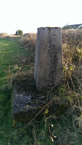
Simple summit, Driveable to top. The trig point is in a field, about a metre or so inside the hedge/fence with the public road.
Simple access from R201 Carrigallen to Mohill road. About 7km from Carrigallen, at a sign to the right for Aughavas, turn right here. Pass Aughavas church, then primary scholl on the right hand side, then after a thatched cottage on the right, a junction with a minor road going right, follow this minor road broadly South (narrow road, grass on centre, lots of bends so take your time). Go straight thru at a crossroad where you are asked to yield. When you reach concrete water reservoir (has wind vane and solar panels on top), pull over to the left as you can park your car here off the road, you are about 4km from R201.
The trig pillar is just beyond the reservoir in the field and almost touchable across the fence from the road (no need to cross into private field) at N1879798186 starA.
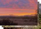
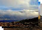
If you look behind at this point i.e. North, you can see the breadth of the Breifne range, Iron Mountains, Cuilcagh, and Slieve Rushen, and these are even more visible as you return by road the way you came.
Simple bag, park, exit car, and well you're there! Linkback: https://mountainviews.ie/summit/1304/comment/15548/
 
Shortest climb ever
by Fergalh  1 Feb 2014
After Cloone on the Carrigallen road take the third turn right. At the second crossroads turn left until T junction turn right and continue up hill to water tower (N1864298161 starB). The trig point is one metre inside fence here, not exactly a long walk ! Linkback: https://mountainviews.ie/summit/1304/comment/15799/
Your Score: Very useful <<  >>Average
 
MountainViews.ie Picture about mountain Lugganammer  in area North East Midlands, Ireland
Picture: Summit Trig
 
Leitrim Hill
by sandman  11 Mar 2014
Situated between substation and private house ...hill baggers only Linkback: https://mountainviews.ie/summit/1304/comment/15912/
Your Score: Very useful <<  >>Average
 
(End of comment section for Lugganammer .)

OSi logo OSNI/LPS logo
Some mapping:
Open Street Map
(Various variations used.)
British summit data courtesy:
Database of British & Irish Hills
(Creative Commons Licence)
MountainViews.ie, a Hill-walking Website for the island of Ireland. 2300 Summiteers, 1460 Contributors, Newsletter since 2007