This website uses cookies, which are small text files that the website puts on your device to facilitate operation. Cookies help us provide a better service to you. They are used to track general user traffic information and to help the website function properly.
Feature count in area: 27, all in Antrim,
OSI/LPS Maps: 14, 15, 4, 5, 8, 9
Highest Place: Trostan 550m
Starting Places (3) in area Antrim Hills: Donalds Carn, Rathlin Island Ferry Port, Whitehead Golf Club
Summits & other features in area Antrim Hills: Cen: Central Antrim Hills: Carncormick 436m, Collin Top 429m, Crockalough 402m, Mid Hill 440m, Skerry Hill 459m, Slieveanorra 508m, Slievenahanaghan 418m, Soarns Hill 403m, Tievebulliagh 402m, Trostan 550m Central Antrim Hills: Slievenanee 543m N: North Antrim Hills: Carnanmore 379m, Croaghan 417m, Crockaneel 403m, Cross Slieve 206m, Knocklayd 514m, Lannimore Hill 207m N: Rathlin Island: Kilpatrick (Rathlin Island) 134m S: Islandmagee: Donalds Carn 141m, Muldersleigh Hill 131m S: South Antrim Hills: Agnew's Hill 474m, Big Collin 353m, Black Hill 381m, Carnearny 319m, Douglas Top 402m, Slemish 437.9m W: West Antrim: Long Mountain 215m
Note: this list of places may include island features such as summits, but not
islands as such.
Lannimore Hill, 207mHill
Place Rating ..
, Antrim County in Ulster province, in Binnion Lists, Lannimore Hill is the 1387th highest place in Ireland. Lannimore Hill is the second most northerly summit and also the second most westerly in the Antrim Hills area.
Grid Reference D04331 43252,
OS 1:50k mapsheet 5 Place visited by: 19members, recently by: Paddym99, garybuz, Claybird007, dregish, Hoverla, trostanite, Kilcoobin, eamonoc, eejaymm, NICKY, Wilderness, Ulsterpooka, sandman, chalky, Garmin
I visited this place: NO (You need to be a logged-in member for this.)
Short or GPS IDs, 6 char: LnmrHl, 10 char: LnmrHil Linkback: https://mountainviews.ie/summit/1282/
Gallery for Lannimore Hill and surrounds
Summary
for Lannimore Hill :
Not much going for it.
Summary created by Harry Goodman
2014-07-31 16:33:06
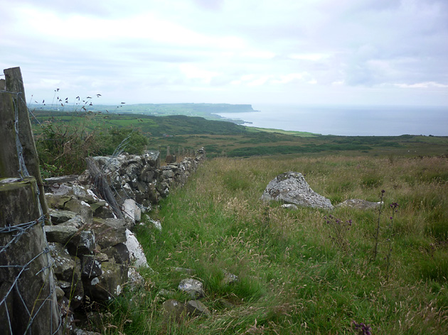
Picture: Looking NW to Benbane Head from the top of Lannimore Hill
Park with consideration at the entrance to a track just beyond (NW) the junction of Maghery Road and Ballinalea Road A (D04200 42650). Walk back to the road junction and a few metres along Maghery Road, on the left, take a gated track and follow it up past a communications mast to another gate and out on to the open hillside. vere left to cross another gate and keeping the raised ditch/fence line to the left follow it up to the high point of the hill at a fence junction B (D04335 43252). While there are nice views down to and along the Causeway Coast as far as Benbane Head and SE to Knocklayd there is not much more to say about this top. Really only one for the summit bagger, otherwise not worth the effort. Approximately 2km out and back.
Park just after junction at entrance to telecommunications tower (C (D04348 42554)) walk past tower to field behind turn left to high point at end of field. Linkback: mountainviews.ie/summit/1282/comment/16052/
Read Less
Read More
A nice walk
by Wilderness
29 Jan 2017
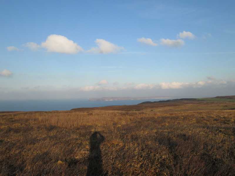
You can park at the south side of Lannimore Hill ; close to where the Ballinlea and Maghery roads meet: D (D042 426). Wanting to do a longer walk I parked at Ballintoy and walked the wildest way up ,(the north side very close to the bauxite mine). There a few tractor tracks to follow up and then onto some marshy fields before reaching the top ; I don't really recommend this way! After observing the nice views of the Giants Causeway and Rathlin Island I went south down to the Ballinlea road and walked back to Ballintoy. Linkback: mountainviews.ie/summit/1282/comment/18836/
Use of MountainViews is governed by conditions and a privacy policy.
Read general information about the site. Opinions in material here are not necessarily endorsed by MountainViews.
Hillwalking is a risk sport. Information in comments, walks, shared GPS tracks or about starting places may
not be accurate for example as regards safety or access permission. You are responsible for your safety and your permission to walk.
See the credits and list definitions.


 Our Facebook page.