Cookies.
This website uses cookies, which are small text files that the website puts on your device to facilitate operation. Cookies help us provide a better service to you. They are used to track general user traffic information and to help the website function properly.
Features
Nearby features appear when you click the map.
Declutter tracks on map.
Place Search
Video
X
Pub: by
Achill & Corraun Area , NW: Croaghaun Subarea
Feature count in area: 16, all in Mayo, OSI/LPS Maps: 22, 30, CBW, EW-ACC, EW-ACC
Highest Place: Croaghaun 688m

Starting Places (16) in area Achill & Corraun:
Achillbeg Island, Achillbeg Mid West Beach, Barneygappul Strand, Belfarsad Bridge, Breanaskill, Bunanioo Church, Cartron River, Clare Island, Doogort Beach, Fiodián na Circe, Keem Bay, Lough Acorrymore, Lough Gall, Minaun Mast, Rossnafinna Island, Tobercolman Cross Cemetery

Summits & other features in area Achill & Corraun:
Cen: Minaun: Minaun (Achill Island) 466m
N: Slievemore: Krinnuck (Achill Island) 214m, Slievemore (Achill Island) 671m
NW: Croaghaun: Benmore (Achill Island) 332m, Cornaclea Hill (Achill Island) 269m, Croaghaun (Achill Island) 688m, Croaghaun SW Top (Achill Island) 664m
S: Knockmore Achill: Achillbeg Island N Top (Achillbeg Island) 109.7m, Achillbeg Island S Top (Achillbeg Island) 108.5m, Knockmore (Achill Island) 337m, Tievereivagh (Achill Island) 286m
SE: Corraun: Knocklettragh 452m, Corraun Hill 524m, Corraun Hill Highpoint 541m
SW: Clare Island: Knockmore (Clare Island) 462m, Knocknaveen (Clare Island) 223m

Note: this list of places may include island features such as summits, but not islands as such.
Rating graphic.
Croaghaun, 688m Mountain Cruachán A name in Irish,
Place Rating ..
(Ir. Cruachán [logainm.ie], 'little stack'), Mayo County in Connacht province, in Arderin, Vandeleur-Lynam, Irish Best Hundred, Irish Highest Hundred, Irish Islands Lists, Croaghaun is the highest mountain in the Achill & Corraun area and the 132nd highest in Ireland.
Reachable "On Foot " Y
Grid Reference F55960 06092, OS 1:50k mapsheet 22/30
Place visited by: 370 members, recently by: RonanS, maryblewitt, Dee68, garybuz, Paddym99, DSutherland, farmerjoe1, keith.dillon, benjimann9, Padraigin, AntrimRambler, rhw, taramatthews, Magic, Carolineswalsh , Island visited by 565 members.
I visited this place: NO (You need to be a logged-in member for this.)
, I visited this island: NO
Longitude: -10.196544, Latitude: 53.984094, Easting: 55960, Northing: 306092, Prominence: 688m,  Isolation: 0.7km
ITM: 455941 806104
Bedrock type: X-bedded psammites and schists, (Croaghaun Formation)
Notes on name: It was the tradition for local children to pick berries on the mountain on the last Sunday of July, known locally as Garlic Sunday (apparently a corruption of 'garland') (MacNeill, 191). Walks: for a cliff-top walk near Achill Head, see Siúlóidí Acla, walk A. Previously Tonacroaghaun in MV.
  Short or GPS IDs, 6 char: Crghn, 10 char: Croaghaun

Linkback: https://mountainviews.ie/summit/127/
Gallery for Croaghaun (Cruachán) and surrounds
Summary for Croaghaun (Cruachán): An awe-inspiring coastal peak presiding over rugged sea cliffs.
Summary created by markmjcampion, scapania 2021-03-14 11:35:48
            MountainViews.ie picture about Croaghaun (<em>Cruachán</em>)
Picture: Croaghaun from Achill Head
Croaghaun is the distinctive high point on a rugged, steep-sided coastal ridge which can be followed to sea level at Achill Head. Massive cliffs abound in this area and there is plenty of varied terrain to make for a most interesting massif. but utmost care needs to be taken in wind or mist. Views are incredible including the local cliffs, cols and loughs as well as Slievemore, Belmullet and the Nephins.

S. Park at beautiful Keem strand Keem (F56122 04379) and head W to pick up the ridge which can be followed to Benmore, walking above fine sea cliffs as you go. If not taking the detour to Achill Head, drop down to A (F54624 05171) from where a minor track will take you steeply up through the heather and grass slopes of the SW top. From here it's an easy walk to Croaghaun with terrific views opening up to the NW. 2.5hrs+ A possible return is to follow the SE ridge to SH 474 and steeply S from here to Keem.

E. Park at L Acor (F57870 05759) and head clockwise around the lake briefly, breaking off before the first corry to ascend due W on good ground to spot height 474, From here head steeply NW to gain the summit. 1.5hrs

E. Get to the saddle on the W of Cornaclea B (F59544 07259) either by walking from Dooagh or from the Deserted Village. From here follow the obvious ridge up to C (F57505 07445) from where the awesome Lough Bunnafreva comes into view. Veer S from here and snake your way to the summit revelling in the stupendous views as you go.

Noteable tracks include track/3820 and track/1774
Linkback: mountainviews.ie/summit/127/comment/4887/
Member Comments for Croaghaun (Cruachán)

            MountainViews.ie picture about Croaghaun (<em>Cruachán</em>)
Picture: Saddle Head from the cliffs west of Croaghaun
Croaghaun from Keem Strand via Benmore Cliffs
by kernowclimber 14 Apr 2010
Croaghaun, a giant slumbering on the western end of Achill Island is not a mountain to be taken lightly. Indeed, everything in this remote part of Ireland seems to be on an epic scale: the cliffs, mountains and views. We parked at Keem Strand above a pristine golden crescent of sand hemmed in by steep cliffs and washed by azure waters, thought to be the location of the artist Paul Henry’s 1910 painting ‘Launching the Currach’. Climbing NW up a steep track to gain the cliff pathway near Carrickfaada, we spotted some violets shyly hiding amid tussocks of grass and the weather beaten shells of several ruined cottages nestled in the valley below, the faint ridges of lazy beds surrounding them speaking eloquently of the industriousness of the inhabitants that once coaxed a living from this land.

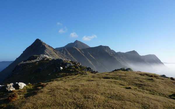
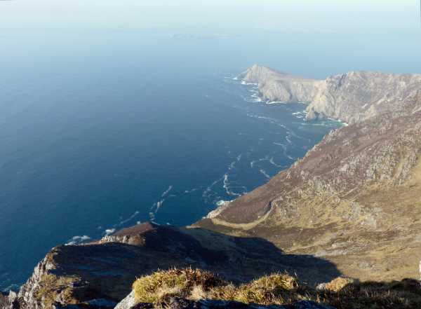
On the cliff path we turned north and paused to devour our sandwiches on the edge of land tilting steeply upwards like the prow of a battle ship relentlessly pounded by the restless Atlantic into vertiginous cliffs, savouring the smell of the briny breeze and the sound of waves booming into hidden zawns far below. Beyond Moyteoge Head with its abandoned coastguard watch-house lay Clare Island floating somewhere between sea and sky as if in a mirage, the distinctive shape of Knockmore just visible in the haze. Meandering on the path that rose and fell steeply above Benmore Cliffs we were finally treated to the sight of Achill Head, a crooked finger of land stretching defiantly out into the Atlantic Ocean for over a mile, ending with the sea stacks Gaoí Saggart and Carrickakin.

At 
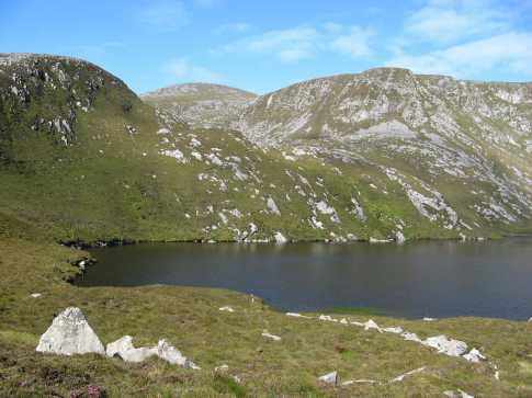
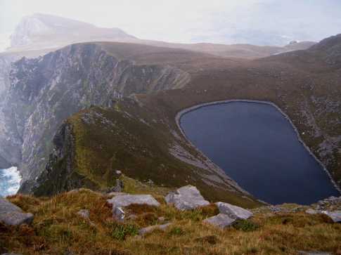
A (F54624 05171) we descended north of two lakes crossing the bog at the valley bottom to climb the steep stone and heather clad eastern slopes of Croaghaun. In the mid-afternoon heat and high humidity this proved to be an ordeal enlivened only by the fascinating geology of Dalradian quartzites and schists formed around 600 million years ago, many rocks sporting amazing patterns left behind by myriad lichens in shades of ochre, beige and burnt sienna. Walking over rocks resembling a decorative pathway studded with quartz pebbles that are 2 billion years old, swept down in an ancient deluge onto a floodplain from a mountain range in the former continent of Laurentia, gently reminds one of the fleetingness of human life when set against the immensity of geological time.

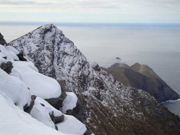
After a punishing ascent we reached Croaghaun SW Top, a pyramidal giant sliced away by glaciers on its seaward side during the last Ice Age. Great care must be exercised on the walk from here to Croaghaun as enormous slabs of sloping rock form terrifying cliffs some 668m above the turbulent ocean, where one slip would spell instant death. From the summit of Croaghaun are magnificent views east towards Saddle Head, Blacksod Bay and Slievemore and south towards Dooega Head. We then descended steep ground heading SSE meeting the road at D (F56446 04628) above Keem Strand, completing our 9km walk in about 5 hours. Linkback: mountainviews.ie/summit/127/comment/4617/
Read Less
Read More

            MountainViews.ie picture about Croaghaun (<em>Cruachán</em>)
Picture: Croaghaun from Lough Acorrymore. The summit can be reached via the hollow behind the lake.
pdtempan on Croaghaun
by pdtempan 28 Aug 2007
We climbed Croaghaun from Dooagh taking the road up to Lough Acorrymore. Skirting the lake to south, we picked up a track which leads into the bowl above it. The track disappeared, but the going was good underfoot and we were able to reach the summit in 2¾ hrs. All approaches to Croaghaun are inevitably steep, but this is one of the easiest routes available with plenty of interest on the way up. We had spectacular views of Keel Bay, Minaun Cliffs and Slievemore on the way up. Further afield, the view took in Croagh Patrick, Mweelrea and many islands, including Clare Island, Inishturk and Inishbofin. The mist foiled us at the summit, though, and we only got glimpses of the cliffs north of Croaghaun. Linkback: mountainviews.ie/summit/127/comment/2806/
Read Less
Read More

            MountainViews.ie picture about Croaghaun (<em>Cruachán</em>)
darrenf on Croaghaun
by darrenf 15 Mar 2010
Took the advice of pdtempan and decided to take on Croughan from the Acorrymore side on the weekend of 5th March 2010. It seemed like such an obvious approach when reviewing the map as all other approches appeared long and steep. We pulled up to the carpark at Lough Acorrymore ( L Acor (F578 058)) on what was a glorious March morning, dare I say possibly near perfect conditions for Croughan. The carpark is located at the very end of the road that is clearly indicated on sheet 30. There is plenty of space for parking at this location and also a number of lay-bys that could accomodate one or two cars at various locations along the road too.

We set off from the carpark and headed around the south side of the lake. As mentioned by pdtempan there are various trails which can be picked up and indeed most seem to head for the bowl over Lough Acorrymore. Instead we decided to head for spot height 474 and approach Croughaun directly from there. The going was extremely good underfoot with spectacular views behind us right across Keel strand, Minuan, and the entire island. As SH 474 is reached the ground levels out and offers some restbite before the ascent of Croughaun in earnest. The climb is steep but short lived, and its not long until the breathtaking sea cliffs and awe inspiring coastline below Croughaun appear, almost out of nothing. One could easily spend hours up here just admiring the beauty in every direction. The one down side I did find with this route was that we missed out on the cliff walk (and no doubt splendid views) from Keem strand carpark and up above the old lifeguard station, but alas all the more reason for a 'next time'.

From Croughaun we walked north along the cliff edge toward SH 574. As I said the conditions on the day could not have been better. Clear skies, sun, absolutely no wind, firm layer of snow and frost underfoot and more importantly no mist. However I would definitely support the comments from fellow MVers with regard to the dangers lurking up here on a misty or windy day. Care should be taken. The views walking along the ridge between Croughaun and SH 574 are reason enough to make the trip (see further photos below). Having come this far I wasnt about to leave without a glimpse of the infamous Bunnafreva Lough. It truly is well nestled behind the cliffs below 574 and hangs precariously close to the sea cliffs. From here we reluctantly headed for home by simply skirting around the cliffs north of Acorrymore and making a knee jerking descent to the shore of Lough Corryntawy. A short hop brought us back to the car. Just under 7km in total, and a trip I will without doubt be making again. Linkback: mountainviews.ie/summit/127/comment/4501/
Read Less
Read More

            MountainViews.ie picture about Croaghaun (<em>Cruachán</em>)
Picture: Lough Bunnafreva West
gerrym on Croaghaun
by gerrym 28 Aug 2007
I reached the summit from the beautiful carpark at Keem, climbing to the jagged cliffs stretching to Achill Head before dropping steeply and ascending even more steeply to the SW top (see for more detail). From the SW top of Croaghaun it is a short drop and curving reascent above the steep cliffs below to reach the summit cairn. I had no view in the mist, but peering down over the cliff edge I had fleeting glimpses of water impossibly far below. I dropped down following the cliff edge, a gust of wind lifted me of my feet and made me run about 30 ft downhill, did I s**t bricks - yes! Views out to Saddle Head appeared as i dropped. There are a couple of gullies which need to be aware of if staying close to the cliff edge as are separated from the main ground. The undoubted highlight of the walk is when Lough Bunnafreva West appears, an impossibly suspended corrielough with plunging cliffs eating ever closer. I got a glimpse of Lough Nakeeroge even further down near sea level. From here i headed S and dropped down steeply beside Lough Acorrymore towards Lough Corryntawy, where a large group of young people where camped. There is an impressive double corrie here, the higher having no lough. Follow road servicing the loughback to the main road and from there the road to Keem (4 km). It is when walking along this raod that the unhindered drops down into the ocean are very apparent, made me more thoughtful on the pull up the hill out of Keem in the car.
Fantastic days walking along with Croaghaun, even with the wind - has just about everything - ocean, loughs, streams, cliffs, stunning views and not many other people about on the day i climbed. Having returned to visit Slieve League recently I am in two minds as to which is the more impressive - it is close but i think that here just loses out by a proverbial whisker! Linkback: mountainviews.ie/summit/127/comment/2186/
Read Less
Read More

cathalferris on Croaghaun
by cathalferris 5 Jan 2009
On Friday Jan 2nd a group of us went to Croaghan from the bog road between Dooagh and the Deserted Village.
We started out at about 11am, fairly well kitted out for the near-freezing almost clear conditions and the strong easterly wind.
It's a nice trek along the bog around the old lifeguard station. The bog was (mostly) frozen which made the trek so much more enjoyable!
We passed along the saddle above Annagh beach and approached the summit ridge above Lough Corrymore from the northeast, threading the line between the seacliffs and the corrie cliffs. The views are pretty good on the way up, seeing small lakes in the peat on hte ridgelines, and the ice crusting up all of the heather and grass around us.
From the start the terrain is mostly standard hilly bog, fairly dry and crispy in the cold though. After crossing the head of the stream that drains the eastern slopes at about the 380m contour the terrain changed to a drier more rocky ground underfoot which made the progress much easier. Of the 9 that started out the trek, only 3 of us considered from here that we had the will and the equipment at this stage to enter into the clouds that were shrouding the summit. The rest decided to turn and make their way back in case the conditions worsened. The easterly gales were a bit of an issue to be honest, as we were well aware of the shape of the cliffs just over the ridgeline to our west as we progressed along the ridge and climbed up the steep final climb. As we were crawling up to the cairn, we turned to watch the clouds roar up the hanging valley and whistle past our heads while the cairn area was actually in relative calm. The descent was nice and quick retracing our steps back towards Crumpaun, reaching our start point at about 16.30.
It's a really nice hike though we were lucky to be there after a few days of sub-zero conditions that had nicely frozen the surface of the bog. Linkback: mountainviews.ie/summit/127/comment/3509/
Read Less
Read More
EDIT Point of Interest
text
Videos


Users Online

Guests online: 329
Recent Contributions
x
Conditions and Info
Use of MountainViews is governed by conditions and a privacy policy.
Read general information about the site.
Opinions in material here are not necessarily endorsed by MountainViews.
Hillwalking is a risk sport. Information in comments, walks, shared GPS tracks or about starting places may not be accurate for example as regards safety or access permission. You are responsible for your safety and your permission to walk.
See the credits and list definitions.

OSi logo
OSNI/LPS logo
Open Street Map
(Various variations used.)
British summit data courtesy:
Database of British & Irish Hills