This website uses cookies, which are small text files that the website puts on your device to facilitate operation. Cookies help us provide a better service to you. They are used to track general user traffic information and to help the website function properly.
Feature count in area: 9, by county: Down: 5, Antrim: 4,
OSI/LPS Maps: 15, 20, 21
Highest Place: Divis 478m
Starting Places (2) in area Belfast Hills: Ballyherly Lough West, Castlemahon Mountain South East
Summits & other features in area Belfast Hills: E: Belfast Hills East: Cairngaver 217m, Ouley Hill 186m, Scrabo Hill 160m N: Belfast Hills North: Carnmoney Hill 231.1m, Cave Hill 368m, Divis 478m, Slievetrue 312m SE: Strangford & Portaferry: Ballywhite Hill 101m, Castlemahon Mountain 128m
Note: this list of places may include island features such as summits, but not
islands as such.
Carnmoney Hill, 231.1mHill Cnoc Charn Monaidh A name in Irish,
Place Rating ..
, Antrim County in Ulster province, in Binnion Lists, Carnmoney Hill is the 1335th highest place in Ireland. Carnmoney Hill is the second most northerly summit in the Belfast Hills area.
Grid Reference J33225 83054,
OS 1:50k mapsheet 15 Place visited by: 42members, recently by: Paddym99, garybuz, Oscar-mckinney, Jai-mckinney, ElaineM76, seamaspeineas, Combat_Monkey, eflanaga, Matrim, Kirsty, dregish, Vfslb1904, Carolyn105, Andy1287, trostanite
I visited this place: NO (You need to be a logged-in member for this.)
Longitude: -5.935395, Latitude: 54.677946, Easting: 333225, Northing: 383054,
Prominence: 109m, Isolation: 3.5km, Has trig pillar
ITM: 733145 883047 Bedrock type: Olivine basalt lava, (Lower Basalt Formation) Notes on name: The first element in the name Carnmoney is clearly Ir. carn, ‘cairn’, but the second element is less certain. Patrick McKay interprets it as monadh, ‘mountain’, which fits the landscape. However, whilst monadh is common in Scottish place-names, it is rare in Ireland. Other possibilities include muine, ‘thicket’, and mónadh, ‘bog’. The form Cnoc Charn Monaidh is offered here as a reconstruction.
Short or GPS IDs, 6 char: Crn231, 10 char: CrnmnyHil Linkback: https://mountainviews.ie/summit/1246/
Gallery for Carnmoney Hill (Cnoc Charn Monaidh) and surrounds
No summary yet for this place
.
Member Comments for
Carnmoney Hill (Cnoc Charn Monaidh)
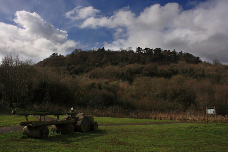
Picture: From near the starting and finishing point, summit hidden.
Pleasant Walk, Spoiled A Little By Heavy Rain
by Aidy
26 Mar 2014
It was a beautiful day in Belfast where I had travelled for work, and as I didn't have boots or any other gear I thought I would have a look a this small hill, having recently seen it on one of gerrym's excellent videos. I started from Knockenagh Avenue and simply followed the blue waymarked trail through the pleasant woodland, until I emerged on to open fields. There is a good guide to the walk on Walkni.com, with downloadable maps and leaflets, but it does give the impression that the hilltop walk will take you over the summit, which is not the case. When you leave the trees on higher ground, you need to leave the trail, and cross the fields to the now clearly visible summit. Its a nice walk through the woods, and the views are good, although those from nearby Cave Hill are probably better if you only have time for one or the other. Unfortunately for me, as I got near the top, clouds drew in and it began to rain heavily, so I couldn't even take the camera out until I reached the foot of the hill again. Linkback: mountainviews.ie/summit/1246/comment/15944/
Read Less
Read More
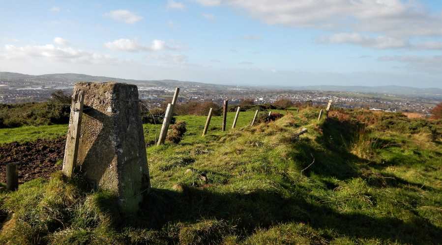
Picture: View west from Carnmoney Hill
No electric fences please
by eamonoc
30 Oct 2017
Went to Knockenagh Avenue to climb Carnmoney Hill, followed blue route uphill to open fields as mentioned by Aidy, was approx 400m from top which was clearly in view but many newly constructed barbed wire fences plus fairly substantial electric fences barred the way, went back dowwnhill drove around to Carmoney village an on towards Ballyduff Industrial estate. Drove up a very narrow road towards a private house at A (J33374 83752). Parking for one car here and used Mast access road to get close to top, a small gap in a fence had to be climbed and a walk across a small boggy dip to gain the top where there is a Trig point. Good views towards Cave Hill and out over Belfast Lough from top. Linkback: mountainviews.ie/summit/1246/comment/19775/
Read Less
Read More
Good way to spend an evening in Belfast
by Trigpoint100
30 Aug 2018
Like Aidy I was in Belfast for work and ill equipped for any serious jaunt. However, I did find a simple route to the top of Carnmoney, which offers panoramic views of Belfast and surrounds. As eamonoc, start from the Ballyduff side. The lane from A eomonoc used is now gated. But a few yards west of the start of this lane on Ballyduff Road is a cinder track, which leads without obstruction or bog to the summit. Out and back this way would be a very quick jaunt. In my case, being on the bus, I carried on over the summit and came down into Glengormley via Glebe Road (head SW off the summit and you will hit a farm track). Very enjoyable. Linkback: mountainviews.ie/summit/1246/comment/20043/
Use of MountainViews is governed by conditions and a privacy policy.
Read general information about the site. Opinions in material here are not necessarily endorsed by MountainViews.
Hillwalking is a risk sport. Information in comments, walks, shared GPS tracks or about starting places may
not be accurate for example as regards safety or access permission. You are responsible for your safety and your permission to walk.
See the credits and list definitions.


 Our Facebook page.