This website uses cookies, which are small text files that the website puts on your device to facilitate operation. Cookies help us provide a better service to you. They are used to track general user traffic information and to help the website function properly.
Feature count in area: 27, by county: Mayo: 15, Galway: 15, of which 3 are in both Galway and Mayo,
OSI/LPS Maps: 37, 38, CBE, EW-CON, MSW
Highest Place: Maumtrasna 682m
Starting Places (54) in area Partry & Joyce: Aasleagh Waterfall CP, An Móinín Mór, Ballydoo Lough, Barrevagh Bridge, Bealanabrack River Tributary, Black Rock, Bohaun, Bracklagh, Buckaun, Bunduvowen, Cammanagh, Carraig Bar, Carrowrevagh Lough, Clonbur, Cummer, Derrassa, Derrinkee Wood, Doon Rock, Failmore River, Finny Church, Fooey River Road, Glendavock, Glenmask, Glennacally Bridge, Glensaulmore Trailhead, Glentraigue, Gowlaunlee Lake, Keelkill North, Killeennimat Burial Ground, Knockaunnabausty (Cnocán na bPáistí), Knocknafaughy SW, L Mamwee, Lecarrow, Leenane, Leenane Hotel, unuseableLeenane R336, Lough Nambrackkeagh, Maum Bridge Road Lower, Maum Bridge Road Mid, Maum Bridge Road Upper, Mount Gable CP, Otter Pool, Owenbrin Bridge, Owenbrin Tributary, Owenduff River, Red Island, RIC Barracks Ruin, Rinavore East, Rinavore SW, Shanafaraghhaun Cross, Sheeffry Pass, Tawnyard Lough, Teevinish West, The Larches Pub
Summits & other features in area Partry & Joyce: Cen: Finny: Glenbeg East 372m Cen: Knocknafaughy: Knocknafaughy 254m, Rinavore 426m Cen: Maumtrasna: Barnahowna 516m, Buckaun East 495m, Glennagleragh Mtn 617m, Knocklaur 518m, Maumtrasna 682m, Maumtrasna North-East Top 572m, Tullymorehill 279m N: Ballintober Hills: Bohaun 393m, Corveagh 233m, Croaghrimkarra 271m, Keelkil 239m SE: Cornamona: Mount Gable 417.8m, Bohaun 424m, Knocknagussy 456m SW: Bunnacunneen: Ben Beg 560m, Bunnacunneen 575m, Bunnacunneen South Top 539m, Bunnacunneen SE Top 479m, Lugnabrick SW Top 494m, Lugnabrick NE Top 494m W: Devilsmother: Devilsmother 645m, Devilsmother South Top 509m, Devilsmother North Top 595m, Devilsmother Far North Top 601m
Note: this list of places may include island features such as summits, but not
islands as such.
Tullymorehill, 279mHill
Place Rating ..
, Mayo County in Connacht province, in no lists, Tullymorehill is the 1211th highest place in Ireland.
Grid Reference M03900 64400,
OS 1:50k mapsheet 38 Place visited by: 7members, recently by: Lauranna, eamonoc, markmjcampion, Fergalh, Garmin, paddyhillsbagger, Jamessheerin
I visited this place: NO (You need to be a logged-in member for this.)
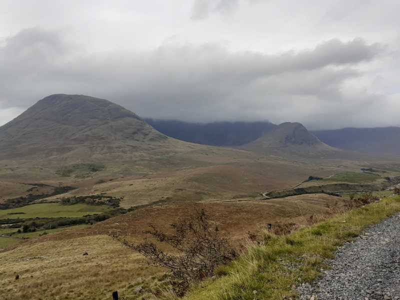
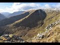
Picture: The view over to Maumtrasna massif from where I parked.
Part of a fine circuit
by markmjcampion
28 Oct 2020
I parked in the place mentioned by Paddyhillsbagger (room only for one well-tucked-in car) but thereafter our plans differed as I had decided to combine it with a a few other higher hills to make a day out of it. I included Barnahowna and Maumtrasna NE top as part of a 5.5 hour loop. The ascent was easy and dry...I aimed for the saddle to the west and then headed up and down to the summit before continuing on my circuit. Fine views of Buchaun and Lough Mask from the summit cairn. Linkback: mountainviews.ie/summit/1174/comment/21103/
Read Less
Read More
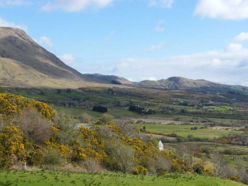
Picture: It's the little one on the right!
Small hill. Big views.
by paddyhillsbagger
17 Apr 2016
The joy of small hill bagging is being able to fit them in before or after doing something else! With a few hours to spare I bagged lovely Tullymorehill accompanied by singing Skylarks and bleating sheep. I left the car at Gl'saul Tr (M04117 63978), followed a dirt track NW a few hundred metres then headed up the short steep and slippery slope to the top. Magnificent views over Lough Mask and the nearby Maumtransa range. There is a small cairn at the top. Linkback: mountainviews.ie/summit/1174/comment/18496/
Use of MountainViews is governed by conditions and a privacy policy.
Read general information about the site. Opinions in material here are not necessarily endorsed by MountainViews.
Hillwalking is a risk sport. Information in comments, walks, shared GPS tracks or about starting places may
not be accurate for example as regards safety or access permission. You are responsible for your safety and your permission to walk.
See the credits and list definitions.


 Our Facebook page.