Members and Supporters, the MountainViews Committee requests your help to meet the costs of the website and of other activities such as insured events or publications.
Feature count in area: 45, all in Donegal,
OSI/LPS Maps: 11, 6
Highest Place: Croaghgorm 674m
Starting Places (22) in area Bluestack Mountains: An Leathchruach, Barnsmore Gap, Bensons Hill, Caldragh CP, Clogher South peak, Cruach Mhín an Neanta, Doobin, Eanybeg Water Bridge, Edergole Farm, Gaugin Mountain, Glennacree CP, Hillhead, Lough Finn West, Lough Magrath Beg NE, Lough Muck North, Meenaguse Lough, Sand Lough Forest Picnic Area, Scoil Náisúnta an Choimín, Sheskinlubanagh, Sruell Gap Farm, Sruell River Road, St Columbkilles Well and Altar
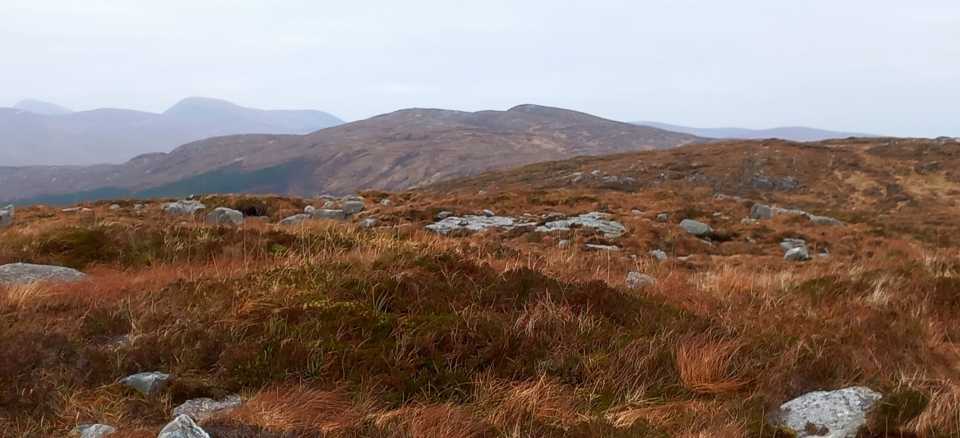
Summits & other features in area Bluestack Mountains: Cen: Reelan Hills: Altnapaste 364m, Gaugin Mountain 565m, Lacroagh 403m, Boultypatrick 429m, Croveenananta 476m, Croaghubbrid 416m, Croaghugagh 410m N: Fintown Hills: Aghla Mountain South Top 589m, Aghla Mountain 593m, Scraigs 426m, Croaghleheen 385m NW: Glenties: Cloghercor South 301m, Derkbeg Hill 332m, Drumnalough Hill 282m S: Belshade: Croaghgorm 674m, Croaghgorm South-West Top 597m, Croaghgorm East Top 594m, Ardnageer 642m, Ardnageer SW Top 626m, Banagher Hill 392m, Croaghbane 641m, Croaghgorm Far South-West Top 561m, Cronamuck 444m, Croaghbarnes 498.8m, Glascarns Hill 578.3m, Meenanea 435m SE: Barnesmore: Brown's Hill 496.4m, Cloghervaddy 402m, Croaghagranagh 440m, Croaghanirwore 546.1m, Croaghbrack 401m, Croaghconnellagh 523m, Croaghnageer 569.1m, Croaghnageer East Top 543.5m, Croaghnageer North-East Top 521m, Croaghonagh 451m SW: Eany Beg Hills: Binbane 453m, Binbane NE Top 439m, Lavagh Beg 650m, Lavagh More 671m, Binnasruell 505m, Carnaween 521m, Cloghmeen Hill 429m, Silver Hill 600m, Cullaghacro 476m
Note: this list of places may include island features such as summits, but not
islands as such.
Cloghercor South, 301mHill
Place Rating ..
, Donegal County in Ulster province, in Binnion Lists, Cloghercor South is the 1157th highest place in Ireland.
Grid Reference B85500 00100,
OS 1:50k mapsheet 11 Place visited by: 6members, recently by: eamonoc, melohara, Aidy, chalky, Fergalh, Garmin
I visited this place: NO (You need to be a logged-in member for this.)
Picture: The forest ride to summit of Cloghercore South
Nice loop walk
by Fergalh
9 Jan 2023
Park at A (G84119 99299), proceed up Gaffaretcore hill. At top B (G84858 99291) (which is 292 Metres) look across at Gafarettermoyle and proceed down along forest edge before climbing. Both Gafarretermoyle SW top and Gafarettermoyle NW Top are both 301 metres. On way back drop down off Gafarettermoyle SW Top to forest ride and follow rough deer track to edge of forest at approx C (G84413 99711) a short journey back to car follows.This hill is also known as Cloghercore south Linkback: mountainviews.ie/summit/1140/comment/17698/
Read Less
Read More
Picture: View towards Croaghleheen
Worth a visit if passing
by eamonoc
29 Jan 2023
Direct route up and down from R250, plenty of parking at D (G86210 99124), cross road to farm gate and onto open hillside for boggy trek to summit Linkback: mountainviews.ie/summit/1140/comment/23821/
Use of MountainViews is governed by conditions and a privacy policy.
Read general information about the site. Opinions in material here are not necessarily endorsed by MountainViews.
Hillwalking is a risk sport. Information in comments, walks, shared GPS tracks or about starting places may
not be accurate for example as regards safety or access permission. You are responsible for your safety and your permission to walk.
See the credits and list definitions.


 Our Facebook page.