This website uses cookies, which are small text files that the website puts on your device to facilitate operation. Cookies help us provide a better service to you. They are used to track general user traffic information and to help the website function properly.
Short or GPS IDs, 6 char: Ailwe, 10 char: Aillwee Linkback: https://mountainviews.ie/summit/1134/
Gallery for Aillwee and surrounds
Summary
for Aillwee :
great views with little challenge
Summary created by curus_lulus
2014-04-26 02:00:08
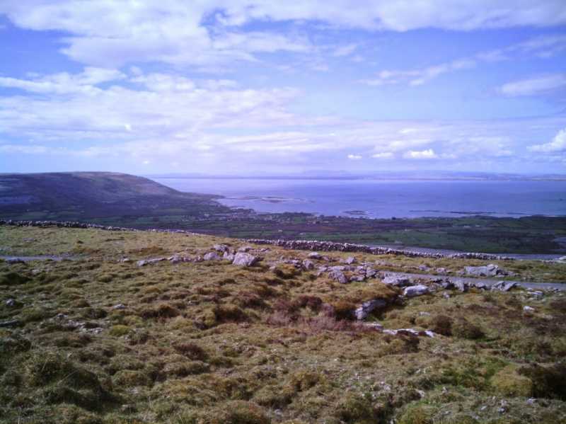
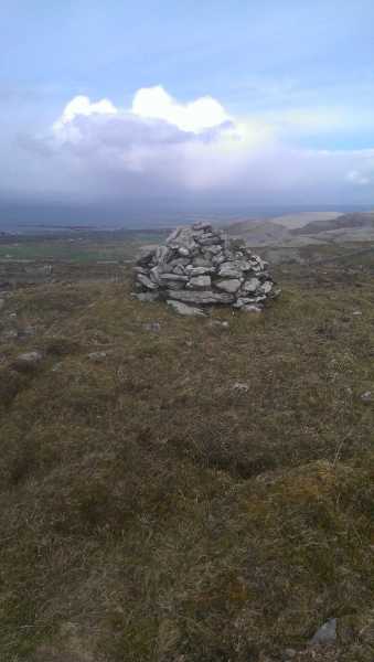
Picture: Black Head and Galway bay from Aillwee Hill
This hill is not much of a challenge but offers spectacular views of the Northern Burren, from Black Head to Abbey Hill and the Galway Bay in between. The top is near the farm road and marked by a small limestone cairn.
There are two access routes, from SW at 10km roundtrip and only 150 elevation gain, from NE at ca 6km roundtrip and 270m elevation gain.
I haven't tried the NE approach so far. From both sides the access is through a private farm but there is apparently a public right of way and the farmer is friendly as long as you leave all gates as found and do not disturb cattle.
Approaching from SW, it is a long walk with little elevation change, you will see several doolin depressions and some neolithic tombs, no markers no tourists.. just cattle every now and then. The views opening to the north come as a shock when you approach the rim. If approaching from NE, you have the views all the time, just gaining prominence.
SW parking spot is at N 53.06647 W 9.15035
This is near the Glenosheen Collar find site. A memorial to Paddy Nolan who found the precious collar is at the right farm gate. You need to take the left farm gate to access the summit, the right one is cul de sac.
NE parking spot is at N 53.1031 W 9.0868
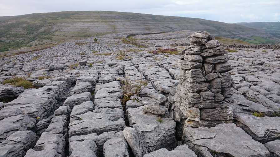
In 2014 I took a route starting on the N67 coast road several kms north of Aillwee. This took me over two smaller rugged hills named Kiloghil and Moneen before reaching Aillwee. This approach showed the best of the Burren landscape –areas of limestone crisscrossed with clints (blocks or broad areas of limestone) and grykes (fissures between the blocks), rugged, thorny bushes and colourful flowers. There are also lots of high limestone steps to negotiate which involved pulling myself up on various occasions. The tangled thorny growth that protrudes from between the rock also made navigation tricky in places. After a careful descent of the limestone steps to the south of Moneen I reached the track referred to by Sandman in his comment. The track leads up past the flat summit of Aillwee. It is a disappointing summit to reach after the excitement and challenge of the approach journey. The broad flattish summit of Aillwee is grassy, and is crisscrossed by tracks. I used these to find my down to reach a point on the R480 to the SW of Aillwee to complete a 12 km walk.
Aillwee is home to the famous Aillwee cave. It was discovered by a local man, Jack McGann when his dog chased a rabbit down a hole. Curiously, Jack did not tell anyone about the cave for 30 years. In 1973 he told some cavers about it. The rest (commercial development) is history. Because of streams carving out tunnels in the soft limestone, the Burren area is home to many cave systems that are still being discovered today. Doolin Cave has opened to the public in recent years and features the largest Stalactite in the northern hemisphere, at 23 feet. Their blurb poetically puts it that ‘. Visitors can hardly believe that it was formed from a single drop of water over thousands of years’. Having seen it in person, after a gruelling 8 storey climb down a circular stairway followed by a series of tunnels and caves, I can tell you that Doolin Cave is impressive. The Burren caves were back in the news recently when a father and son were rescued after spending 28 hours lost in the extensive Pollnagollum cave complex on Slieve Elva (Another MountainViews listed summit)
I read that in previous times local farmers had to become experts in managing broken legs in cattle due to the infinite amount of fissures/grykes in the limestone that cattle could stumble into. One account was about a local man on Aillwee who had a special recipe of swaddling, tar and herbs to wrap the broken legs in, which promoted recovery. This same man also spoke about, as a boy, how he explored all the old farmsteads of Aillwee that had been abandoned in the Famine as their owners died or emigrated. He talked of finding everything from whiskey to money in the old stone walls. Many decades later, as I strolled up the slopes of Aillwee, I had to watch my own step as I navigated across the same fissures in the rock, and wondered if any of the ruins I saw were where he had found his treasure as a boy. Linkback: mountainviews.ie/summit/1134/comment/18287/
Read Less
Read More
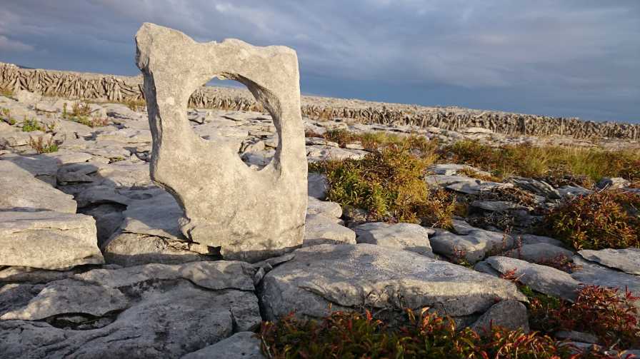
Picture: The power of erosion
Art or practicality?
by wicklore
4 Sep 2015
When rainwater slowly erodes the flat limestone pavement of the Burren, it sometimes forms shallow bowl in the rock. Sometimes the shallow bowls erode further and penetrate the layer of limestone rock entirely. Sometimes someone (landowner presumably?) picks up one of these layers of rock with a hole eroded entirely through and stands it upright in a gryke (fissure) in the limestone pavement. More often than not the upright rocks placed in the grykes are solid and are dotted around the landscape. For what purpose? I suggest it is an attempt to keep livestock from stepping into these fissures and breaking a leg. My picture shows one curious example I spotted on the northern slope of Aillwee Hill. Linkback: mountainviews.ie/summit/1134/comment/18288/
Read Less
Read More
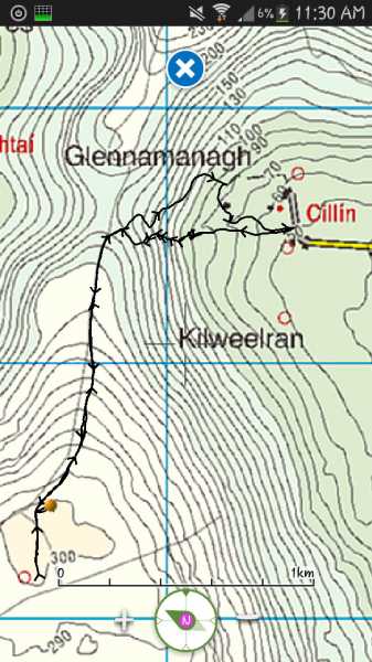
Picture: Ailwee route
Barred Access
by Jamessheerin
22 Sep 2016
Whether the aforementioned road ("upgraded under Clar program") is a right of way or not I cannot say but be advised... it is no longer usable. A five foot high gate with lock and chain now bars all passage. I have uploaded a screenshot of my route up and down. Parked at A (M26489 06523). Continued up track and headed directly for the col on rough ground. I would not advise anyone to take the same route! It only looks like a short distance, but "rough ground" is a mild description! On the way down we stuck to the track (which goes all the way to summit and beyond) but to avoid the high gate went into the fields (through a gate at B (M26234 06694)) on the right close to the house. Please see photo. Another two fields (and gates) will bring you through to start point. This area is intensively farmed and there is livestock present and I entered it reluctantly. Watch out for the electrified fences. It may not be suitable to use at all times? The track to the summit seems to run all the way through to the far side of the hill and may be a better way in if the houseowner there insists on barring access? I will investigate the access from the west at a later date... Linkback: mountainviews.ie/summit/1134/comment/18638/
Read Less
Read More
Picture: Summit Area.
Rural Development
by sandman
13 Apr 2015
Accessing the hill from the NE via a road which was upgraded under the "Clar Programme" for rural development. I drove thru old type gates to a farm house which at the time was for sale and as no one was present continued on and parked at C (M25991 06609) adjacent to a locked gate. This road is a public right of way so access is not an issue(but it is always nice to ask) and as a matter of note if the gate is unlocked you can drive to the summit area on a tarred surface.
On a nice day the views are rewarding and you can visit the " Aillwee Cave" as part of your walk if time permits. Linkback: mountainviews.ie/summit/1134/comment/17926/
Read Less
Read More
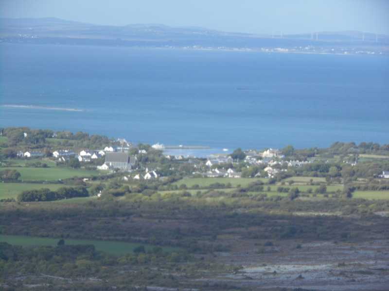
Picture: Ballyvaughan from Ailwee
Ailwee & Moneen
by TommyV
25 Oct 2018
Leaving Ballyvaughan on the N67 towards Kinvarra, there is a right turn at D (M23589 08060) that will bring you to a wood loop walk which will bring you to the car park for the Ailwee Caves at E (M22982 05170). At the top of the car park there is an obvious path through the bushes leading onto the open hill. It's a straight forward walk to the summit of the hill, although attention needs to be paid to where you walk as the surface is covered in heather grass and some real ankle breaker holes lie hidden. You will see a road running along the summit next to the cairn, it's possible to follow this North towards Moneen Mountain. At the col leave the road at F (M25814 06534) and follow the stone wall to the summit. From here we descended to a farm near a graveyard at G (M25401 08350) and had a kilometere to walk on a busy N67 on a June Bank Holiday weekend. A better option might be to descend to the Green Acres holiday cottages at H (M24985 07601) and follow this road back to Ballyvaughan. Linkback: mountainviews.ie/summit/1134/comment/20088/
Use of MountainViews is governed by conditions and a privacy policy.
Read general information about the site. Opinions in material here are not necessarily endorsed by MountainViews.
Hillwalking is a risk sport. Information in comments, walks, shared GPS tracks or about starting places may
not be accurate for example as regards safety or access permission. You are responsible for your safety and your permission to walk.
See the credits and list definitions.


 Add a Place Comment for Aillwee


 Our Facebook page.