This website uses cookies, which are small text files that the website puts on your device to facilitate operation. Cookies help us provide a better service to you. They are used to track general user traffic information and to help the website function properly.
Feature count in area: 27, all in Galway,
OSI/LPS Maps: 37, 38, 44, 45, EW-CON
Highest Place: Binn idir an dá Log 702m
Starting Places (45) in area Maamturks: An Móinín Mór, Bealanabrack, Bealanabrack River Tributary, Bundorragha Estuary Cross, Cannaclossaun, Carraig Bar, Connemara Mountain Hostel, Delphi Resort, Dernasliggaun, Drehidanookera Bridge, Failmore River, Fee Lough SW, Glashmore Bridge, Glencraff Road End, Gleninagh River, Gowlaunlee Lake, Illaunroe South, Killary Boat Tour Pier W, Knocknafaughy SW, Kylemore River, L Mamwee, Leenane, Leenane Hotel, unuseableLeenane R336, Lehanagh Lough N, Lehanagh Lough SE, Lough Fee East, Lough Nacarrigeen S, Lough Shindilla S, Maum Bridge Road Lower, Maum Bridge Road Mid, Maum Bridge Road Upper, Maumwee Lough, N59 Junction, Nambrackkeagh Lough, Oorid Lough, Owenwee River, Pas Mám Éan CP, Rinavore East, Rinavore SW, Shanvally, Tawnabeg Lough North, Tooreennacoona River, Western Way Cnoc na hUilleann, Western Way Inagh Cottages
Summits & other features in area Maamturks: N: Leenaun: Maumturkmore 488m, Búcán 550m, Leenaun Hill 618m, Leenaun Hill Far North-West Top 556m, Lettershanbally 324m, Meall Cheo 578m, Taobh Dubh 422m N: Maumturks N Cen: Barrlugrevagh 558m, Letterbreckaun 667m, Letterbreckaun NE Top 603m, Knocknahillion 607m, Knocknahillion North Top 541m, Cúlóg 435m S: Maumturks S Cen: Binn Chaonaigh 633.5m, Binn idir an dá Log 702m, Binn idir an dá Log SE Top 659.3m, Binn Mhairg 612.4m, Knocknagur 310m S: Maumturks South: Binn Mhór 660.6m, Binn Mhór NE Top 641.2m, Binn Mhor West Top 595.8m, Binn Mhor East Top 631.3m, Lissoughter 401m, Corcogemore 610.1m, Mullach Glas NE Top 432m, Lackavrea 396m, Mullach Glas 621.3m
Note: this list of places may include island features such as summits, but not
islands as such.
Binn idir an dá Log, 702.0mMountain
Place Rating ..
(Ir. Binn idir an dá Log [TR], 'peak between the two hollows'), Mulnahogue, Galway County in Connacht province, in Arderin, Vandeleur-Lynam, Irish Best Hundred, Irish Highest Hundred Lists, Binn idir an dá Log is the highest mountain in the Maamturks area and the 111th highest in Ireland. Binn idir an dá Log is the third highest point in county Galway.
Grid Reference L88816 52823,
OS 1:50k mapsheet 37 Place visited by: 436members, recently by: rosduke, bowler, RonanS, Djouce, Aidan_Ennis, discovering_dann, bandre, DarrenY, RosieMc, Glengirl, farmerjoe1, TipsyDempy, rhw, andalucia, BarnabyNutt
I visited this place: NO (You need to be a logged-in member for this.)
Longitude: -9.676782, Latitude: 53.513814, Easting: 88817, Northing: 252824,
Prominence: 629m, Isolation: 0.6km ITM: 488791 752845 Bedrock type: Pale quartzites, grits, graphitic top, (Bennabeola Quartzite Formation) Notes on name: Walks: for a route along the ridge taking in Binn Chaonaigh and Binn idir an dá Log , see Kevin Corcoran, West of Ireland Walks, 81-92.
Short or GPS IDs, 6 char: Bnidrn, 10 char: BnidrndáLg Linkback: https://mountainviews.ie/summit/108/
Gallery for Binn idir an dá Log and surrounds
Summary
for Binn idir an dá Log :
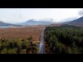
Impressive rocky top on fine ridge with good views.
Summary created by markmjcampion, simon3, wicklore
11 Sep, 2023
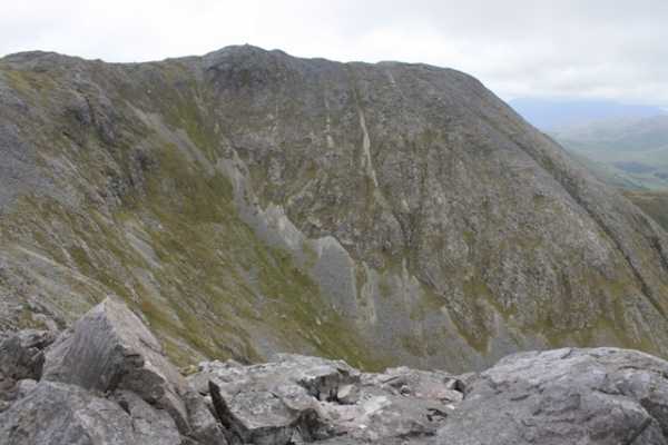
Picture: Binn idir an dá Log
Binn Idir an Dà Log (BIDL) is the highest Maamturk and is a v impressive mountain. It has corries to the E and S, with steep ridges leading to the summit from the N and S. The upper few hundred metres is pure quartzite so good footwear is needed on the shattered stone and sandy trails carved out by countless boots. Care is needed on any walk in the Maamturks as there are few escape options in bad weather or if you tire. Amazing views of the 12 Bens and the S Mayo hills.
S. From the CP at MámÉan (L89193 49491) take the good track up to the large col known as Maumeen. Turn left to climb 400m up to Binn Chaonaigh over initial steep grassy slopes and then shattered rock. From BC there is a ridge leading first to BIDL SE Top, and then on to BIDL itself. This route involves about 700m ascent total and 5 kms distance with some sections are steep. Allow 2hrs+
From the same CP, you can walk a couple of km up the road to approx. L Lehan N (L87338 52005) and from here head gently up across open country, eventually over steepening terrain to reach the Maumahoge col at A (L87778 53720). Head N around the lake and follow an obvious track 1.5k SE to the summit. 2hrs+
N. Park at G'laun L (L87866 55710) and follow the obvious track S to B (L87941 54044). Climb up steep grassy slopes to Maumahoge and head for the summit as above. 2hrs
BIDL is also summited as part of the Maamturks challenge which is a 25k walk from the E side or Corcóg to Leenaun village.
Notable tracks include track/3252, track/1863 and track/4090.
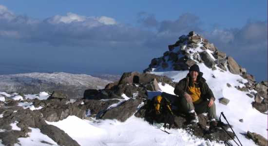
Picture: Looking down to Mam Ochoige from B. Idir an Da Log
CaptainVertigo on Binn idir an dá Log
by CaptainVertigo
18 Sep 2005
INTRODUCTION:During childhood trips to Renvyle in the 1960s I observed the Maamturks from the floor of the Inagh valley. They appeared like a row of elite sentries: austere, uniform, forbidding and insurmountable. A linear cascade of rock. I still felt somewhat daunted by them in August 2005, and wondered just how steep they might prove to be. When I stood at Mam Ochoige, the saddle between Cnoc na hUilleann and Binn Idir an Da Log, I was overwhelmed with a sense of deja vu, because, of course, my Jes Boy comrades and I had been there before during our teenage years:there, on the western side of the Turks was the strange green mossy looking world where, so it seemed, the sun never quite shone. PREPARATION: A "must see" site is our own Simon Stewart's magnificent study at http://www.simonstewart.ie/Turks/turk.htm ; also,Harveys Connemara 1:30,000; OS 37;Dillon -Connemara; Joss Lynam -Best Irish Walks; printout of all contributions here re Maamturks;Google Earth flyovers.MY ROUTE:I'll let you figure out where to park yourself. After that its a gradual walk along streams as you aim for Mam Ochoige (C (L877 537)) until you reach the steep grassy slope from the valley floor to the "Mam" itself. As you turn and face Binn Idir an Da Log you will see the mountain above the lake as shown in SILVER'S excellent photo in his April 04 contribution. I ascended by the route on the left. The rise from the lake area is steep and rocky and requires concentration. As the ground flattens out towards the summit plateau tremendous views open in all directions. This mountain, the highest of the Turks, is king of a thrilling landscape. My photo (below) shows the scene from the shoulder of BIaDLog looking back across Mam Ochoige towards cnoc na HUillean. Linkback: mountainviews.ie/summit/108/comment/1929/
Read Less
Read More
Picture: Sure where would you be ... ?
aburden on Binn idir an dá Log
by aburden
8 Feb 2009
A grand day out - A 12Km loop that took 5 hrs. Maumeen to L. Mham Ochoige via Binn idir an Da Log. Following suggested route west to 450m before contouring around to lake; quite hard going giving the ice/snow but still doable at a slow pace. Found the slippy decent to valley floor frustrating and ended up sitting a lot ! Linkback: mountainviews.ie/summit/108/comment/3568/
Read Less
Read More
csd on Binn idir an dá Log
by csd
31 Mar 2003
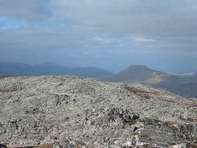
For the route down from Binn idir an Dá Log to Mam Ochoige, see Simon's excellent guide at http://www.simonstewart.ie/Turks/mt2.htm. You need to head for the northern cairn (just visible in the centre of the picture, taken from the main summit) and then turn west until you're down to the 410 metre level, before turning north again to arrive just west of the lake. Linkback: mountainviews.ie/summit/108/comment/408/
Read Less
Read More
Derryvoreada ascent and descent.
by markwallace
30 Dec 2013
The popular descent from Binn Idir is to Mam Ochoige, and is very tricky, as any guide book or commenter here tells you. On a recent trip to Binn Idir I took the direct route off the mountain down to Derryvoreada, heading just west of south from the summit and aiming roughly for the school that sits in isolation in the valley at D (L881 511). This route wasn't recommended in any guide books I had consulted, but looked doable, and was. Later, I made the ascent from the same spot, parking across the road from the school. It's not a good spot for parking, and I'd recommend using one of the other laybys along the road. But the ascent from here is straightforward: Binn Idir is on the right as you look up from ths site, Binn Caoinaigh on the left. Ascent to Binn Idir is direct and steep with some false summits, and some lightish scrambling required, but with no major obstacles or navigational difficulties (on a clear day). It's also more sheltered from prevailing wind and rain than the Mam Ochoige route, or has been on all days I've been in the area.
For those taking the classic route from Mamean to Binn Caoinaigh to Binn Idir the descent from the latter to Derryvoreada leaves a shorter road walk back to the carpark at Mamean and also avoids the long trudge across bog that the Mam Ochoige descent requires. Linkback: mountainviews.ie/summit/108/comment/15245/
Read Less
Read More
fkaatje on Binn Idir an Dá Log
by fkaatje
15 Mar 2021
Climbed this mountain from Maumeen on a bright and sunny St. Patrick's day. Very much enjoyed the spectacular views. And very sorry I could not take pictures (lend out the camera) In spite of all warnings I was still surprised by the steep and tricky descent to Mám Ochóige. Also the descent from the col to the west involves a nasty steep grass slope. Best to opt for the direct line down here and to keep the stream on your right hand. I think this climb would be a bit easier ascending then descending. This should give you a better view of the layout of the mountain which should simplify route finding a bit. Also there should be less risk of slipping on the treacherous steep grass slopes. You can view and download my GPS trail on http://www.wikiloc.com/wikiloc/view.do? id = E (M325 305). Linkback: mountainviews.ie/summit/108/comment/3646/
Use of MountainViews is governed by conditions and a privacy policy.
Read general information about the site. Opinions in material here are not necessarily endorsed by MountainViews.
Hillwalking is a risk sport. Information in comments, walks, shared GPS tracks or about starting places may
not be accurate for example as regards safety or access permission. You are responsible for your safety and your permission to walk.
See the credits and list definitions.


 Add a Place Comment for Binn idir an dá Log


 Our Facebook page.