Donation Request 2024

DONATE
Members and Supporters, the MountainViews Committee requests your help to meet the costs of the website and of other activities such as insured events or publications.
You do not have to be logged in to donate.
Features
Nearby features appear when you click the map.
Declutter tracks on map.
Place Search
Video
X
Pub: by
Bluestack Mountains Area , S: Belshade Subarea
Feature count in area: 45, all in Donegal, OSI/LPS Maps: 11, 6
Highest Place: Croaghgorm 674m

Starting Places (22) in area Bluestack Mountains:
An Leathchruach, Barnsmore Gap, Bensons Hill, Caldragh CP, Clogher South peak, Cruach Mhín an Neanta, Doobin, Eanybeg Water Bridge, Edergole Farm, Gaugin Mountain, Glennacree CP, Hillhead, Lough Finn West, Lough Magrath Beg NE, Lough Muck North, Meenaguse Lough, Sand Lough Forest Picnic Area, Scoil Náisúnta an Choimín, Sheskinlubanagh, Sruell Gap Farm, Sruell River Road, St Columbkilles Well and Altar

Summits & other features in area Bluestack Mountains:
Cen: Reelan Hills: Altnapaste 364m, Gaugin Mountain 565m, Lacroagh 403m, Boultypatrick 429m, Croveenananta 476m, Croaghubbrid 416m, Croaghugagh 410m
N: Fintown Hills: Aghla Mountain South Top 589m, Aghla Mountain 593m, Scraigs 426m, Croaghleheen 385m
NW: Glenties: Cloghercor South 301m, Derkbeg Hill 332m, Drumnalough Hill 282m
S: Belshade: Croaghgorm 674m, Croaghgorm South-West Top 597m, Croaghgorm East Top 594m, Ardnageer 642m, Ardnageer SW Top 626m, Banagher Hill 392m, Croaghbane 641m, Croaghgorm Far South-West Top 561m, Cronamuck 444m, Croaghbarnes 498.8m, Glascarns Hill 578.3m, Meenanea 435m
SE: Barnesmore: Brown's Hill 496.4m, Cloghervaddy 402m, Croaghagranagh 440m, Croaghanirwore 546.1m, Croaghbrack 401m, Croaghconnellagh 523m, Croaghnageer 569.1m, Croaghnageer East Top 543.5m, Croaghnageer North-East Top 521m, Croaghonagh 451m
SW: Eany Beg Hills: Binbane 453m, Binbane NE Top 439m, Lavagh Beg 650m, Lavagh More 671m, Binnasruell 505m, Carnaween 521m, Cloghmeen Hill 429m, Silver Hill 600m, Cullaghacro 476m

Note: this list of places may include island features such as summits, but not islands as such.
Rating graphic.
Banagher Hill, 392m Hill Cnoc Bheannchair A name in Irish,
Place Rating ..
[Logainm.ie] unvalidated name, Donegal County in Ulster province, in Binnion Lists, Banagher Hill is the 971st highest place in Ireland. Banagher Hill is the second most southerly summit in the Bluestack Mountains area.
Grid Reference G94900 85800, OS 1:50k mapsheet 11
Place visited by: 16 members, recently by: gdg, dino, trostanite, leader1, eamonoc, Wilderness, Pepe, BogRunner, scubabenz, Aidy, chalky, Brambler, Garmin, Fergalh, cody1
I visited this place: NO (You need to be a logged-in member for this.)
Longitude: -8.079923, Latitude: 54.720172, Easting: 194900, Northing: 385800, Prominence: 106m,  Isolation: 3.1km
ITM: 594850 885792
Bedrock type: Feldspathic sandstone & conglomerate, (Banagher Sandstone Formation)

  Short or GPS IDs, 6 char: BnghHl, 10 char: BnghrHil

Linkback: https://mountainviews.ie/summit/1067/
Gallery for Banagher Hill (Cnoc Bheannchair) and surrounds
No summary yet for this place .
Member Comments for Banagher Hill (Cnoc Bheannchair)
Comment create / edit display placeholder

            MountainViews.ie picture about Banagher Hill (<em>Cnoc Bheannchair</em>)
Picture: Lough Eske on the way up before the rain.
Unjustifiably Neglected Bluestack
by Aidy 15 Feb 2015
With the weather forecast giving a dry morning turning to rain in the afternoon, I set off early for Banagher Hill, taking the road around Lough Eske. Turning north, with the lough to the west and Banagher to the east, I spotted a road/track branching off to the left, signposted as The Bluestack Way. It was rough and narrow, but passable by car, so I drove up it for a few hundred metres until I found a fair sized lay by to park in. From there, I headed directly up the eastern slope of the hill, through small scattered trees, boulders and rocky outcrops. The going was steep, with much zig-zagging to avoid some almost vertical parts. It was boggy on the way up, but arriving on the broad, flattish summit, there was plenty of solid rocky ground. Standing at the summit beside Lough Fad, with a small cairn, there was another little rise to the southwest that looked higher, so just to be sure, I navigated around Lough Gam, through peat hags and huge boulders to stand on that spot too.

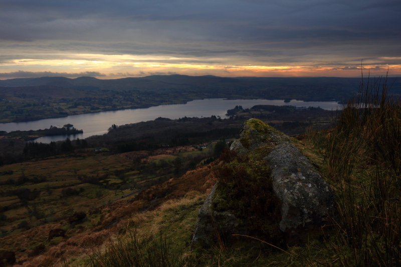
I had the benefit of the sunrise on the way up, but the clouds closed in earlier than expected, and most of the ascent, and the entire time on the summit and way down was spent in heavy rain. This obscured the views, but I could see enough to tell that in good light, the views towards Donegal Town, and towards the rest of the Bluestacks could be wonderful. The best views would probably be over Lough Eske, and on a good day would no doubt be spectacular.

Well worth a visit, with a real feeling of isolation once amidst the rocks on the broad summit area. Linkback: mountainviews.ie/summit/1067/comment/17845/
Read Less
Read More

Better road surface - easier access now
by Pepe 17 Jan 2018
Followed the Bluestack Way sign mentioned by Aidy. The road is well surfaced now, though narrow. Drove a couple of kilometres NW (ignoring lower-down parking areas) to a small plantation on the left. Drive on a 100 metres or so and you'll find a parking spot on your right. Walk back down that 100 metres of road to the corner of the plantation. Step over a little mountain brook and from there it's an easy 20 minutes to the flattish summit area with only a short steep section to be negotiated. Head south across the plateau up top, keeping Sand Lough to your right, and you'll soon reach the little cairn. The round trip from this upper parking spot comes in at about an hour. Great views to be had over Lough Eske and the Bluestacks. Linkback: mountainviews.ie/summit/1067/comment/19842/
Read Less
Read More
EDIT Point of Interest
text
Videos


Recent Contributions
x
Conditions and Info
Use of MountainViews is governed by conditions and a privacy policy.
Read general information about the site.
Opinions in material here are not necessarily endorsed by MountainViews.
Hillwalking is a risk sport. Information in comments, walks, shared GPS tracks or about starting places may not be accurate for example as regards safety or access permission. You are responsible for your safety and your permission to walk.
See the credits and list definitions.

OSi logo
OSNI/LPS logo
Open Street Map
(Various variations used.)
British summit data courtesy:
Database of British & Irish Hills