Donation Request 2024

DONATE
Members and Supporters, the MountainViews Committee requests your help to meet the costs of the website and of other activities such as insured events or publications.
You do not have to be logged in to donate.
Features
Nearby features appear when you click the map.
Declutter tracks on map.
Place Search
Video
X
Pub: by
Mangerton Area , Cen: Mangerton Subarea
Feature count in area: 28, all in Kerry, OSI/LPS Maps: 78, 79, EW-KNP, EW-R
Highest Place: Mangerton 838.2m

Starting Places (30) in area Mangerton:
Cummeenboy Stream, Derrycunihy Church, Dunkerron Mid, Garries Bridge, Gowlane School Ruin, Hidden Valley Pet Farm, Inchimore West, Kenmare Bridge, Killarney Hiking Parking Lot, Knockanaskill N, Knocknsallagh Bridge, Loo River Junction, Looscaunagh Lough W, Lough Barfinnihy CP, Lough Guitane E, Lough Guitane SE, Lough Guitane W, Lynes Farm, Mangerton Walk N CP, Mangerton Walk Start, Molls Gap, Muckross Lake S, Old Rail Level Crossing, Poulacapple, River Roughty, Rossacroo na Loo Forest, Sahaleen Bridge, Shaking Rock W, Shronaboy Farm MTB, Torc Waterfall CP

Summits & other features in area Mangerton:
Cen: Dromderlough: Dromderalough 650m, Dromderalough NE Top 654m, Dromderalough NW Top 625m, Knockbrack 610m, Knockrower 554m, Shaking Rock 402m
Cen: Inchimore: Inchimore 256m
Cen: Mangerton: Glencappul Top 700m, Mangerton 838.2m, Mangerton North Top 782m, Stoompa 705m, Stoompa East Top 608m
NE: Crohane: Bennaunmore 454m, Carrigawaddra 425m, Crohane 650m, Crohane SW Top 477m
NW: Torc: Cromaglan Mountain 371m, Torc Mountain 534.8m, Torc Mountain West Top 479.4m
SE: Esknabrock: Esknabrock 406m
SW: Peakeens: Derrygarriff 492m, Derrygarriff West Top 382m, Foardal 409.8m, Knockanaguish 509m, Peakeen Mountain 554.7m, Peakeen Mountain Far NW Top 525.5m, Peakeen Mountain North-West Top 522.7m, Peakeen Mountain West Top 538.7m

Note: this list of places may include island features such as summits, but not islands as such.
Rating graphic.
Stoompa, 705m Mountain Stumpa A name in Irish,
Place Rating ..
(prob. Ir. Stumpa [PDT], 'stump'), Kerry County in Munster province, in Arderin, Vandeleur-Lynam Lists, Stoompa is the third highest mountain in the Mangerton area and the 106th highest in Ireland.
Grid Reference W00648 81782, OS 1:50k mapsheet 79
Place visited by: 256 members, recently by: rhw, DeirdreM, orlaithfitz, Carolineswalsh, ToughSoles, daitho9, Krzysztof_K, Beti13, bagoff, NualaB, Hjonna, abcd, SmirkyQuill, mlmoroneybb, Barrington1978
I visited this place: NO (You need to be a logged-in member for this.)
Longitude: -9.446618, Latitude: 51.979784, Easting: 100648, Northing: 81782, Prominence: 90m,  Isolation: 1.1km
ITM: 500624 581847
Bedrock type: Green sandstone & purple siltstone, (Glenflesk Chloritic Sandstone Formation)
Notes on name: This outlier of Mangerton overlooks Lough Guitane.
  Short or GPS IDs, 6 char: Stompa, 10 char: Stoompa

Linkback: https://mountainviews.ie/summit/105/
Gallery for Stoompa (Stumpa) and surrounds
Summary for Stoompa (Stumpa): This is a trek worth making
Summary created by jackill, scapania 2011-07-09 21:21:09
            MountainViews.ie picture about Stoompa (<em>Stumpa</em>)
Picture: Stoompa in the centre from the far end of the Horses glen
From Killarney take the Kenmare road as far as Muckross and then take the first sharp left after Molly Darcy's pub. Drive uphill to a fork in the road with a sign for Mangerton. Take the road to the right and drive along this road until you see a rough track heading off to the left ( Mangerton Walk Start (V984 848)) just after a track on the right. There's plenty of parking here along the road or at the start of the track.

This track will take you to the Devil's punchbowl. The start of the walk presents you with a gradual climb as the track meanders either side of a largely dry riverbed. The Lakes of Killarney emerge spectacularly on your right as you gradually gain height. The track winds on upwards until you eventually reach the punchbowl.You then turn right and climb above the western ridge with a precipitous drop to your left and bear south west for Mangerton's summit. From Mangerton cross north east to the cliff edge , there is a faint track skirting the corries as you turn east, then north at the lowest point to Stoompa.The bog has been eroded along this edge so it makes for easier walking.
Be very aware of the cliffs to your left. This is the area where a Swedish walker fell to his death in 2006.

To return to your starting point, head north from the summit, over a subsiduary top and steeply down to the outflow of L. Garygary. From here head west along a rough, heathery shelf to rejoin the Punchbowl track near A (V984 839).
Linkback: mountainviews.ie/summit/105/comment/4865/
Member Comments for Stoompa (Stumpa)
Comment create / edit display placeholder

            MountainViews.ie picture about Stoompa (<em>Stumpa</em>)
NIce Hike with great Views
by marzka 30 Mar 2015
Stoompa has a nice view towards Magnetron North and I believe it must be done in loop walk with reaching Mangeron North as this allow to see Stoompa from another site.
Start with the normal route up to Mangerton and at the hight about 210m take a heading east toward the Horses Glen. This part might be a bit wet. Pass the stream – it seems to me that the best place is near lake Garagarry and fallow the slope to the top. Stoompa has a great views behind over Killarney town, Muckross and the Lakes to the NW and W, with the Paps, Lough Guitane, Crohane and the Derrynasaggart mountains to NE, E and SE.
Then fallow the circle of Glen toward Mangerton. Here you can see the Roughty Valley and Kenmare Bay with the Reeks and Purple. Then I would recommend go to Mangerton North by steeply spur that divides the Devils Punchbowl (on left) and the Horses Glen (on right). And then descend from punchbowl via gentle normal route for our decent
Duration: 5-6h
Difficulty: Moderate
Start Point: it's about 5 miles from Kilarney. From town take theN71 ( to Kenmare).. Look for the signs 'Mangerton' Linkback: mountainviews.ie/summit/105/comment/17897/
Read Less
Read More

            MountainViews.ie picture about Stoompa (<em>Stumpa</em>)
Picture: The Horses Glen
Coordinate errors
by jackill 8 May 2021
We parked the car at GR Mangerton Walk N CP (V98412 85728) on a fine July evening and walked the first kilometre on the roadway before turning left onto the rough path that follows the side of the Finoulagh River for a time and eventually leads to the Devils Punch Bowl. We pitched the tent at the mouth of the Punch Bowl GR B (V97566 81734) and settled down for the night with the stars overhead and the light of Killarney flickering below in the distance. Up at 6 am for a fry and coffee and walking towards Mangerton North Top by 7.30 am. Mangerton North is rounded and featureless marked by a small cairn. From here we moved on to Glenacappul Top passing a curious fenced off square of overgrown mountain. We guessed this to be an experiment on the effects of sheep on the mountain, all I have to say is that if the grass could get that high with no sheep long live sheep!. I took a GPS height of 702 meters for this top and 686 meter for the col to Mangerton North which makes me ask is it an independent summit?
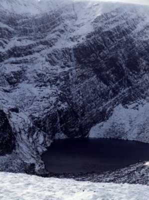
We then doubled back the way we had came and headed up the steep slope between the Punch Bowl and Lough Erhogh to Mangerton Mountains summit and radio mast.
The summit area is broad ,flat and boggy(in July!). To get any views worth speaking of you have top walk to the edges of the summit area.
We headed down the long sweeping ridge on the well worn track towards Stoompa.
At this stage of the morning the sun was burning off the last of the mist and the heat was rising, out with the factor 30. On the way we passed many rough, angular, loose rock formations with little rounded scallops taken out.
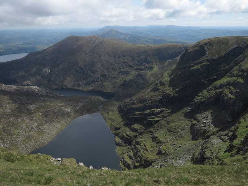
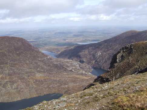
The top of Stoompa is marked by a cairn and excellent views of Crohane, the Paps, the lakes of Killarney and indeed the Glacial Corries of Lough Erhogh, Lough Managh and Lough Garagarry. We descended towards Lough Garagarry from Stoompa passing what looked like a passage tomb on the right( not marked on the maps) and after hopping across the stones at the mouth of the Owgarriff River cooled off with a wash in the lake – I never enjoyed water so much.
We then crossed some rough ground (keeping above the marsh) back to the Punch Bowl path down to the car. 20 kms , 8hrs and two Guinness in Killarney.
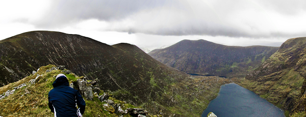
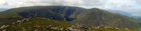
The photo was taken on the summit of Stoompa with from the right, Glenacappul Top and Mangerton North Top with their towering walls of lava and volcaniclastic rock facing the viewer, the glacial corrie of Lough Erhogh gouged out under the sandstone cliffs and the broad hulking mass of Mangerton Mountain sweeping down towards Stoompa. Linkback: mountainviews.ie/summit/105/comment/2457/
Read Less
Read More

            MountainViews.ie picture about Stoompa (<em>Stumpa</em>)
Picture: Lough Erhog from Stoompa
dexterg on Stoompa
by dexterg 5 Mar 2009
A cold view of the lake from the top of Stoompa looking west. A contrast with Becketts pic below from a couple of years ago. The Climb up Stoompa in the snow certainly makes you work for your lunch! Fern & Dex Linkback: mountainviews.ie/summit/105/comment/3619/
Read Less
Read More

            MountainViews.ie picture about Stoompa (<em>Stumpa</em>)
Picture: Stoompa
Lynchieboy on Stoompa
by Lynchieboy 15 Apr 2006
Beautiful day today. Took in Mangerton the customary way, then Glencappul SE then motored on to do the two Stoompas to go and see my old friends Bennaunore and Crohane. Views from the Paps to Caher. Beautiful. Came home by descending Stoompa and shot up Glencappul. This is visible as the valley on the right of the picture. From there walked along the ridge until it met the one for the punchbowl and rolled away home. Great day's climbing. Five hours flat out walking, running, jumping, climbing, leaping etc. Linkback: mountainviews.ie/summit/105/comment/2270/
Read Less
Read More

            MountainViews.ie picture about Stoompa (<em>Stumpa</em>)
Picture: Stoompa from Mangerton
dexterg on Stoompa
by dexterg 5 Mar 2009
We did the Stoompa/Mangerton walk clockwise on Feb 10th last in the snow. The circuit had good powder all round making for very interesting trip of approx 6 hours It was one of those awesome days where in the cold hard air the views are more striking and the colours are vivid. The Kerry hills never looked better. I have one or 2 more pics that i could post when i work out how to do this. Dex & Fern (Cork) Linkback: mountainviews.ie/summit/105/comment/3618/
Read Less
Read More
EDIT Point of Interest
text
Videos


Recent Contributions
x
Conditions and Info
Use of MountainViews is governed by conditions and a privacy policy.
Read general information about the site.
Opinions in material here are not necessarily endorsed by MountainViews.
Hillwalking is a risk sport. Information in comments, walks, shared GPS tracks or about starting places may not be accurate for example as regards safety or access permission. You are responsible for your safety and your permission to walk.
See the credits and list definitions.

OSi logo
OSNI/LPS logo
Open Street Map
(Various variations used.)
British summit data courtesy:
Database of British & Irish Hills