Donation Request 2024

DONATE
Members and Supporters, the MountainViews Committee requests your help to meet the costs of the website and of other activities such as insured events or publications.
You do not have to be logged in to donate.
Features
Nearby features appear when you click the map.
Declutter tracks on map.
Place Search
Video
X
Pub: by
Antrim Hills Area , N: North Antrim Hills Subarea
Feature count in area: 27, all in Antrim, OSI/LPS Maps: 14, 15, 4, 5, 8, 9
Highest Place: Trostan 550m

Starting Places (3) in area Antrim Hills:
Donalds Carn, Rathlin Island Ferry Port, Whitehead Golf Club

Summits & other features in area Antrim Hills:
Cen: Central Antrim Hills: Carncormick 436m, Collin Top 429m, Crockalough 402m, Mid Hill 440m, Skerry Hill 459m, Slieveanorra 508m, Slievenahanaghan 418m, Soarns Hill 403m, Tievebulliagh 402m, Trostan 550m
Central Antrim Hills: Slievenanee 543m
N: North Antrim Hills: Carnanmore 379m, Croaghan 417m, Crockaneel 403m, Cross Slieve 206m, Knocklayd 514m, Lannimore Hill 207m
N: Rathlin Island: Kilpatrick (Rathlin Island) 134m
S: Islandmagee: Donalds Carn 141m, Muldersleigh Hill 131m
S: South Antrim Hills: Agnew's Hill 474m, Big Collin 353m, Black Hill 381m, Carnearny 319m, Douglas Top 402m, Slemish 437.9m
W: West Antrim: Long Mountain 215m

Note: this list of places may include island features such as summits, but not islands as such.
Rating graphic.
Cross Slieve, 206m Hill Croisshliabh A name in Irish,
Place Rating ..
(Ir. Croisshliabh [OSNB*], 'cross mountain'), Antrim County in Ulster province, in Binnion Lists, Cross Slieve is the 1390th highest place in Ireland.
Grid Reference D23700 29500, OS 1:50k mapsheet 5
Place visited by: 30 members, recently by: Paddym99, garybuz, Claybird007, Portosport, Kilcoobin, LorraineG60, MichaelG55, eamonoc, eejaymm, m0jla, Ulsterpooka, trostanite, hivisibility, jimmyread, Fergalh
I visited this place: NO (You need to be a logged-in member for this.)
Longitude: -6.063063, Latitude: 55.097337, Easting: 323700, Northing: 429500, Prominence: 150m,  Isolation: 5.1km
ITM: 723621 929482
Bedrock type: Conglomerate and (subequal/subordinate) sandstone, (Cross Slieve Group)
Notes on name: This name may signify 'cross mountain' in the sense 'transverse', but since this does not seem to suit the topography, it may rather be due to a cross once located on it.
  Short or GPS IDs, 6 char: CrsSlv, 10 char: CrsSlv

Linkback: https://mountainviews.ie/summit/1034/
Gallery for Cross Slieve (Croisshliabh) and surrounds
No summary yet for this place .
Member Comments for Cross Slieve (Croisshliabh)
Comment create / edit display placeholder

            MountainViews.ie picture about Cross Slieve (<em>Croisshliabh</em>)
Picture: A quiet resting place at Layd Church
Circular walk from Cushendall
by gerrym 4 Nov 2011
Starting point at beach in Cushendall (A (D241 280)) in company of golfers, children playing in the park, sea air and the noise of waves crashing.

Follow the rough lane uphill and turn off right on a green track which drops and rises to the cliff path, giving great views over the beach and across the bay to bigger hills. Numerous landslips have eaten to the edge of the path in places giving the path a precarious feel.

The path turns inland at a steep gully. A faint and overgrown track heads off downhill to the storm beach at Port Obe below. This is well worth a diversion and i disturbed 2 herons as I passed by an impressive waterfall coming down the gully and flowing out to sea. A nice bit of lunch on rocks with waves lapping at my feet before i headed back uphill.

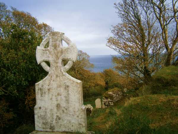
Continued on the path and was met by barriers with 'cliff path closed' signs which had not been present at the other end! OOPS!! Layd Church presents itself and is a pleasant sight surrounded by trees and the stream bordering its edge. Established in 1306 it is well worth exploring the church and memorials which look out to sea.

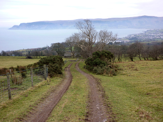
Continue uphill past a carpark with stunning views, turn right onto the road and follow for 5 minutes before turning left and going uphill to reach the strangely located Glenville caravan park.

A farm track (mentioned elsewhere here) has a gate with 'beware of bull'. A farmer was out in the fields in his 4x4 and a chat confirmed that it was okay to follow the track which goes all the way to the summit. It also confirmed that it was always good to ask and give respect! I gave a herd of cows a wide berth as i went uphill past old farm buildings.

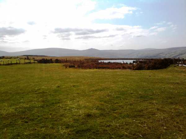
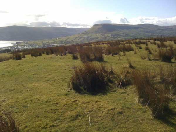
Views open out dramatically and the top is reached in an hour. Even on a dull day the views up 5 of the the Glens to higher tops were fine as were those out to sea. A pair of buzzards circled and rose on the winds ever higher above me. A fairly short walk brings the second slightly lower top and little Ellen's Lough.

Drop down to the 2 transmitter masts and take the lane to the road. This drops gently back into Cushendall for the next half hour, with the other end of the rough lane (B (D241 284)) providing a short cut back to the carpark.

A beautiful walk of 2 hours from coast to hill and back on cliff paths, quiet roads and farm tracks. Beautiful sights all the way and some good local history to explore. But beware the bull if he is there!! Linkback: mountainviews.ie/summit/1034/comment/6610/
Read Less
Read More

            MountainViews.ie picture about Cross Slieve (<em>Croisshliabh</em>)
Picture: Looking back to Cushendall and the Antrim Plateau from the track up to Cross Slieve
Harry Goodman on Cross Slieve
by Harry Goodman 27 Jan 2010
As Cross Slieve was the only top in the Antrim Hills MV list that I had not climbed I took advantage, when in the area on 26 Jan 2010 to climb Croaghan, to complete my list. Having noted slemish's comments that the summit is on private farmland and is therefore inaccessible, I sought access by walking up a rough farm track from C (D23836 28898). This leads to the summit and it was my intention to seek permission at the farm house marked on the map some distance up. Initially I passed through an unlocked steel gate. When I arrived at the farmhouse I found it had long been deserted and in a ruined state. I continued up the track to it's end on the flat top of the hill. The high point (206m) lies some 125m to the left (W) at D (D237 295) at a fence junction. The land here is so flat that many points within a 100 x 100 metre square could (visually) be the high point! When I was there I crossed over a stile near the end of the track, on the right and made my way across to the lesser highpoint shown on the map as 203m and from there out to tiny Ellens Lough before re-tracing my steps back to track. A brisk walk up and down this little hill would take 20 minutes or so, but once there my wanderings extended my time to about 55 minutes. Back at the car I met a local man who advised me that the owner of the land lived in the house some 150 metres back along the road. I called at the house and advised that I had been up the track to the top and had intened to ask permission at the farm house, only to find it deserted. The lady to whom I spoke had no objections to what I had done. Apart from passing through one gate on the way to the top of Cross Slieve by this route there is no need to cross any barriers. One final point regarding slemish's comment about "private farmland" and "accessability". The vast majority of upland areas are privately owned but access to the hills in most areas is not a problem. If in doubt seek permission. Linkback: mountainviews.ie/summit/1034/comment/4376/
Read Less
Read More

            MountainViews.ie picture about Cross Slieve (<em>Croisshliabh</em>)
Picture: Looking south-west from Cross Slieve to Trostan and Tievebulliagh
northern summit
by slemish 16 Apr 2010
I had previously claimed on MV that the summit of Cross Slieve was on private farmland. This advice had been given to me by a Cushendall resident and I never thought to question it. Thanks to Harry Goodman's efforts however we have discovered that Cross Slieve is actually very accessible. For the sake of variety, I decided to climb to the northern 'second summit' which is only a few metres lower than the 206m main summit - although the whole summit area of Cross Slieve is so flat it makes very little difference. I parked at the bottom of the access path to the mobile phone transmitter on the Layde road between Cushendall and Knocknacarry (E (D245 305)). From here you go up the path and into the field behind the transmitter. Climb over the farm gate at the back of this field and you will see a small lake known as Ellen's Lough ahead. The 203m summit is just to the left of this lake. Great views from here up Glenballyeamon towards Lurigethan, Trostan, Tievebulliagh and Slieveanorra. Looking out to sea, you can easily pick out the Scottish coast and various isles across the North Channel. If visiting the area be sure to take in the nearby ancient ruins of Layde church and the little 'fairy-hill' of Tieveragh on the southern side of Cross Slieve. Like Slemish, this is an extinct volcanic plug and from the south looks just like a miniature version of Lurigethan which it directly faces. I returned to the car by way of ascent. This is a very easy walk - I was up and down in less than 20 minutes. Linkback: mountainviews.ie/summit/1034/comment/4625/
Read Less
Read More

            MountainViews.ie picture about Cross Slieve (<em>Croisshliabh</em>)
Picture: Looking towards Lurigethan from the slopes of Cross Slieve
three5four0 on Cross Slieve
by three5four0 28 Mar 2010
I read Harry Goodman's comments on Cross Slieve, whilst the wind battered the outside of the Hostel we were staying in. In one memorable incident, it lifted an old brandy barrel - which had been weighed down with blocks - right up into the air and towards a parked van, causing much panic in the immediate vicinity. But then Patagonia summers are like that.

With Cross Slieve being the last MV summit in the Antrim Hills section and my last local 100 hill that i had to complete, i was naturally keen to get going, once I returned from the southern hemisphere that is. Spoke to the Lady at the farm house and all was well for an ascent. I followed Harry Goodman's route, up the track to the summit area. I agree with his comments regarding the highest point, perhaps erring towards the slight rise to the left of the spot height and the fence junction. Where a fence runs SSE with an open gate in it, this would of course be entirely within the margin for error in a 1:25000 map.

Walked out to the other 200 metre top , past some dead sheep, and over a small foot stile and another fence. The altimeter confirmed this area as 200 metre and I returned by the way of ascent for some celebratory pints of Guinness in McBrides in Cushendun.i Linkback: mountainviews.ie/summit/1034/comment/4544/
Read Less
Read More
EDIT Point of Interest
text
Videos


Recent Contributions
x
Conditions and Info
Use of MountainViews is governed by conditions and a privacy policy.
Read general information about the site.
Opinions in material here are not necessarily endorsed by MountainViews.
Hillwalking is a risk sport. Information in comments, walks, shared GPS tracks or about starting places may not be accurate for example as regards safety or access permission. You are responsible for your safety and your permission to walk.
See the credits and list definitions.

OSi logo
OSNI/LPS logo
Open Street Map
(Various variations used.)
British summit data courtesy:
Database of British & Irish Hills