This website uses cookies, which are small text files that the website puts on your device to facilitate operation. Cookies help us provide a better service to you. They are used to track general user traffic information and to help the website function properly.
Feature count in area: 57, by county: Cork: 32, Kerry: 36, of which 11 are in both Cork and Kerry,
OSI/LPS Maps: 83, 84, 85, 88
Highest Place: Hungry Hill 682m
Starting Places (51) in area Caha Mountains: Ardgroom, Barley Lake North, Bere Island Pier, Caha Pass, Canshanavoe South, Carriganine, Cashelkeelty Stone Circles Carpark, Castletownbere Lifeboat Harbour, Clashduff River Farm, Coolieragh Harbour Road, Coomadayallig Lake Road N, Coomadayallig Lake Road S, Cooryeen Lane, Cummer Lough East Road, Derreenataggart Stone Circle Road, Dromoghty Lough North, Dunboy Wood, Esk Boreen, Eyeries, Fehanah Lane, Garinish Island Pier, Glantrasna Bridge, Glenbeg Lough N, Glengarriff, Glengarriff Nature Reserve CP, Gleninchaquin Waterfall, Gowlaun Lough, Healy Pass, Healy Pass Hairpin, Ilnacullin Car Park, Kenmare Bridge, Knockacullin Lane, Leahill Bog, Leitrim Beg Standing Stone, Lough Inchiquin SE, Magannagan Stream, Molly Gallivan's Visitor Centre, Nora's Cottage, Old Lansdowne School, Owgarriff River Lane, Peg's Shop, Pooleen Wood Car Park, Red Trout Lake, Reenroe Bridge, River Drimminboy Track, Rossmackowen Bridge, Rossmackowen Cemetery, Shronebirrane Farm, Shronebirrane Road, Toberbanaha, Turner's Rock Tunnel
Summits & other features in area Caha Mountains: Cen: Hungry Hill: Coombane 510m, Derryclancy 554m, Hungry Hill 682m Cen: Knockowen: Cushnaficulla 594m, Glenkeel Top 417m, Knockastumpa 398m, Knockeirky 577m, Knockeirky South Top 523m, Knockowen 658m, Stookeennalackareha 412m E: Glengarriff: Derrynafulla SW 375m, Gowlbeg Mountain 362m, Nareera 530m, Nareera North Top 503m, Nareera South-West Top 505m, Shrone Hill 283m, Sugarloaf Mountain 574m, Sugarloaf Mountain Far West Top 560m, Sugarloaf Mountain West Top 565m N: Coomnadiha: Baurearagh Mountain 489m, Caha Far SE Top 555m, Caha SE Top 585m, Coomnadiha 644m, Coomnalack Top 435m, Cummeenbaun 510m, Droppa 522m, Killane Mountain 537m, Killane Mountain South-West Top 533m, Knockagarrane 414m, Knockreagh 500m N: Knockeirka: Barraduff Mountain 400m, Killaha Mountain 400m, Knockeirka 426m N: Knocknagorraveela: Derrysallagh 410m, Feorus East 474m, Knocknagorraveela 507m, Knocknagorraveela NE Top 464m N: Lauragh: Knockanoughanish 386m, Knockatee 330m S: Castletownbere: Disert 205m, Knockanallig (Bear Island) 267m W: Ardgroom: Derryvour Hill 160m W: Eskatarriff: Coomacloghane 599m, Eskatarriff 600.5m, Eskatarriff East Top 532.7m, Knocknaveacal North Top 509.1m, Knocknaveacal South Top 507.2m, Lackabane 603m, Tooreenbaha 408.7m, Tooreennamna 524m, Tooth Mountain 592m W: Knocknagree: Knocknagree 586m, Knocknagree East Top 461m, Knocknagree SE Top 442m, Lackawee 572m, Maulin 621m, Maulin North Top 579m
Note: this list of places may include island features such as summits, but not
islands as such.
Cushnaficulla, 594mMountain Cois na Fiacaile A name in Irish,
Place Rating ..
(Ir. Cois na Fiacaile [T6000], 'beside the tooth'), Cork/ Kerry County in Munster province, in Arderin Lists, Cushnaficulla is the 305th highest place in Ireland.
Grid Reference V82190 55899,
OS 1:50k mapsheet 84 Place visited by: 95members, recently by: maoris, Oscar-mckinney, Carolyn105, Jai-mckinney, Kirsty, NualaB, nupat, Sweeney, miriam, jackos, Superterence, srr45, Geo, John.geary, jimmytherabbit
I visited this place: NO (You need to be a logged-in member for this.)
Longitude: -9.706017, Latitude: 51.7435, Easting: 82190, Northing: 55899,
Prominence: 59m, Isolation: 1km ITM: 482190 555950 Bedrock type: Purple & green sandstone & siltstone, (Caha Mountain Formation) Notes on name: Along with Tooth Mountain, Knocknaveacle, Keecragh and Hungry Hill (Daod), this is yet another Caha hill-name relating to teeth or eating.
Short or GPS IDs, 6 char: Cshnfc, 10 char: Cshnfcl Linkback: https://mountainviews.ie/summit/287/
Gallery for Cushnaficulla (Cois na Fiacaile) and surrounds
Summary
for Cushnaficulla (Cois na Fiacaile):
Twin peaks
Summary created by jackill
2010-10-31 11:43:14
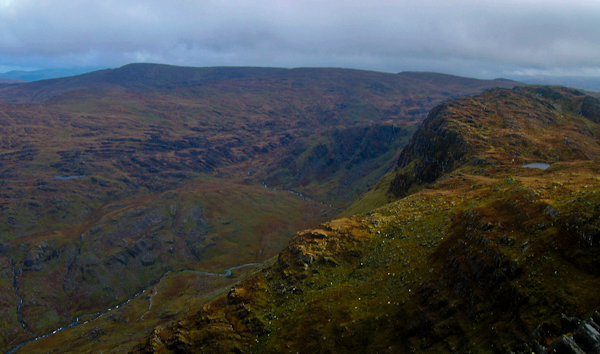
Picture: Cushnaficulla to the right with Lough Namuinna
Park at Healy (V78640 53567), room for 3 cars. If the shop is closed parking is also possible at V7A (V8656 5346). There is a rough track leading east from the highest point of the pass.Pick your way upwards around easy, rock shelfs onto a level rocky ridge. As you leave this ridge look for a grassy slope on the side of Knockowen to ascend to the summit cairn on a low rock shelf.
Carry on from Knockowen to Cushnaficulla.
There are two possible summits on top of rocky shelves.The discovery series OSI maps them as 594 and 596 meters, however the old 6 inch maps lists both at 1942 feet(approx. 592 mtrs).
GPS readings on both suggest equal heights of 597 meters.
Better climb both then
On my way to investigate the claims for Knockeirys exclusion in the Arderins list, I naturally took in Knockowen and Cushnaficulla on the way there. Whilst pondering in my mind, that it probably was not a good idea to stay in a certain well known pub to the small hours of the morning, and then go hillwalking the next day, let alone to do it 7 nights in a row. I noticed that whilst my map, and the MV listed the spot height as 594m and on the West top, my Satamap software gave a second spot height of 596m on the East top of Cushnaficulla. So, not only a gain of 2 metres, but a move to the east for the summit! As the mapping is supplied to Satamap by OSI, does the new series maps have this extra spot height on them? And more to the point has anyone just visited the east top and not the west?, no sniggering at the back there! Linkback: mountainviews.ie/summit/287/comment/5998/
Read Less
Read More
simon3 on Cushnaficulla
by simon3
5 Aug 2003
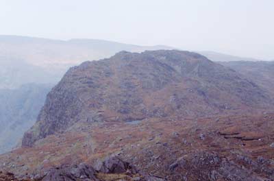
Richard Mersey [The Hills of Cork and Kerry] “.. it is worth going to the Northern peak [of Cushnaficulla] and peering into the depths of Glenrastel, now over 1,500 feet vertically below you. Cushnaficulla, indeed, has a magnificent north face that is the steepest in Beara.” The photo shows this view – I am sure you will agree that it is impressive. Linkback: mountainviews.ie/summit/287/comment/604/
Read Less
Read More
simon3 on Cushnaficulla
by simon3
5 Aug 2003
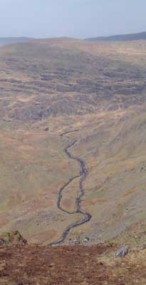
This is a picture of Cushnaficulla from its West. The little lake visible in the picture is Lough Namuinna, supposedly a great place to swim if you don’t mind cold water. Linkback: mountainviews.ie/summit/287/comment/605/
Read Less
Read More
Picture: Wild and wonderful
The View North
by CaptainVertigo
7 Jun 2016
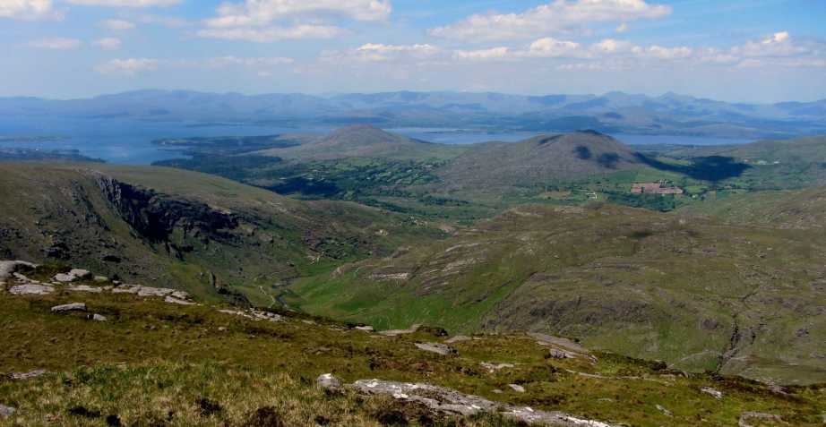
One of the features of the ridge walk from Knockeirky to Knockowen over Cushnaficulla is the view north to Kenmare Creek. The middle of the photo shows Coomeenbaun . To the left can be seen the slopes of Knockowen running north east. The bay/inlet behind Knockowen is Kilmakilloge Harbour (the village of Lauragh is obscured from view)
The mountains in mid picture before Kenmare Creek are Knockatee on the left (330) and Knockanoughanish on the right (386).
The views south are equally magnificient.
I had walked from Nareera over rough country, so the ridgeline of the Cork/Kerry border came as a relief. Linkback: mountainviews.ie/summit/287/comment/18572/
Use of MountainViews is governed by conditions and a privacy policy.
Read general information about the site. Opinions in material here are not necessarily endorsed by MountainViews.
Hillwalking is a risk sport. Information in comments, walks, shared GPS tracks or about starting places may
not be accurate for example as regards safety or access permission. You are responsible for your safety and your permission to walk.
See the credits and list definitions.


 Our Facebook page.