Cookies.
This website uses cookies, which are small text files that the website puts on your device to facilitate operation. Cookies help us provide a better service to you. They are used to track general user traffic information and to help the website function properly.
Features
Nearby features appear when you click the map.
Declutter tracks on map.
Place Search
Video
X
Pub: by
Breifne Area , N: Cuilcagh Mountains Subarea
Feature count in area: 14, by county: Fermanagh: 4, Cavan: 8, Leitrim: 3, of which 1 is in both Cavan and Fermanagh, OSI/LPS Maps: 26, 27, 27A
Highest Place: Cuilcagh 666m

Starting Places (15) in area Breifne:
Aghnacollia Lane, Bellavally Gap, Bencroy, Corneen Wind Farm, Corrawully Lane, Cuilcagh Boardwalk Trail, Dowra, Dowra Sweat House Lane, Glangevlin Cross, Gortalughany Viewpoint, Mullaghgarve Waterfall, Rock Road, Spa Well, Tulliniska Transmitters, Tully Lough

Summits & other features in area Breifne:
N: Cuilcagh Mountains: Benaughlin 370m, Benbeg 539m, Cuilcagh 666m, Mullaleam 424m
NE: Derrylin: Knockninny Hill 191m, Slieve Rushen 404m
SW: Iron Mountains: Bencroy 518m, Knockacullion 562m, Slieve Anierin 585m
W: Benbrack: Bartonny Top 411m, Benbrack 502m, Benbrack NE Top 496m, Benbrack West Top 463m, The Playbank 542m

Note: this list of places may include island features such as summits, but not islands as such.
Rating graphic.
Cuilcagh, 666m Mountain Binn Chuilceach A name in Irish,
Place Rating ..
(Ir. Binn Chuilceach [DUPN], 'chalky peak') County Highpoint of Cavan & Fermanagh and in Cavan/ Fermanagh counties in Ulster province, in County Highpoint, Arderin, Vandeleur-Lynam, Irish Highest Hundred Lists, Cuilcagh is the highest mountain in the Breifne area and the 168th highest in Ireland. Cuilcagh is the highest point in county Cavan and also the highest in Fermanagh.
Grid Reference H12356 28017, OS 1:50k mapsheet 26
Place visited by: 572 members, recently by: Marykerry, eimirmaguire, maryblewitt, michaelseaver, chelman7, rhw, claireod5, gdg, purpleknight, discovering_dann, Combat_Monkey, Carolineswalsh, knightsonhikes, JordanF1, MarionP
I visited this place: NO (You need to be a logged-in member for this.)
Longitude: -7.811428, Latitude: 54.201026, Easting: 212356, Northing: 328017, Prominence: 570m,  Isolation: 2.6km, Has trig pillar
ITM: 612303 828028
Bedrock type: Cyclothemic sandstone, siltstone, coal, (Lackagh Sandstone Formation)
Notes on name: Cuilcagh lies on the Shannon-Erne watershed. The Shannon rises on the north-western slopes of Cuilcagh at Shannon Pot, a steep-sided pool where the underground river emerges. Strictly speaking, there are streams a mile or two further uphill. Originating in Ulster, the Shannon’s journey through this province lasts less than ten miles, before it enters Connacht. It forms the boundary between Connacht and Leinster for much of its length, and ultimately meets the sea in the province of Munster. Thus it is both a boundary and a link between all four provinces of Ireland. In fact, it even formed the western boundary of the ancient fifth province of Meath. Around Cuilcagh there is a belief concerning the ‘Northern Shannon’, an underground river that supposedly connects the waters at Shannon Pot to the River Claddagh, which emerges at Marble Arch Caves and then flows into the Erne. If Cuilceach genuinely is a variant of cailceach, 'chalky', the name is rather puzzling, as the mountain consists predominantly of sandstone and shale, covered with much bog and heather. Where the rock does outcrop, as at the summit cliffs, it is mainly grey. However, it is possible that the name refers to the limestone rock on the lower northern flanks. Here a number of streams disappear below ground at swallow holes named Cats Hole, Pollawaddy, Pollasumera and Polliniska, all forming part of the Marble Arch cave system. If so, the name would mean 'calcareous' rather than 'chalky'.
  Short or GPS IDs, 6 char: Clcgh, 10 char: Cuilcagh

Linkback: https://mountainviews.ie/summit/165/
Gallery for Cuilcagh (Binn Chuilceach) and surrounds
Summary for Cuilcagh (Binn Chuilceach): Popular bulky mountain sitting in splendid isolation on the Border
Summary created by markmjcampion, Peter Walker 2023-05-18 15:05:49
            MountainViews.ie picture about Cuilcagh (<em>Binn Chuilceach</em>)
Picture: Cuilcagh from the ridge to Benbeg
Cuilcagh is a huge sprawling mountain of genuine geographical significance: it's the highest point on the border as well as the highest point in both Cavan and Fermanagh and the source of the Shannon lies on its slopes. It presents a conspicuous roof-like appearance from the north-east and south-west, and while much of its area is blanket bog and tough moorland, the mountain's edges are often starkly scarped. There are extensive views of border country and many lakes from the top.

N. Park near Marble Arch caves at Cuilcagh Boardwalk Trail (H12056 33493) and head S on the Legnabrocky Trail, a gravel track that gives way to an obvious boardwalked section higher up. This stops when you reach the summit plateau and a 1km waymarked stroll will take you to the summit. 1.5hrs+

S. Park at A (H11911 24495) and walk a few metres E to the forest entrance. Head along forest tracks to the transmitter just below Benbeg's summit, pass the enclosure on its right before a short climb leads up to the ridge from where the majestic E-facing scarp is followed on intermittent paths (and considerable muck) to the top of Cuilcagh with its trig column and huge tumulus. 1hr 45m+

NE. Start from the Gortlughany Viewpoint CP Gortalughany Viewpoint (H16770 30037) and follow markers for the Ulster Way. Take a left at B (H15761 30834) and follow boggy ground to the summit. 2 hrs

W. Park in Glangevlin Spa (H07225 27508) and head NE to the summit plateau, passing the cliffs of Tiltinbane. 2hrs+

Notable tracks incl. track/2633, track/3354 and track/3175.
Linkback: mountainviews.ie/summit/165/comment/4925/
Member Comments for Cuilcagh (Binn Chuilceach)
Comment create / edit display placeholder

            MountainViews.ie picture about Cuilcagh (<em>Binn Chuilceach</em>)
Picture: Lough Atona
North and South: Geopark odyssey
by kernowclimber 1 Aug 2011
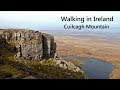
Cuilcagh is the only county top to straddle Northern Ireland and the Republic of Ireland and, lying on the boundary between counties Fermanagh and Cavan, is also part of the world’s first international Geopark: the Marble Arch Caves Global Geopark (2008). Cuilcagh’s distinctive table top plateau is comprised of gritstone, uncommon in Ireland, eroded into dramatic cliffs and rugged rocky outcrops that sweep down to lower sandstone and shale slopes which tail off into large expanses of upland blanket bog. Below this is limestone, with its mysterious sinkholes and extensive cave systems. In view of the turbulent past of this area, the Geopark is a fine example of cross border co-operation and peaceful coexistence using the landscape as a vehicle for recreation, education and reconciliation.

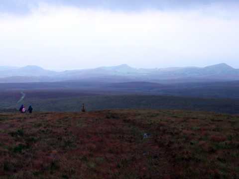
The day held little promise, with rain in the air, oppressive with humidity and the pungent smell of turf, as we set off up a track at A'n'col Ln (H13385 24714) 
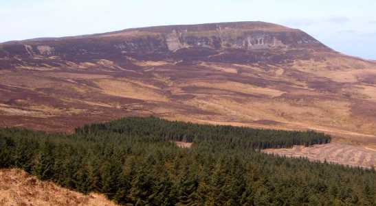
towards Benbeg. Three figures moved steadily out on the bog, hurriedly loading bags of peat into a tractor trailer, as we left the track for steep ground skirting the edge of forestry. Thick mats of sphagnum moss entangled with heather and bilberry made the going tough. Above the forestry we traversed the edge of a corrie with steep shaly slopes of honey coloured rock beneath Benbeg. The summit is unremarkable with no cairn, but the views compensate, especially the long sweeping ridge we were to cross, with Cuilcagh at the end, moody and shrouded in cloud.

Gaining the ridge involved traversing undulating boggy ground, picking a way through a maze of eroded peat hags, then a short scramble over gritstone outcrops. On the ridge the sun broke through the cloud with almost supernatural radiance, illuminating Cuilcagh’s trig point that protruded from its distinctive mound, resembling the breast of a slumbering mountain goddess. The wind driven mist billowed like smoke up over the sheer cliff edge. The rocky summit plateau is a delight. Outcrops of gritstone are weathered into intricate patterns, some slabs of it encrusted with quartz pebbles from an ancient deluge. Strange crevices, 20 ft deep that disappear, choked with glacial debris, before reappearing, harbour huge ferns.

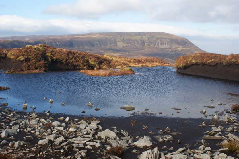
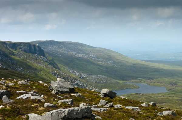
The cloud had now lifted, offering fine views of cornflower blue Lough Atona nestled at the foot of craggy cliffs set amid the russet and green of bog and heather. Towards the NE were small hills, ancient limestone reef knolls, and near pristine blanket bog with pools of water that sparkled merrily in the feeble sunlight.

To avoid the same return route, we scrambled down a steep cliff gully 
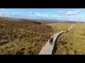
C (H11602 27151), heading across uneven boggy ground of reeds and knee high heather, jumping several small streams, for the edge of the forestry below Benbeg. At D (H12544 26110) we crossed a barbed wire fence by a tree stump, using forestry paths to return to our car, grateful for our 12 km odyssey through part of the North and South’s acclaimed Geopark. Linkback: mountainviews.ie/summit/165/comment/6447/
Read Less
Read More

            MountainViews.ie picture about Cuilcagh (<em>Binn Chuilceach</em>)
Picture: Cuilcagh from Benbeg
gerrym on Cuilcagh
by gerrym 1 May 2006
Climbed 5.6.04 starting at Cuilagh Mountain Park near to Marble Arch Caves ( Cuilcagh Boardwalk Trail (H121 336)). There is a large sink hole here but very difficult to see down into due to vegetation. Cross stile and follow track. Just after crossing bridge take "floating path" off to right, this soon ends but continue in westerly direction to pick up course of Sruh Croppa River after half hour. Follow winding course of river through gully with nice waterfall and past some ruined settlements. As near summit of Tiltinbane (596m) climb away from river to the right to avoid steep gullies. Follow fenceline up to the summit - the final section is quite steep and may require use of hands. A depression next to summit cairn is perfect shelter for a brew. There are extensive views from the summit ridge - north and west towards Sligo Bay and big hills which i think were the Nephin Beg Mountains in Mayo and south over Iron Mountains. Follow path which keeps close to northern cliffs, passing fissures in rock and Lough Atona ,reaching large summit cairn after 1.5 hour walk along summit.
Had intended to return by Ulster Way between Trien and Benaughlin (marker posts just visible) but shortened journey by heading north over moor following river courses back to the track at the bridge. A long walk at 6.5 hours but rewarding with plenty of interest and some good views.

The approach from the S via Benbeg is perhaps more rewarding - it cuts out a long approach through moorland and has a fine sweeping ridge with a very different perspective on the mountain (see Benbeg for this walk). Linkback: mountainviews.ie/summit/165/comment/995/
Read Less
Read More

Absalon on Cuilcagh
by Absalon 22 Oct 2002
One of the finest walks on Cuilcagh is from the townland of Eshveagh(E (H079 280)) to the Black Rocks(F (H140 239)). Map OSNI Sheet 26. Take the narrow straight road opposite (nearly) Glengevlin church. Half a mile on at a bend go through a gate on the R. Minutes later muddily ascend on the L into a field and veer to the R until you reach a barbed wire fence. Follow this until you reach a gate. Enter a narrow enclosure that has an earthen bank running along the centre. Follow the bank which will eventually bring you out on the heathery hillside where there is a primitive path that is difficult to find. However aim for the grassy ridges under the cliffs of Tiltinbane and when there,ascend steeply to the R or the L of the cliffs.There is a damaged megalithic tomb a little N of the highest point. A fine ridge stretches NE for 2-3 miles to Cuilcagh (or the Monument as it is locally known). Boggy ground is largely replaced by stony terrain with cliffs on the N side and limestone fissures on the ridge. From Cuilcagh descend SW to a boggy ridge,then veer S to Benbeg(539 on map). After Benbeg turn L rounding the cliff and descend with the forest on your L to a rough road which leads R to the main road R200 and the Black Rocks. Linkback: mountainviews.ie/summit/165/comment/172/
Read Less
Read More

            MountainViews.ie picture about Cuilcagh (<em>Binn Chuilceach</em>)
Picture: Wrapped in Blanket Bog
Bleck Cra on Cuilcagh
by Bleck Cra 1 Nov 2005
Cuilcagh is sulky. Set amid a demented geology of flint-hard upcrops and punctured limestone downdrops, it rides an undefined bog track between Fermanagh Lakeland and Free State moorland, middle-distant coastland and edgy Border badland. And the common denominator that binds all its diverse little bits is …… water; lots of it. In fact, I suspect all the seven seas of planet earth drain into Cuilcagh. Evidence? I was there on Saturday! Cra has been snared - by a Spartan Red Sock, one of the numerous upshots of which was to join this cheery troupe of sauntering track rats on their entirely unexplained outing to “Sulky”: unexplained that is, until we got dried out and into many hours of Halloween revelry in the Carry Bridge. Not built for speed - but these boys ARE built for stamina. Cuilcagh sloshes around on the Fermanagh Cavan border, Vistas to the western coast, south to The Iron Mountains and inland to more water are allegedly stunning. Sadly on this jaunt, all stunning was effected on bum bones when fleeing heels regularly brought bog and buttock into crunching contact. The track is so damp in places that the good people of some outdoor philanthropic persuasion have underlaid it with black plastic to give you some chance of progressing ahead rather than down. The thing about Cuilcagh bog is - it is an unique pristine blanket bog, uncut, untouched - made by nature, with springs meandering through it, ecosystems living in it, the Autumn remnants of fantastical flora soaking in it, a siren to bog-fanciers - and a must, to be continued in the heat and relative drouth of next summer. Follow your nose from Lisbellaw to Belcoo and pick up the Cuilcagh carpark enroute. Thanks to the Red Necks for a great day. Linkback: mountainviews.ie/summit/165/comment/2027/
Read Less
Read More

Mountain Walking Route (from Marble Arch) Closed
by murraynolan 1 Apr 2011
I am/was planning to walk Cuilcagh this weekend from the North via Marble Arch or Florence Court (9th/10th October 2010) however I just noticed this on the Marble Arch Caves website:

Published on:17 Sep 2010

Cuilcagh Mountain Walking Route Closed

Unfortunately due to a recent landslip, the walking trail to the summit of Cuilcagh Mountain at the end of the 4km vehicular gravel stone track within the Cuilcagh Mountain Park will be closed until further notice.

So, you (and I) may need to consider an alternative route. I have sought clarification and will update this comment if I hear more.

** UPDATE (1st April 2011 - no joke!) **
A visitor to my blog posted the following comment on my Cuilcagh piece.

"with talk of landslides and forestry work I asked WalkNI for their advice on a straightforward route to the top. Their advice was as follows:

The official answer is that the main route from the Marble Arch Geopark car park is still closed due to a landslide affecting a bridge, but it is known that people are still accessing the mountain from here by by-passing the bridge at their own risk. Another route that you could take would be from the Gortalughany Viewpoint carpark. Take the A32 south, ignore signs for Florencecourt and Marble Arch Caves, lookout for turn on Right signposted ‘Gortalughany viewpoint’. Follow this narrowing and steepening road to the car park at the top beyond a small, disused quarry.

From there, walk along the road then turn right towards the gate and follow this track in. Continue along the path to the limestone grassland at Leggacurragh, join the Hiker’s Trail by following the path to the west side of the valley, just by the information sign. Look for the waymarker post with Ulster Way signs and proceed from there! The last section of this route is very steep though so be prepared! Take an OSNI map too as when there is low cloud, waymarker posts cant be relied on due to low visiblity. Enjoy your walk!”
This is the map I’ll be using, the vieing point mentioned can be found in the South East of the Map:
http://www.walkni.com/d/walks/585/Cuilcagh%20Mountain.pdf

Thanks to "Trailtrekker" for the comment. Linkback: mountainviews.ie/summit/165/comment/6125/
Read Less
Read More
EDIT Point of Interest
text
Videos

Users Online

Guests online: 258
Recent Contributions
x
Conditions and Info
Use of MountainViews is governed by conditions and a privacy policy.
Read general information about the site.
Opinions in material here are not necessarily endorsed by MountainViews.
Hillwalking is a risk sport. Information in comments, walks, shared GPS tracks or about starting places may not be accurate for example as regards safety or access permission. You are responsible for your safety and your permission to walk.
See the credits and list definitions.

OSi logo
OSNI/LPS logo
Open Street Map
(Various variations used.)
British summit data courtesy:
Database of British & Irish Hills