This website uses cookies, which are small text files that the website puts on your device to facilitate operation. Cookies help us provide a better service to you. They are used to track general user traffic information and to help the website function properly.
Feature count in area: 62, by county: Cork: 45, Kerry: 24, of which 7 are in both Cork and Kerry,
OSI/LPS Maps: 78, 79, 85, 86, 88, 89
Highest Place: Knockboy 704.8m
Starting Places (47) in area West Cork Mountains: Barley Lake North, Barrboy, Caha Pass, Carranmore, Carrigacappeen, Carriganass Castle, Castle Donovan Car Park, Clearagh House, Coolkellure House, Coomhola Bridge, Corrigatirra, Cousane Gap, Cummer Lough East Road, Derreencollig Wood, Esk Boreen, Fuhiry Wood, Garinish Island Pier, Glasagarav River Bridge, Glasnacummeen Stream, Glengarriff, Glengarriff Nature Reserve CP, Gorteeniher Drimoleague Heritage Walk CP, Gortloughra River Road, Gougane Barra Oratory, Gougane Barra Park CP, Grousemount Wind Farm, Kealkill Village, Knockanuha, Knockbrack South, Lough Atooreen N, Lough Nambrackderg North, Lough Nambrackderg Wood, Lough Nambreacdearg, Mealagh Bridge, Molly Gallivan's Visitor Centre, Nowen Hill West Road, Owvane River Bridge, Pookeen North Top Road, Pooleen Wood Car Park, Priests Leap, Reenroe Bridge, River Roughty, Shandrum Concrete Silo, Sillahertane Stream, Slaheny River Horseshoe, Top of Coom, Turner's Rock Tunnel
Summits & other features in area West Cork Mountains: Cen: Maughanaclea: Maughanaclea Hills East Top 470m, Maughanaclea Hills West Top 452m Cen: Shehy More: Shehy More 545.6m, Shehy More SW Top 446m E: Clearagh: Clearagh Hill 287m E: Currane: Currane Hill 228m N Cen: Douce: Douce Mountain 476m, Doughill Mountain 471m N: Carran: Barnastooka 497m, Bealick 537m, Carran 604m, Carran Far NE Top 561m, Carran Far North Top 506m, Carran NE Top 555m, Carran South Top 567m, Knockantooreen 450m N: Conigar: Conigar 566m, Conigar SW Top 566m, Foilastookeen 540m N: Coomataggart: Carrigalougha 423m, Coomataggart 530m, Coomataggart SW Top 509m, Derrineanig 304m, Lackabaun 472m, Mweelin 487m NE Cen: Carrigarierk: Carrigarierk 343m NW: Barraboy: Barraboy Mountain 460m, Barraboy Mountain Far East Top 456m, Barraboy Mountain SE Top 409m, Derroograne 468m, Turners Rock 420m NW: Knockboy: Caoinkeen 692.8m, Caoinkeen South-East Top 553.5m, Coomhola Mountain 472m, Knockboy 704.8m, Knockboy North Top 651.2m, Knockboy South Top 533.3m, The Priest's Leap 519m NW: Knocknamanagh: Bird Hill 412m, Coomclogherane Top 449m, Gullaba Hill 603m, Knockbrack 440m, Knockbrack South Top 458m, Knocknamanagh 637m, Knocknamanagh NE Top 625m S Cen: Dunmanway Hills: Cashloura 296.8m, Coolsnaghtig 295.8m, Inchanadreen 310m S Cen: Nowen: Milane Hill 354.4m, Mullaghmesha 494.3m, Nowen Hill 535.2m, Nowen Hill Far West Top 405.2m, Nowen Hill SW Top 509m, Pookeen North Top 319m S: Leap Hills: Carrigfadda 311.7m, Killeigh Hill 229m, Knockarudane Hill 169m, Knockscagh 195m S: Skibbereen: Barryroe Hill 156m, Lick Hill 158m W Cen: Knockbreteen: Knockbreteen 239m W: Bantry: Knocknaveagh 282m
Note: this list of places may include island features such as summits, but not
islands as such.
Bealick, 537mMountain Béillic A name in Irish,
Place Rating ..
Ir. Béillic [OSi], ‘rock-shelter’, Cork/ Kerry County in Munster province, in Arderin Beg Lists, Béillic is the 455th highest place in Ireland.
Grid Reference W07073 66504,
OS 1:50k mapsheet 85 Place visited by: 69members, recently by: Grumbler, CusackMargaret, johncusack, a3642278, John.geary, childminder05, eiremountains, annem, dodser, jackos, hak493r, jlk, Colin Murphy, madfrankie, chelman7
I visited this place: NO (You need to be a logged-in member for this.)
Longitude: -9.34909, Latitude: 51.843582, Easting: 107073, Northing: 66504,
Prominence: 19m, Isolation: 1.7km ITM: 507043 566567 Bedrock type: Cross-bedded sandstone & siltstone, (Slaheny Sandstone Formation) Notes on name: The word béillic is used in West Cork and Kerry for a rock-shelter used by shepherds. This is often an overhanging rock or group of rocks which affords some cover from the elements. There is such a rock-shelter on the southern slopes of the mountain. The word may be a variant of speilg and sceilg, and all three may ultimately be derived from Latin spelunca, ‘cave’.
Short or GPS IDs, 6 char: Blck, 10 char: Bealick Linkback: https://mountainviews.ie/summit/1453/
Gallery for Bealick (Béillic) and surrounds
Summary
for Bealick (Béillic):
Small bump on a near level boggy ridge.
Summary created by simon3, millsd1
2018-08-06 10:18:25
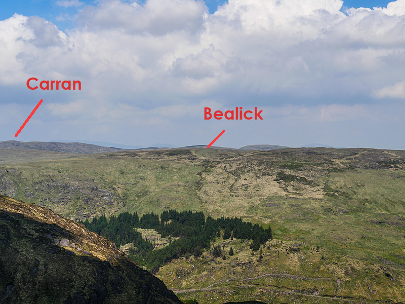
Picture: Unprominent Bealick in front of Carran
Gougane Barra access: Park in Gougane Barra at the western most carpark shown on OSI sheet 85 at grid ref A (W070 653).
Note there is a €5 all day parking charge, automated barrier, coins only accepted.
Follow the Gougane Barra Trail steeply uphill to the north from the car-park.
After about 600m the trail breaks clear of the forest and turns right. Stay on the trail to its high point about 80m further on.
You should then pick up a faint intermittent track heading north to the ridge.
Conditions underfoot are good on the track but expect long tussocky grass elsewhere.
There is no distinct summit. Best bet is to head for the fence T junction at B (W07077 66510) where you are within a stones throw of several likely contenders.
Approximately 1.7km, 270m ascent from carpark to summit taking about 45 mins one way.
(Carpark to Carran Far North return trip 6 hrs.).
Access from road at DernColg Wd (W052 650). This is also possible crossing rough but walkable land.
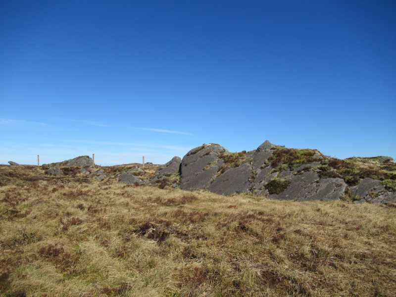
I approached this mountain from the North East ,coming from the Coomataggart mountains. When I got to the top I had to walk around for a few minutes to pinpoint the true summit; which I'm sure is the rocks in the photograph. Linkback: mountainviews.ie/summit/1453/comment/19904/
Read Less
Read More
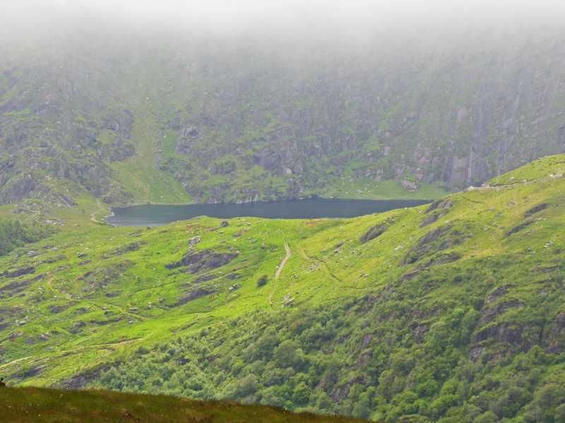
Picture: Lough Nambrackderg
Boring summit, beautiful area.
by Colin Murphy
30 Jun 2021
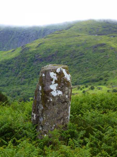
Like several of the hills in the area, Bealick is a summit barely discernible from the surrounding landscape, a slightly elevated boggy area that is unmarked. In compensation, there are decent views all round. As we descended to the SW we came across a fine example of a standing stone at roughly C (W053 652), along with fine views of Lough Nambrackderg nestling in the north eastern flank of Caoinkeen SE top. Linkback: mountainviews.ie/summit/1453/comment/23195/
Use of MountainViews is governed by conditions and a privacy policy.
Read general information about the site. Opinions in material here are not necessarily endorsed by MountainViews.
Hillwalking is a risk sport. Information in comments, walks, shared GPS tracks or about starting places may
not be accurate for example as regards safety or access permission. You are responsible for your safety and your permission to walk.
See the credits and list definitions.


 Our Facebook page.