Members and Supporters, the MountainViews Committee requests your help to meet the costs of the website and of other activities such as insured events or publications.
Feature count in area: 115, by county: Wicklow: 108, Kildare: 4, Wexford: 2, Carlow: 3, of which 1 is in both Wexford and Wicklow, of which 1 is in both Carlow and Wicklow,
OSI/LPS Maps: 28B, 55, 56, 61, 62, AWW, EW-DM, EW-LG, EW-WE, EW-WS
Highest Place: Lugnaquilla 924.7m
Starting Places (205) in area Wicklow: 1916 Memorial Car Park, Aghavannagh Ow Bridge, Aghowle Wood, Altidore Wood Entrance, Annacurra National School, Annalecka Bridge, Asbawn Brook L8350, Aughrim National School, Ballard Road, Ballinabarny Gap, Ballinagappoge Bridge Layby, Ballinagappoge Mountain Hairpin, Ballinagore, Ballinahinch Wood, Ballinastoe MBT CP, Ballinastraw South, Ballineddan Upr Fork, Ballinfoyle Upr Cross, Ballycoog, Ballycreen Brook Bridge, Ballycumber, Ballycumber Bridge, Ballycumber Lane, Ballycumber Wicklow Way, Ballylerane, Ballylow Bridge, Ballylusk Quarry, Ballymanus Lane, Ballymoyle Shooting Lodge, Ballynultagh Gap, Ballynultagh Lane, Ballyreagh Wood, Ballyross Forest, Ballysmuttan Long Stone, Baravore, Barnbawn South, Barranisky North, Barranisky West, Bohilla Land Roundabout, Bohilla Lane Mid, Boranaraltry Bridge, Bray Harbour, Brewel West, Brittas Bay North CP, Buckroney Sand Dunes CP, Bus Terminus, Camera Hill Track Cross, Castletimon Wood North, Clara Vale, Clone House Road, Clonegal, Cloon Wood Cp, Coate Bridge, Coolballintaggart Ledge, Coolbawn House Lane, Cransillagh Brook , Crone Wood CP, Crossbridge, Crossoona Rath, Cummer Wood South, Curtlestown Wood CP, Deputy's Pass CP, Derralossary Church, Derry River Bridge, Devil's Glen CP, Devil's Glen Wood, Djouce Wood Calary, Djouce Wood Lake, Djouce Wood Long Hill, Donard, Donnelly's Lane Car Sales, Drumgoff Forest, Dunranhill North, Dunranhill SE, Dunranhill South, Dwyer McAllister Cottage CP, Enniskerry, Fentons Pub, Fitzsimons Park GAA, unuseableFlemings Footbridge Glen Rd, Gap Pub, Gap Road, Glen Beach CP, Glen of the Downs CP, Glenbride Lane, Glenbride Lodge, Glencree Reconciliation, Glendalough, Glenealy GAA, Glenmacnass Tonelagee CP, Glenmalure Hostel, Glenmalure Lodge, Glenmalure Waterfall, Glenview Hotel, Gowle House, Great Sugar Loaf CP, Grove Bar, Heffernans Well Wood, Hill View, Hollywood Glen, JB Malone CP, Johnnie Fox Pub, Keadeen NE trail, Keadeen Trailhead, Kevins Way Footbridge, Kilbride Army Camp Entrance, Kilcandra South, Kilcommon View, Killalongford Wood, Kilmacrea Cross Roads, Kilranelagh House Gate, Kilruddery Car Park, Kilruddery Cottages, Kings River, Kippure Bridge, Kippure Estate, Kippure Transmitter Gate, Knickeen Cross, Knocknaboley Lane Leeraghs Bog, Knocknaboley Lane Stone Cottage, Knockrath Little, Knockree west, Kyle Loop North, Lackan Wood S, Lake Dr Fraughan Brook, Lake Drive, Lake Park Cross, Lake View Pub, Laragh Free Car Park, Laragh NSch, Lead Mines CP, Liffey Bridge, Liffey Head Bridge, Lough Bray Lower, Lough Bray Upper, Lough Tay North Viewing Point, Lough Tay Wicklow Way CP, Luglass Lane L97561, Lugnagun Track, Macreddin Village, Mangans Lane, Military Road Carrigshouk Hill, Military Road Inchavore River Nth, Military Road Inchavore River Sth, Military Road NW Lough Tay, Military Road Ballyboy Bridge, Military Road Cloghoge Brook, Military Road Croaghanmoira, Military Road Fananierin, Military Road LaraghWicklow Way, Military Road Slieve Maan, Monspolien Bridge, Moortown House, Mountain Rescue HQ, Muskeagh Little Wood, Nahanagan Lough NE, Novara Avenue, Bray, Oiltiagh Brook Knickeen, Old Bridge Cross, Old Bridge Scouts , Old Wicklow Way entrance, Paddock Hill SE, Pier Gates CP, Powerscourt Waterfall CP, Putland Road, Quintagh East, Raheen Park CP, Raheenleagh East, Railway Walk CP, Rathdrum Railway Station, Rednagh Wood, Rocky Valley, Roundwood, Sally Gap, Sally Gap N, Seefin Trailhead, Seskin SE, Shankill Tributary Bridge, Shay Elliott, Sheepshanks Bridge, Shillelagh, Slievecorragh Track, Slievefoore South, Sraghoe Brook, St John's Church, St Kevins Chair, St Kevins Church, St Kevins Way R756, Stone Circle Bridge, Stookeen South, Stranahely Wood, Stranakelly Cross Roads, Tallyho, Templeboden, Tithewer, Tomcoyle L, Tomriland Wood, Toor Brook, Trooperstown Hill Access, Turlough Hill CP, Upper Lake CP, Vallymount GAA CP, Vartry Reservoir Upper, Zellers Pub
Summits & other features in area Wicklow: Cen: Glendalough North: Brockagh Mountain 556.9m, Brockagh Mountain NW Top 549.5m, Brockagh Mountain SE Top 471.7m, Camaderry East Top 677.3m, Camaderry Mountain 698.6m, Conavalla 734m, Tomaneena 682.4m Cen: Glendalough South: Carriglineen Mountain 456.6m, Cullentragh Mountain 510m, Derrybawn Mountain 476.1m, Kirikee Mountain 474.5m, Lugduff 653.2m, Lugduff SE Top 638m, Mullacor 660.7m, Trooperstown Hill 430m N Cen: Tonelagee: Carrignagunneen 561m, Fair Mountain 571.2m, Stoney Top 713.7m, Tonelagee 815.8m, Tonelagee E Top 668m, Tonelagee South-East Top 545.8m NE: Bray & Kilmacanogue: Bray Head Hill 238.9m, Carrigoona Commons East 242m, Downs Hill 372.9m, Great Sugar Loaf 501.2m, Little Sugar Loaf 342.4m NE: Djouce: Djouce 725.5m, Knockree 342.1m, Maulin 570m, Tonduff 642m, Tonduff East Top 593m, War Hill 684.8m, White Hill 631.1m NE: Fancy: Ballinafunshoge 480m, Kanturk 527.4m, Knocknacloghoge 532.4m, Luggala 593.3m, Robber's Pass Hill 508.9m, Scarr 640m, Scarr North-West Top 559.8m, Sleamaine 430m NE: Vartry: Ballinacorbeg 336m, Ballycurry 301m, Dunranhill 342m, Mount Kennedy 365.9m NW: Blessington: Carrigleitrim 408m, Lugnagun 446.2m, Slieveroe 332m, Sorrel Hill 599.5m NW: Mullaghcleevaun: Black Hill 602.2m, Carrigshouk 572.5m, Carrigvore 682.4m, Duff Hill 720.8m, Gravale 719m, Moanbane 703m, Mullaghcleevaun 846.7m, Mullaghcleevaun East Top 796m, Silsean 698m S: Aughrim Hills: Cushbawn 400m, Killeagh 249m, Moneyteige North 427m, Preban Hill 389m S: Croaghanmoira: Ballinacor Mountain 529.3m, Ballycurragh Hill 536m, Ballyteige 447m, Carrickashane Mountain 508m, Croaghanmoira 662.3m, Croaghanmoira North Top 579.5m, Fananierin 426m, Slieve Maan 547.8m, Slieve Maan North Top 546.1m S: Croghan Kinsella: Annagh Hill 454m, Croghan Kinsella 606m, Croghan Kinsella East Top 562.1m, Slievefoore 414m S: Shillelagh Hills: Lakeen 357m, Monaughrim 206m, Seskin 344m, Stookeen 420m S: Tinahely Hills: Ballycumber Hill 429.7m, Eagle Hill 296m, Muskeagh Hill 398.2m SE: Wicklow South East: Ballinastraw 284m, Ballyguile Hill 188m, Barranisky 280m, Carrick Mountain 381m, Collon Hill 238m, Kilnamanagh Hill 217m, Westaston Hill 270m W: Baltinglass: Ballyhook Hill 288m, Baltinglass Hill 382m, Carrig Mountain 571m, Carrigeen Hill 298m, Cloghnagaune 385m, Corballis Hill 258m, Keadeen Mountain 653m, Spinans Hill 409m, Spinans Hill SE Top 400m, Tinoran Hill 312m W: Cen Lugnaquilla: Ballineddan Mountain 652.3m, Benleagh 689m, Camenabologue 758m, Camenabologue SE Top 663m, Cloghernagh 800m, Corrigasleggaun 794.6m, Lugnaquilla 924.7m, Slievemaan 759.7m W: Donard: Brewel Hill 222m, Church Mountain 544m, Corriebracks 531m, Lobawn 636m, Slievecorragh 418m, Sugarloaf 552m, Table Mountain 701.7m, Table Mountain West Top 563m
Note: this list of places may include island features such as summits, but not
islands as such.
Lugnaquilla, 924.7mMountain Log na Coille A name in Irish,
Place Rating ..
(Ir. Log na Coille [IPN], 'hollow of the wood'), Lugnaculliagh County Highpoint of Wicklow in Leinster province, in County Highpoint, Arderin, Vandeleur-Lynam, Irish Highest Hundred, Irish 900s Lists, Lugnaquilla is the highest mountain in the Wicklow area and the 12th highest in Ireland. Lugnaquilla is the highest point in county Wicklow.
Grid Reference T03209 91777,
OS 1:50k mapsheet 56 Place visited by: 1855members, recently by: kieran117, David.Smyth, rhw, jollyrog, purpleknight, KateLeckie, MartMc, Courin, MeabhTiernan, discovering_dann, AnnaJ, orlaithfitz, maoris, davidrenshaw, Lidia27
I visited this place: NO (You need to be a logged-in member for this.)
Longitude: -6.464643, Latitude: 52.967149, Easting: 303209, Northing: 191777,
Prominence: 905m, Isolation: 1.7km, Has trig pillar
ITM: 703135 691812 Bedrock type: Aphyric granodiorite, (Percys Table Granodiorite) Notes on name: Presumably the name is transferred from some nearby hollow to the mountain itself. Price has a useful note to this effect, but is unable to determine the hollow in question. There are three valleys in the vicinity: Fraughan Rock Glen to the north-east, the South Prison to the south-east and the North Prison to the north-west. The first two are both forested nowadays. The summit is marked as Percy's Table, named after a local landowner of the 18th century. Cf. Dawson's Table on Galtymore. P.W. Joyce gave the original form as Log na Coilleach, 'hollow of the (grouse) cocks'. However this seems doubtful. It does not show the urú which would be expected. Nor is the name connected with the deity Lug.
Short or GPS IDs, 6 char: Lgnql, 10 char: Lugnaquila Linkback: https://mountainviews.ie/summit/13/
Gallery for Lugnaquilla (Log na Coille) and surrounds
Summary
for Lugnaquilla (Log na Coille):
A bulky mountain with many routes and long range views but hazards abound.
Summary created by markmjcampion, simon3, kernowclimber, Peter Walker
2023-08-16 16:29:36
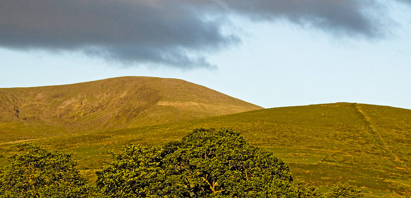
Picture: Lugnaquilla from the West, Camarahill to right.
Lug as it is popularly known is Ireland's highest pt outside Kerry. The large summit cairn and trig pillar sit on a fairly flat dryish top with views better distant than near (mainly of the rest of Wicklow and Mt. Leinster), often surrounded by people and sadly, litter. There are several ways up and some serious hazards esp in bad weather so map, navigational gear and skill are essential.
NE. Park at Baravore at around B'vore (T06625 94175). Here you have options : straight up the Fraughan Rock Glen[aim for A (T03100 93341) and swing S ], via Camenabologue along the Stony Road[aim for B (T02078 96712)], or via Arts Lough[head for lake at C (T05769 93872)] and Cloghernagh.
WNW. The shortest route starts at CamHill X (S98419 92917) reached on a rough road from near Fenton’s Pub. Go up the track to Camarahill and do not deviate because the surrounds are regularly used as an artillery range, well marked on maps – route sometimes closed.
S. Park at Aughavannagh Bridge Aghav Brg (T05591 86108). Follow the Ow valley to D (T03835 91979) and on to the summit with variations on the W and E ridges.
There are also routes via Carrawaystick Mt, Ballineddan Mt and some gullies.
Hard to find summit in low cloud. Without good navigation there is a risk of descending accidentally onto any of the 3 severe slopes, of which two are marked on maps as the North Prison, the South Prison and the unnamed NE facing slope or into the artillery range.
Notable tracks incl track/1236, track/4508, track/2292 and track/2059.
Sunday 19/12/2021 was a strange day for weather. To be able to see Wales from the top of Lug was surreal. I spoke to some locals from Donard in Fenton's in the Glen of Imaal and they told me they'd been climbing up regularly all their lives and never witnessed it.
The direction finder on the summit told me I was also seeing the Galtees and Keeper Hill to the west.
As I headed off I met some people who asked me about a pointy hill to the south east. It was one I couldn't identify. Mountainviews has confirmed it was Slieveboy in North Wexford. Linkback: mountainviews.ie/summit/13/comment/23367/
Read Less
Read More
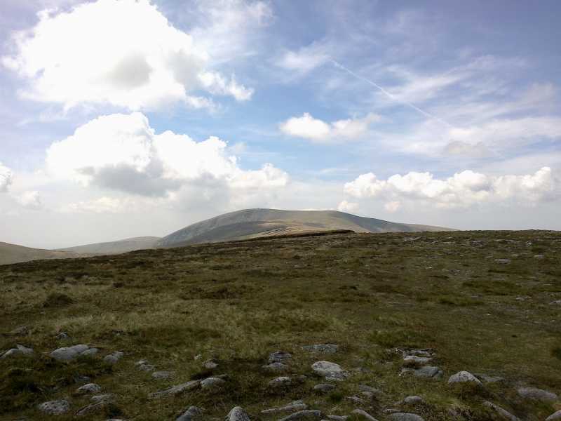
Picture: Lug from the top of Cloghernagh
Lug from Glenmalure side
by Sarkuns
11 Jun 2013
I climbed Lug from Glenmalure side. I start at bridge which crosses the Avonbeg River at the base of the Zigzags. Please use the gates and the marks to guide you… the zigzags are in very good condition. It was used as hunting trail long time ago but now they are renewed and still in use by the local farmers. As the path is still in use and it goes through sheep grazing grounds remember to leave your dogs at home and try not to scare the sheep’s. At the top of the zigzags there are a boggy trails, all of them will lead you to the fence but only one to the stairs over the fence. Please use the stairs and do not damage the fence.
When you find the stairs it is pretty straight forward. Keep on the path and everything should be ok. The path which is leading on the top of the Cloghernagh is weary easy to see. On the bad weather it is possible that it is muddy but I had the luxury of a good weather and excellent visibility.
From Cloghernagh to Lug the trail is harder to see but in good weather you just take the Lug as your target and go for it… Just be careful on your way back because there are no landmarks to follow so GPS or a map could be vital. I find my bearings using the surrounding mountain peaks.
Be careful there on bad weather. The rocky path is tricky and on some places there are holes on the path which will swallow your leg or ankle…
While I was in the middle of Cloghernegh I almost step on the hare. He jumped away but I was completely surprised. I have seen a lot of them near the Lought Dan but not so close. Linkback: mountainviews.ie/summit/13/comment/15018/
Read Less
Read More
No parking at Aughavannagh Bridge - Ow river route up Lugnaquilla
by GerryCarroll
19 Jul 2022
Having climbed Lugnaquilla many times over the years via all regular routes with the exception of the Ow River/valley at Aughavannagh Bridge, I decided it was time to have a go at this route. On Friday 15th July 2022 I drove to the starting point at Aughavannagh Bridge Aghav Brg (T056 861).
The access point to this hike is via a standard Coillte gate. There is no parking at or near this gate as the entrance is not wide enough to allow a car to park and for a truck or car to pass to access the Coillte land and the signage erected by Coillte makes this very clear.
I drove for approx. 1500 meters in both directions from the bridge to see if there was anywhere else to park but there aren't any suitable parking spots. Most of the houses/farms nearby have NO PARKING signs erected on their gates/fences which leads me to believe that the locals must have had some bad experiences with people parking in and around this area.
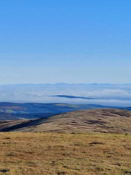
Picture: On route to Lugnaquilla looking back towards Glenmalure Valley
from Glenmalure
by paddyobpc
23 Jan 2017
Walk Date: 23 Jul 2015. I had walked Lugnaquilla previously in 2011 from near the Glenmalure Hostel returning into the Glenmalure valley via the zig zags and walking the road back up to the car. This time we were staying nearby for a few nights and my daughter Rachel and son Dillon(dillonkdy) joined me on the climb. We climbed the same route as previously but this time returned the same way due to it getting a bit close to evening. It was a nice evening for the walk with good enough visibility and views. This time we were on the mountains for about 4.5 hrs covering over 14 Km climbing a height of 800m. See Dillon’s (dillonkdy) full story of his County High Point Challenge at https://dillons32chpchallenge.github.io/progress/index.html We also found Kieron Gribbon's High Point Ireland website (www.highpointireland.com) to be a useful source of information for our 32 County High Points challenge. Definitely worth checking out if you're planning to do any of the High Point challenges. Linkback: mountainviews.ie/summit/13/comment/18803/
Read Less
Read More
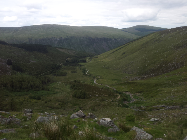
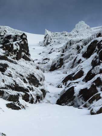
Picture: North Prison Gully
Winter Climb of North Prison's Main Gully
by kernowclimber
7 Apr 2010
The sight of the Great Sugar Loaf wearing a faint snowy hat and the desire to escape the ennui of the office convinced us to take to the hills! Discovering that the Army wasn’t using the artillery range, we resolved to make climbing the main gully on Lugnaquillia’s North Prison our objective for the day.
We parked at the first gateway to the artillery range up the rough track past Fenton’s Pub and began the long pull up Camarahill savouring the crunch and squeak of fresh snow beneath our boots. We descended the steep side of Camarahill towards the Bluffs rising steadily to gain the corrie beneath Lugnaquillia’s North Prison. Once off Camarahill the sun was surprisingly hot but the weather was fickle; kaleidoscopic clouds raced across a Prussian blue sky, occasionally grey and angry enough to generate flurries of snow. Huge granite boulders encrusted with ice lay amid drifts of snow feet thick on the outstretched arm of terminal moraine that seemed to gently coax us upwards and inwards to the corrie. Obstacles such as secret streams obscured beneath a blanket of glittering snow betrayed only by their musical tinkling, and patches of bog unseen until trodden on, slowed our pace considerably.
We located the main gully (E (T028 920)) at the back of the corrie, a white streak shooting some 200 metres upwards towards the summit. It didn’t look all that steep before we began to climb it, but appearances are deceptive. This is described as a Scot Grade I climb in the Wicklow climbing guide, but in places the slope surpasses 45 degrees and the fact that a fresh covering of snow lay atop granular, in places very unstable old snow and compacted ice, made progress difficult. Mcrtchly had to cut steps for almost the entire route and I would estimate the route in this condition was verging on a Scot Grade II endeavour. The crux of the route lay only 10 metres or so from the bottom where sheets of ice had consolidated over boulders making the use of the pick end of an ice axe essential to maintain upwards progress.
The view up the gully was superb. On the right, about half way up is a very distinctive pyramidal pinnacle of rock that was picked out sharply against a deep blue sky, making the surroundings appear and feel positively Alpine. Every so often chunks of ice and snow fell from the surrounding walls with a dull thud followed by a strident hiss as thousands of small chunks sped off down the gully.
By the time we exited the gully, cloud had enveloped the summit and we did not tarry there long as an icy wind beckoned a change in the weather. We descended rapidly in our crampons towards Camarahill surprised to see how quickly the snow had melted. Some 12kms and 8 hours later we were walking towards the warm, inviting glow of the window of Fenton’s Pub, drawn there by the cheerful sound of a jaunty Irish jig filling the quiet night and the knowledge that a glass of Guinness awaited us to celebrate our day out on Wicklow’s highest peak. Linkback: mountainviews.ie/summit/13/comment/4574/
Use of MountainViews is governed by conditions and a privacy policy.
Read general information about the site. Opinions in material here are not necessarily endorsed by MountainViews.
Hillwalking is a risk sport. Information in comments, walks, shared GPS tracks or about starting places may
not be accurate for example as regards safety or access permission. You are responsible for your safety and your permission to walk.
See the credits and list definitions.


 Our Facebook page.