Members and Supporters, the MountainViews Committee requests your help to meet the costs of the website and of other activities such as insured events or publications.
Feature count in area: 45, all in Donegal,
OSI/LPS Maps: 11, 6
Highest Place: Croaghgorm 674m
Starting Places (22) in area Bluestack Mountains: An Leathchruach, Barnsmore Gap, Bensons Hill, Caldragh CP, Clogher South peak, Cruach Mhín an Neanta, Doobin, Eanybeg Water Bridge, Edergole Farm, Gaugin Mountain, Glennacree CP, Hillhead, Lough Finn West, Lough Magrath Beg NE, Lough Muck North, Meenaguse Lough, Sand Lough Forest Picnic Area, Scoil Náisúnta an Choimín, Sheskinlubanagh, Sruell Gap Farm, Sruell River Road, St Columbkilles Well and Altar
Summits & other features in area Bluestack Mountains: Cen: Reelan Hills: Altnapaste 364m, Gaugin Mountain 565m, Lacroagh 403m, Boultypatrick 429m, Croveenananta 476m, Croaghubbrid 416m, Croaghugagh 410m N: Fintown Hills: Aghla Mountain South Top 589m, Aghla Mountain 593m, Scraigs 426m, Croaghleheen 385m NW: Glenties: Cloghercor South 301m, Derkbeg Hill 332m, Drumnalough Hill 282m S: Belshade: Croaghgorm 674m, Croaghgorm South-West Top 597m, Croaghgorm East Top 594m, Ardnageer 642m, Ardnageer SW Top 626m, Banagher Hill 392m, Croaghbane 641m, Croaghgorm Far South-West Top 561m, Cronamuck 444m, Croaghbarnes 498.8m, Glascarns Hill 578.3m, Meenanea 435m SE: Barnesmore: Brown's Hill 496.4m, Cloghervaddy 402m, Croaghagranagh 440m, Croaghanirwore 546.1m, Croaghbrack 401m, Croaghconnellagh 523m, Croaghnageer 569.1m, Croaghnageer East Top 543.5m, Croaghnageer North-East Top 521m, Croaghonagh 451m SW: Eany Beg Hills: Binbane 453m, Binbane NE Top 439m, Lavagh Beg 650m, Lavagh More 671m, Binnasruell 505m, Carnaween 521m, Cloghmeen Hill 429m, Silver Hill 600m, Cullaghacro 476m
Note: this list of places may include island features such as summits, but not
islands as such.
Cronamuck, 444mHill Cruach na mBoc A name in Irish,
Place Rating ..
Ir. Cró na mBoc [logainm.ie], 'hollow of the bucks’, Donegal County in Ulster province, in Carn Lists, Cronamuck is the 755th highest place in Ireland.
Grid Reference H01153 91858,
OS 1:50k mapsheet 11 Place visited by: 18members, recently by: abeach, madfrankie, Colin Murphy, eamonoc, gerrym, melohara, noucamp, johncromie, Aidy, Fergalh, mark-rdc, Garmin, osullivanm, simon3, Brambler
I visited this place: NO (You need to be a logged-in member for this.)
Longitude: -7.982867, Latitude: 54.774615, Easting: 201153, Northing: 391858,
Prominence: 89m, Isolation: 0.7km ITM: 601102 891848 Bedrock type: Main granite (adamellite), (Barnesmore Granite, G2 variety) Notes on name: This is one of a number of Donegal hill names in which the element cró (which normally means 'a hollow' or 'a sheep-pen') has apparently become confused with cruach ('stack').
Short or GPS IDs, 6 char: Crnmck, 10 char: Cronamuck Linkback: https://mountainviews.ie/summit/638/
Gallery for Cronamuck (Cruach na mBoc) and surrounds
Summary
for Cronamuck (Cruach na mBoc):
Granite knob at the end of a ridge.
Summary created by simon3
2013-05-20 19:54:43
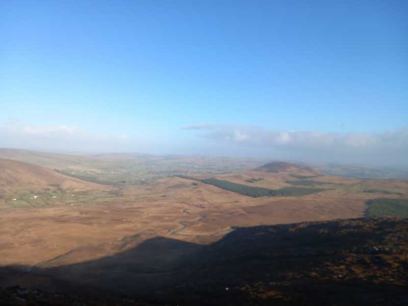
Picture: Cronamuck, showing its steep west flank.
This summit can be reached using the ridge extending NE from Croaghbarnes and there are suggestions it could be reached from Commeen to the north on the R253.
Cronamuck has views over towards Gaugin Mountain, Croaghbane and the magnificent but unfrequented Owendoo River valley.
Underfoot Cronamuck and nearby is made of often bare worn granite. The summit appears to be an unattached boulder of perhaps a metre in height.
A potential hazard is that on its west, north and east there are small rivers that could become impassable at short notice in wet weather.
Picture: Looking towards Croaghbane from Cronamuck
Start of a brilliant ridge leading to the Bluestacks
by gerrym
21 Sep 2020
Started at the Old School House in the Reelan River Valley and followed the Sli na Finne over open hillside, forest track and a quiet country lane. This was some 10km away from the summit, though it made sense for the circuit I had planned, accessing the main Bluestacks via the ridge starting with Cronamuck. Stopped for a good chat with a women hanging out her washing who knew the names of the hills I was about to climb much better than me :-)
Followed a track off the road at A (H0118 9424) which crossed the Owengarve River. This went past a house where I was prepared to ask permission though didn't see anyone. I had to open/close a couple of gates after the house on an old bog track. A further river crossing of the Owendoo River is required, though without the aid of a bridge this time. It was fairly easy for me to cross and I would expect this to be much more difficult after wet weather.
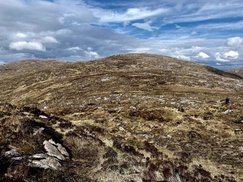
It was a good climb up Cronamuck, though nowhere near as steep as its distant profile had suggested. The views up the Owendoo River Valley were stunning and with height the corrie lough of Cronloughan, nestled below Glascarns Hill became visible. With height the grass satisfyingly gave way increasingly to rock- as with many of the hills in the Bluestacks.
There are a number of little tops on the summit and the area is well worth exploring for the outstanding views in all directions. There is also a beautiful little lough that is well worth visiting to gather breath or some water. A great ridge walk was laid out before me to Croaghbarnes and then on to the main Bluestacks. This was a great alternative to my traditional route up Glacarns Hill, though did clock up quite a few extra km :-) Linkback: mountainviews.ie/summit/638/comment/20898/
Read Less
Read More
Picture: South over Meenanea, Croaghanirwore & Croaghnageer
Exhausting, But Worth It
by Aidy
13 Apr 2015
Cronamuck was my third peak of this walk, having started north of Lough Eske, and already taken in Croaghbarnes and Meenanea. I am constantly amazed at the length of some of the walks undertaken by members here, but I can only judge my efforts by my own standards, and I found this walk very tiring over difficult ground. But, the stage from Meenanea to Cronamuck was probably the easiest part of the walk, and the extra distance was so short, it would have been inconceivable not to do it. Especially since I'd failed to reach Cronamuck on a previous attempt from the north. As Simon had predicted in his Short Summary, the rivers on that approach had proved impassable after a period of heavy rains. Those same rivers now viewed from the summit, provided some of the best views, along with the many other surrounding peaks. It had been a thoroughly enjoyable walk, but it was hard going on the way back. I avoided the ascent and descent of Croaghbarnes on the return leg, staying on low ground on its southern side, but this was probably equally hard - boggy, with tussocky grass. As usual, when I got back to the car, I was exhausted but very happy. Linkback: mountainviews.ie/summit/638/comment/17929/
Walked from Barnesmore Gap to Commeen and Cronamuck. The views from the summit are superb and climbing the mountain from the Commeen side would be straightforward. As a child I used to think Cronamuck looked an Irish Ayers Rock! Linkback: mountainviews.ie/summit/638/comment/3176/
Read Less
Read More
Picture: Cronamuck (left) and Meenanea (right)
As tough as they come.
by Colin Murphy
8 May 2023
As tough a Carn as possible given its relative remoteness. Our journey from the SW was an exhausting 17km and over 7 hours (see track 4871). The shot shows Cronamuck on the left and Meenanea on the right taken from the Croaghbarnes ridge. Linkback: mountainviews.ie/summit/638/comment/23943/
Use of MountainViews is governed by conditions and a privacy policy.
Read general information about the site. Opinions in material here are not necessarily endorsed by MountainViews.
Hillwalking is a risk sport. Information in comments, walks, shared GPS tracks or about starting places may
not be accurate for example as regards safety or access permission. You are responsible for your safety and your permission to walk.
See the credits and list definitions.


 Our Facebook page.