Members and Supporters, the MountainViews Committee requests your help to meet the costs of the website and of other activities such as insured events or publications.
Feature count in area: 58, all in Down,
OSI/LPS Maps: 20, 29, EW-CLY
Highest Place: Slieve Donard 849m
Starting Places (33) in area Mourne Mountains: Alex Steddom Tree, Aughrim Airstrip, Ben Crom Dam, Bloody Bridge Car Park, Carlingford Greenway, Carrick Little, Crocknafeola Wood, Crotlieve Mountain, Donard Car Park Newcastle, Drummanmore Picnic, Fofanny Reservoir, Forest Office CP, Gamekeepers Lodge CP, Happy Valley Trassey Rd, Hen Mountain CP, Leitrim Lodge CP, Mayo Road Corner, Meelmore Lodge, Newcastle Harbour, Ott CP, Red Bog Road, Rourkes Park, Sandy Brae, Silent Valley Reservoir Head Rd, Slieve Donard Trail Head, Slieve Foye Viewing Point, Slievefoy Forest CP, Spelga Dam E, Spelga Dam N, Spelga Dam S, Trassey Car Park, Two Mile River CP, Yellow Water Park
Summits & other features in area Mourne Mountains: Cen: Loughshannagh: Ben Crom 526m, Carn Mountain 585.2m, Carn Mountain North Top 553.7m, Doan 592.6m, Ott Mountain 526.8m, Slieve Loughshannagh 617m, Slieve Muck 670.4m, Slievenaglogh 445m E: Binnian: Slieve Binnian 745.9m, Slieve Binnian East Top 639m, Slieve Binnian North Top 678m, Slieve Binnian North Tor 682.5m, Wee Binnian 460m E: Donard: Chimney Rock Mountain 656m, Crossone 540m, Millstone Mountain 460m, Rocky Mountain 524m, Slieve Donard 849m E: Lamagan: Cove Mountain 654.8m, Slieve Beg 595.9m, Slievelamagan 702.2m N: Bearnagh: Slieve Bearnagh 739m, Slieve Bearnagh North Tor 680m, Slieve Meelbeg 701.9m, Slieve Meelmore 687m N: Castlewellan: Slievenalargy 280m, Slievenaslat 272m N: Commedagh: Slieve Commedagh 767m, Slieve Corragh 641.9m, Slievenaglogh 584.4m, Slievenaglogh East Top 571m N: Croob: Cratlieve 429m, Slieve Croob 534m, Slievegarran 391m, Slievenisky 446m N: Rathfriland: Knockiveagh 235m S: Kilkeel: Knockchree 306m S: Rostrevor: Crenville 460m, Finlieve 578m, Slievemartin 485m, Slievemeel 420m, Slievemeen 472m W: Hilltown: Gruggandoo 382m, Slieveacarnane 296m W: Slievemoughanmore: Crotlieve Mountain 347m, Eagle Mountain 638m, Rocky Mountain 404m, Shanlieve 626m, Slievemoughanmore 560m, Tievedockaragh 473m, Wee Slievemoughan 428m W: Spelga: Butter Mountain 500m, Cock Mountain 504m, Cock Mountain South-West Top 505m, Hen Mountain 354m, Pigeon Rock Mountain 534m, Pigeon Rock Mountain South Top 530m, Slievenamiskan 444m
Note: this list of places may include island features such as summits, but not
islands as such.
Slieve Donard, 849mMountain Sliabh Dónairt A name in Irish,
Place Rating ..
(Ir. Sliabh Dónairt [PNNI], 'mountain of (St.) Domhangart') County Highpoint of Down in Ulster province, in County Highpoint, Arderin, Vandeleur-Lynam, Irish Highest Hundred Lists, Slieve Donard is the highest mountain in the Mourne Mountains area and the 19th highest in Ireland. Slieve Donard is the highest point in county Down.
Grid Reference J35796 27690,
OS 1:50k mapsheet 29 Place visited by: 1516members, recently by: kieran117, Henning86, rhw, purpleknight, MeabhTiernan, westside, cclair, Deirdreb, discovering_dann, orlaithfitz, davidrenshaw, Lidia27, Magic, Prem, sprog
I visited this place: NO (You need to be a logged-in member for this.)
Longitude: -5.920976, Latitude: 54.180221, Easting: 335796, Northing: 327690,
Prominence: 821m, Isolation: 1km, Has trig pillar
ITM: 735710 827693 Bedrock type: Granite granophyre, (Mourne Mountains granite) Notes on name: Slieve Donard is the highest mountain in Northern Ireland and in 9-county Ulster. St. Domhangart (modern form Dónart), a contemporary of St. Patrick, founded a monastery at Maghera north of Newcastle. According to tradition he was appointed by St. Patrick to guard the surrounding countryside from the summit of Slieve Donard. He is supposed not to have died, but to be a 'perpetual guardian' (see MacNeill, 84-96). In pagan times this mountain was known as Sliabh Slainge. Slainge, the son of Partholon, was the first physician in Ireland. According to the Annals of the Four Masters, he died in Anno Mundi 2533 (2533 years after the creation of the world according to Irish mythology) and was buried here in a cairn. On the top of Slieve Donard there are two cairns, one on the very summit and the other, called the 'Lesser Cairn', on the Ordnance Survey maps, some eight hundred feet to the north-east. Both of them have been much disturbed. The Summit Cairn has been tampered with by sappers and water commissioners: the Lesser cairn has small piles of stones about it, but it is difficult to say whether these are ancient structures or just re-arrangements by modern hands. Dr. Estyn Evans, who calls the Summit Cairn 'the oldest mark of man in the Mournes', says that it is a 'corbelled passage grave of the early Bronze Age.' The Lesser Cairn, he points out, is visible from the sandhills of the shore, although the Summit Cairn is not (MacNeill, 85).
Short or GPS IDs, 6 char: SlvDnr, 10 char: SlvDnrd Linkback: https://mountainviews.ie/summit/19/
Gallery for Slieve Donard (Sliabh Dónairt) and surrounds
Summary
for Slieve Donard (Sliabh Dónairt):
Ulster’s highest – a boggy, well-trodden, rounded seaside peak.
Summary created by markmjcampion, Harry Goodman
2023-08-16 16:35:26
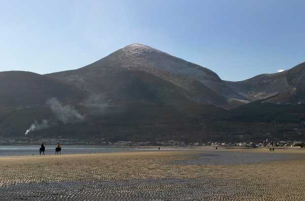
Picture: Slieve Donard from Newcastle Beach
Slieve Donard on the eastern edge of the Mournes is a peaty mound topped off by a rocky crest. The 35k Mourne Wall passes over the summit. Fine views in most directions incl. the Coolies, Sperrins and Antrim Hills. In very clear conditions the Galloway Hills, Isle of Man and the Wicklow Mts are visible.
NE. From Donard Park DonCPNc (J37499 30597) head SW through Donard Wood up the Glen River track, then out across open ground and a steep climb up to the Mourne Wall A (J35021 27934). Go left steeply up stone steps to the top. Alternatively, once on open ground DonTrHd (J36405 29590) go S down across the river and then up the Black Stairs, a short steep rocky climb alongside a stream which soon gives way to a gentler slope of grass/heather. At B (J36501 28591) swing SW and continue up over steeper rocky ground to the Lesser Cairn and walk up and across to the Great Cairn and the top. Either route should have you at the top in 2.5 hrs.
E. Start at Bloody Bridge Car Park Blood Br (J38886 27108). Go S along the road for 150m and turn right on to a track following the Bloody Bridge River up to the Mourne Wall and turn right to follow the wall to the summit. [less than 2hrs to summit]
S. Longer approaches are possible from the carpark at Carrick (J34497 21914) by first taking in Rocky Mt. and/or Chimney Rock.
Donard is also part of the Mournes’ Sevens which takes in the 7 highest peaks in the range over 29km.
Notable tracks include the linear track/3350 and track/3379 and the long track/3423.
My very first trip to the Mournes was in March’07. Not only was I intending to climb Donard but I really wanted to see the infamous Mourne Wall too. I left Dublin early and eventually found my way to Donard Park carpark in Newcastle at approx C (J376 307).
I followed the track from the carpark up along the Glen River. It was a nice walk which got me warmed up on that very cold day. Following the track brought me to a useful information board at approx D (J366 297), which described a curious Ice House situated further along the track across the river. The track then led past this Ice House and into the valley below Donard and Commedagh. Being my first trip to the Mournes I was surprised at how easy this navigation was-far different from staring across featureless bog in deepest Wicklow! Just following this clear track was going to bring me from the carpark right up to the col below Donard!
The stone track brought me to the top of the valley, across a stream and headed up to the col in a series of steps. It had been getting progressively colder and extra layers were needed. Also snow lay on the valley slopes. I discovered that the track up to the col was covered in ice in many places and impossible to walk on. I scrambled up beside it but it was difficult and I needed my wits about me. I had seen the Mourne Wall from below but it disappeared from view as I climbed. I was thrilled when I eventually reached it. To seasoned Mourne walkers the Wall is an everyday thing that is probably invisible to them, but to me it was the Thing of Legend. I admired the breathtaking views from the Wall across the Mournes. A fantastic stile allowed an easy climb over the Wall. I couldn’t name any of the unfamiliar summits. It was too cold to take out the map and snow lay all across the hills.
I then turned left to begin the trek up along the Wall to the summit of Donard. I had never seen such a steep climb, and snow lay in deep drifts to further test my will.
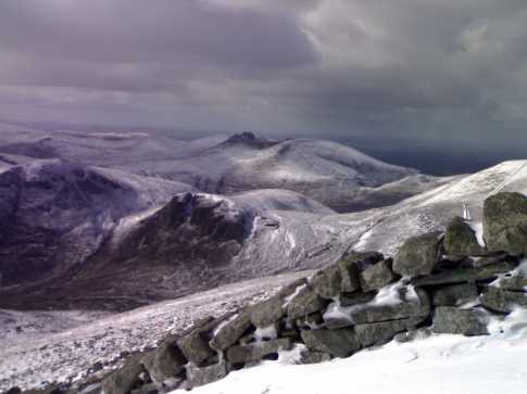
The details of that tortuous and soul-sapping climb would require a book in itself but suffice to say I made it. The accompanying photo shows the majesty of the snow-covered view from Donard that day. I was really getting a baptism of fire!
My plan to retrace my steps was out of the question due to the lethal ice-covered track below the col so I headed South along the Wall to find the route to Bloody Bridge. The snow was 3 feet deep in places on this side and another survival adventure ensued. I followed the Wall to approx E (J353 268) and turned left. Eventually I reached the Bloody Bridge and a Bloody Long Walk back to Newcastle and my car. An excellent day and an excellent introduction to the Mournes! Linkback: mountainviews.ie/summit/19/comment/3244/
Read Less
Read More
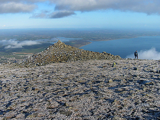
Picture: Looking NE across Donard Lesser Cairn
Harry Goodman on Slieve Donard
by Harry Goodman
29 Sep 2009
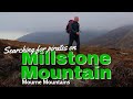
For anyone looking for a different approach to Slieve Donard I would recommend a route starting at the Harbour in Newcastle F (J381 296) which initially follows the waymarked Granite Trail steeply up the line of a former funicular railway known locally as the Bogey Line. After crossing the stile at the top end of the trail the track turns right to cross another stile and then the high point of the Granite Trail. From G (J371 293) climb up around the right side of the quarry near by making sure to stay well away from the edge on your left hand side. Gradually work your way round by heading SW and then SE across a sream and up to the top of Millstone Mountain at H (J373 285). Walk SW across a boggy coll before starting to climb up the eastern slopes of Slieve Donard. Initially the terrain is soft and peat covered but soon changes to rockey ground leading up to the Lesser Cairn at I (J35950 27900). From here it is a short gentle walk up to the the highest point in Ulster. Descend W with a touch of N along the Mourne Wall to pick up a paved stoney track down to the coll J (J24950 27950) and then NE down the Glen River Track ( the most frequently used route up and down the mountain ). On the way down the restored Ice House on the other bank of the river is worth a look at approximately K (J364 295). Continue to follow the river track down to Donard Bridge L (J372 302). Do not go across but rather turn right and follow the forest track out to the public road and then left to the main Newcastle to Kilkeel road. Turn right and walk along to the Harbour car park. Linkback: mountainviews.ie/summit/19/comment/4157/
Read Less
Read More
Bleck Cra on Slieve Donard
by Bleck Cra
18 Oct 2004
People climb Bearnagh, walk Commedagh and "do" Donard - y'know, the way you "do" Shakespeare or Yeats. Although the views into Dundrum Bay on hot summer days are singularly sweet, she is simply not the most exciting (if tallest) of the Mourne tops.
So how do you "do" Donard and make it interesting. Simple - come off her. Exit South through the back door towards the brown bog of the same name. The descent will give you completely mindblowing vistas over the strange Annalong river to the tops Binnian to Beg. By negotiating the Buttress (you have to go looking for the track made by a one legged sheep, above the Buttress face) you get that strange sensation of almost touching the other side if only the glen weren’t between you and the target.
There’s lots to see and do - as say the brochures - Hare’s Castles, old quarry works, hints of olde worlde humans, a fascinating (well for the moraine hunters) dunno what it is - some kind of glacial oxbow, beautiful flora and fungi, in the summer buzzy bees and perfumed bell heather, ravens swimming the air - the whole heap.
Drop down to the river - if you can tear yourself away, you have the choice of coming back up the main Annalong track West of the water and in the lee of the terrifying Lamagan slabs, and spooky gullies of Cove and Beg.
Or you can follow a wall up to Binnian’s Back Castles and top-hop back to Donard.
To “do” Donard, leave her - and I promise you, she’ll call you back.
(See pic of Binnian en route.) Linkback: mountainviews.ie/summit/19/comment/1260/
Read Less
Read More
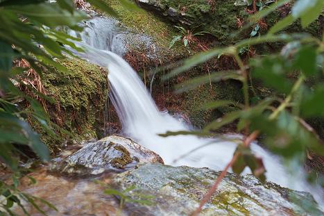
Picture: Tumbling Brook on Glen River
jkerr on Slieve Donard
by jkerr
4 Oct 2005
Slieve Donard being the highest peak in the Mournes offers some fantastic views in reward for walking to the summit. Gaze south over the Carlingford Mountains and beyond Dundalk Bay towards the Wicklow Mountains shimmering seductively on southern horizon. The Isle of Man and a glimpse of Scotland attract the eye eastward with Belfast City easily visible to the north. Lough Neagh completes the cardinal tour to the west.
The Mourne Peaks and Tors dominate the immediate view from south to north laid out below as a 3 dimensional map, tempting further walking and exploration. Indeed, many a day I’ve spent walking here, choosing routes and peaks almost at random.
From the summit delight in the birds eyes view of the local drumlin countryside. Study the low lying land that melds into Dundrum Bay encircled with what looks like end moraine formations. Trace the tree lined rivers that tumble toward the sea. Are they remnants of once torrential glacial outflows? Try and picture in your minds eye the great glacial ice sheets spilling from the mountain valleys sculpting and moulding the terrain laid out below.
There are many and varied accent / descent routes available to the walker each one presenting it's own unique and pleasing characteristics. The tourist route, starting in Donard car park takes you up the Glen River path were it’s fascinating to examine the transition from Silurian bedrock to the younger granite. Follow the path which will lead you all the way to the Mourne wall. On the way stop and study the varied glacial features. The most notable is the Corrie that’s been carved out from the Northern face of Donard. Look out for this as you drive towards Newcastle from Castlewellan, it’s a most prominent feature toward evening. There’s also the glacial spur of Eagle Rock and the Pot of Pulgarve. I always find it awe inspiring to think of the energy required to gouge these formations from the mountains. Anyway, proceeding up the path stop just above the tree line and look left to the rippled surfaces of Thomas’s Mountain. You can still see the layering folds formed in the molten magma as it cooled after being injected into the long gone Silurian overcoat. When you reach the wall swing left and follow it to make your accent to the summit. There’s a stone path leading up the flank of the summit which follows the wall. It’s a bit dicey in places so watch your step if its wet. Just one other thing. For anyone who has regularly walked in the Mournes have you noticed a thin band of red subsoil that is exposed at the riverbanks. Its really noticeable up the Tracey track, does anyone know what this is. Linkback: mountainviews.ie/summit/19/comment/1984/
Read Less
Read More
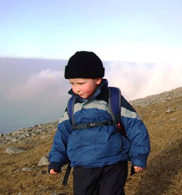
Picture: Tiernan on Slieve Donard
tony on Slieve Donard
by tony
21 Feb 2008
I just thought I would share an interesting story with you. My self and my son Tiernan are keen Hikers and have spent many happy weekends rambling the hills of the mournes. Every weekend Tiernan packs his backpack and checks his kit before we set off. For the last year and a half we have spent most of our time on the route to Slieve Donard from Donard car park. Every weekend Tiernan gets a little bit further than the last time before stopping for his lunch and heading back to the car. On Saturday the 16th February Tiernan made it for the first time to the summit of Slieve Donard. This story might not seem out of the ordinary except for the fact that Tiernan was born on the 17th May 2004 which makes him nearly four years old. Tiernans day was made when some hikers greeted him at the top by shacking his hand and congratulating him. This is a respectful achievement for people of all ages but for Tiernan it was nothing short of incredible. I always bring my camera so I can take loads of pictures and put them on the net for our friends and family. Naturally I have loads of pictures of this particular event which I would be delighted to share with you if you are interested. Linkback: mountainviews.ie/summit/19/comment/2972/
Use of MountainViews is governed by conditions and a privacy policy.
Read general information about the site. Opinions in material here are not necessarily endorsed by MountainViews.
Hillwalking is a risk sport. Information in comments, walks, shared GPS tracks or about starting places may
not be accurate for example as regards safety or access permission. You are responsible for your safety and your permission to walk.
See the credits and list definitions.


 Our Facebook page.