If you want to use the website often please enrol (quick and free) at top right.

 Get Notifications
An Cearcallach: Viewed from Meall Coire Choille-rais
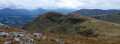 billbaggins
Near Mullacor, Wicklow (Ireland)
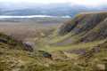
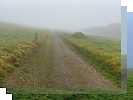
Meall Coire Choille-rais: View south from Puist Coire Ardair
 billbaggins
rema naoum
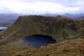
A'Bhuidheanach: Coire nan Gall with Loch Laggan below.
 billbaggins
Croaghmoyle: Easy afternoon walk up popular hill
 bogllama2210
gkortsia petrostrougka kakalos
Dunmurry Hill: Simple walk up tarmac road.
 Collaborative entry
Uninspiring hill accessed by forest tracks
 Colin Murphy
Commaun Beg: Uninspiring hill accessed via forest tracks.
 Collaborative entry
Knockmaroe: Green dome without a lot of interest.
 Collaborative entry
As simple a bag as they com
 Colin Murphy
Use of MountainViews is governed by conditions and a privacy policy.
Read general information about the site.
Opinions in material here are not necessarily endorsed by MountainViews.
Hillwalking is a risk sport. Information in comments, walks, shared GPS tracks or about starting places may not be accurate for example as regards safety or access permission. You are responsible for your safety and your permission to walk.
See the credits and list definitions.
 Visit our Facebook page.
 Length: 8.7km, Creator time taken: 3h38m, Ascent: 643m,
Descent: 645m
Places: Start at S3409210260, Kilclooney Mountain, end at Start
Logged as completed by 1

NOTE: ALL information such as Ascent, Length and Creator time taken etc should be regarded as approximate. The creator's comments are opinions and may not be accurate or still correct.
Your time to complete will depend on your speed plus break time and your mode of transport. For walkers: Naismith's rule, an approximate though often inaccurate estimate, suggests a time of 2h 49m + time stopped for breaks
NOTE: It is up to you to ensure that your route is appropriate for you and your party to follow bearing in mind all factors such as safety, weather conditions, experience and access permission.
* Note: A GPS Height in the elevation profile is sourced from the device that recorded the track. An "SRTM" height is derived from a model of elevations for parts of the earth. More detail![]()
|
|
|
||
| MountainViews.ie, a Hill-walking Website for the island of Ireland. 2400 Summiteers, 1480 Contributors, maintainer of lists: Arderins, Vandeleur-Lynams, Highest Hundred, County Highpoints etc | |||