Cookies. This website uses cookies, which are small text files that the website puts on your device to facilitate operation. Cookies help us provide a better service to you. They are used to track general user traffic information and to help the website function properly.

Click to hide this notice for 30 days.
Welcome to MountainViews
If you want to use the website often please enrol (quick and free) at top right.
Overview
Detail
Zoom: ??
For more map options click on any overview map area or any detail map feature.
Find Suggested Walks
Find hill, mountain, island, coastal feature.
Videos

Recent Contributions
Get Notifications

Milane Hill: Not inviting but OK

Slievemore: Less prickly from North

Long trail to rewarding tops.

Knocknagree East Top: Fine top with good access mostly on trail

Steep ascent, stunning views

Very fine Carn with stunning views.

Mount Gabriel: Simple and stunning

Coomnalack Top: Lacks for nothing

GR 92: Estartit to l'Escala

Little Bin: Tough little climb

GR 92: Roses to Cadaques

Silvermines Hydro Project

Conditions and Info
Use of MountainViews is governed by conditions and a privacy policy.
Read general information about the site.
Opinions in material here are not necessarily endorsed by MountainViews.
Hillwalking is a risk sport. Information in comments, walks, shared GPS tracks or about starting places may not be accurate for example as regards safety or access permission. You are responsible for your safety and your permission to walk.
See the credits and list definitions.
Video display
ColinCallanan: Track 3725 in area near Tievebaun, Dartry Mountains (Ireland)
An enjoyable route up to Tievebaun with stunning views into Donegal.
Length: 6.6km, Creator time taken: 4h13m, Ascent: 448m,
Descent: 488m

Places: Start at G7787648728, Tievebaun, end at G7813648860 292m NE from Start
Logged as completed by 1

This was a very enjayable walk. We started in the carpark which has an information board titled "Eagles rock".

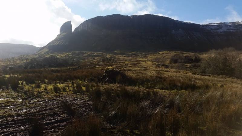
However, after meeting a local farmer he informed us that this information was misleading, and that eagles rock is not the impressive structure in the photo below (let's call it eagles rock 1):

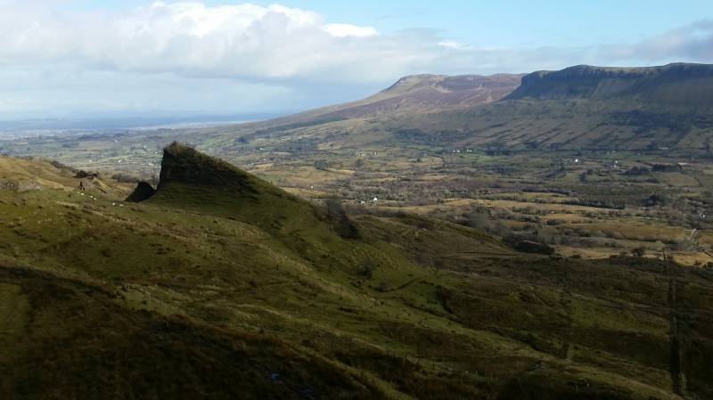
But is actually the following smaller rock, seen on the left in the below image (lets call it eagles rock 2):

From the carpak, a path leads up to this smaller rock structure. The man advised us that we could park in the carpark and take the path up this this smaller rock without any trouble. We said we might consider continuing on to summit Tievebaun and/or Truskmore from there also, and to this the man advised that it would be safe to do this also and there is a way up. We were told that cars had their windows smashed in this carpark, but thankfully I drive an old banger so I wasn't very worried about this.
We found the track up to eagles rock 2 was very good, and would be suitable for young families. It gets very muddy just before you get to the rock, and you'll need to fence hop a bit to get into the rock itself and climb it.
We continued on and found a useful path with switchbacks al the way up to almost 350 metres. This made ascending easy enough, but when you get to the 400m line, I would advise you not to take the route I took in this GPS, but to instead bear more to your left to find a more managable elevation profile. I ended up scrambling and climbing a bit from 400m onwards and some sections were a bit dangerous if you are not used to scrambling in heather and brush. We also had a good bit of snow to contend with so this added to the risk factor.
Views from the top were magnificent, with Slieve league in the distance, as well as the bluestack mountains topped with an icing of snow. The local mountains like keeloges, aroo and aghalateeve all looked magnificent on this sunny day in February, as well as glenade valley and lough. This is a very accessible, short but highly rewarding hike indeed.
A few more photos from the day:


Uploaded on: Sun, 18 Feb 2018 (18:47:51)
Linkback: https://mountainviews.ie/track/3725/  
To download GPS tracks you must be enrolled and logged in. See "Login or enrol", top right - quick and easy.


COMMENTS
No comments uploaded yet.

NOTE: ALL information such as Ascent, Length and Creator time taken etc should be regarded as approximate. The creator's comments are opinions and may not be accurate or still correct.
Your time to complete will depend on your speed plus break time and your mode of transport. For walkers: Naismith's rule, an approximate though often inaccurate estimate, suggests a time of 2h 4m + time stopped for breaks
NOTE: It is up to you to ensure that your route is appropriate for you and your party to follow bearing in mind all factors such as safety, weather conditions, experience and access permission.

* Note: A GPS Height in the elevation profile is sourced from the device that recorded the track. An "SRTM" height is derived from a model of elevations for parts of the earth. More detail

Main mapping:
Open Street Map
(Main supplier OpenTopoMap)
Height layer: © MapTiler
MapTiler Logo
British summit data courtesy:
Database of British & Irish Hills
(Creative Commons Licence)
MountainViews.ie, a Hill-walking Website for the island of Ireland. 2500 Summiteers, 1480 Contributors, maintainer of lists such as: Arderins, Vandeleur-Lynams, Highest Hundred, County Highpoints etc