This website uses cookies, which are small text files that the website puts on your device to facilitate operation. Cookies help us provide a better service to you. They are used to track general user traffic information and to help the website function properly.
wicklore: Track/2293 in area near Black Hill, Dublin/Wicklow (Ireland)
A round of the best of Wicklow bog
Ascent: 814m,
Length: 15.6km,
Creator time taken: 7h17m
Descent: 765m,
Time predicted from Naismith's rule: 4h 29m + breaks
Click here to rate track
PlacesStart at Ballynultagh Gap (BNulta Gp) O04390 10846, Black Hill, Mullaghcleevaun, Mullaghcleevaun East Top, Duff Hill, Gravale, Carrigvore, end at Sally Gap (SalGp) O13017 10997, 8.6km E from Start
Track Rating ..
[RWD version 1 ]
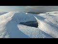
Another route walked with 12-15 year old scouts. This route is wet, boggy, potentially soul destroying and certainly tiring. The upside is a route taking in six of Wicklow's summits including the second highest. If you can organise a drop-off and collection you can walk without fear for your car and end at the Sally Gap. Bring gaitors, mucky bog-crossing experience and plenty of time! Navigation skill is very important in this often cloudy part of the world.
Editing Details for track/2293
NOTE: ALL information such as Ascent, Length and Creator time taken etc should be regarded as approximate. The creator's comments are opinions and may not be accurate or still correct.
Your time to complete will depend on the speed of the slowest plus break time and your mode of transport.
NOTE: It is up to you to ensure that your route is appropriate for you and your party to follow bearing in mind all factors such as safety, weather conditions, experience and access permission.
Uploaded on: Sun, 18 Aug 2013 (20:33:35), Linkback: https://mountainviews.ie/track/2293/
* Note: A GPS Height in the elevation profile is sourced from the device that recorded the track. An "SRTM" height is derived from a model of elevations for parts of the earth. More detail
Use of MountainViews is governed by conditions and a privacy policy.
Read general information about the site. Opinions in material here are not necessarily endorsed by MountainViews.
Hillwalking is a risk sport. Information in comments, walks, shared GPS tracks or about starting places may
not be accurate for example as regards safety or access permission. You are responsible for your safety and your permission to walk.
See the credits and list definitions.


 Our Facebook page.