Cookies.
This website uses cookies, which are small text files that the website puts on your device to facilitate operation. Cookies help us provide a better service to you. They are used to track general user traffic information and to help the website function properly.
Features
Nearby features appear when you click the map.
Declutter tracks on map.
Place Search
Video
X
Pub: by
South East Midlands Area , S: Slievenamon Subarea
Feature count in area: 31, by county: Laois: 6, Carlow: 1, Offaly: 1, Kildare: 2, Kilkenny: 13, Tipperary: 8, OSI/LPS Maps: 28A, 28B, 47, 48, 49, 53, 54, 55, 59, 60
Highest Place: Slievenamon 720.2m

Starting Places (16) in area South East Midlands:
Ballinvarry West, Clodiagh Church, Coolnahau, Coppanagh Wood South, Freney's Well, Glynn, Gorlough Wood, Hill of Allen, Inistioge, Killamery Wood East, Kylebeg Wood, Lingaun River, Mount Alto Wood, Mullenbeg Wood South, Newtown Upper School, Slievenamon Walk Head

Summits & other features in area South East Midlands:
E: Barrow: Clogrennan Hill 336m, Newtown Hill 208m
N Cen: Timahoe Hills: Ballaghmore Hill 268m, Cullenagh Mountain 317m, Fossy Mountain 332m, Hewson Hill 261m
N: Croghan: Croghan Hill 234m
N: Newbridge Hills: Dunmurry Hill 233m, Hill of Allen 219m
S: Mullinavat: Coolnahau Hill 265m, Corbally Hill 285m, Mount Alto 276m, Tory Hill 292m
S: Slievenamon: Knockahunna 502.8m, Sheegouna 553.5m, Slievenamon 720.2m, Slievenamon North-West Top 564m
S: Windgap: Carricktriss Gorse 314m, Carrigadoon Hill 296.9m, Faranaree Hill 283m
SE: Brandon Hill: Brandon Hill 515m, Coppanagh 365m, Croghan 365m
W Cen: Durrow: Ballynalacken Hill 314m, Caponellan Hill 253m, Knockmannon Hill 315m
W Cen: Slieveardagh: Clomantagh Hill 349m, Knocknamuck 340m, Monabrogue 284m
W: Horse & Jockey: Kill Hill 241m, Killough 235m

Note: this list of places may include island features such as summits, but not islands as such.
Rating graphic.
Slievenamon, 720.2m Mountain Sliabh na mBan A name in Irish,
Place Rating ..
(Ir. Sliabh na mBan [OSI], 'mountain of the women'), Tipperary County in Munster province, in Arderin, Vandeleur-Lynam, Irish Highest Hundred Lists, Slievenamon is the highest mountain in the South East Midlands area and the 100th highest in Ireland.
Grid Reference S29857 30729, OS 1:50k mapsheet 67
Place visited by: 490 members, recently by: rosduke, jjbireland700s, patman1974, MichaelG55, LorraineG60, Aidan_Ennis, Leatra, discovering_dann, DarrenY, RosieMc, farmerjoe1, Leona-S, Muscles1960, Marykerry, kieran117
I visited this place: NO (You need to be a logged-in member for this.)
Longitude: -7.561814, Latitude: 52.427683, Easting: 229858, Northing: 130729, Prominence: 711m,  Isolation: 1.1km, Has trig pillar
ITM: 629800 630778
Bedrock type: Red, brown conglomerate & sandstone, (Carrigmaclea Formation)
Notes on name: This mountain is steeped in mythology. The name is derived from the following legend: Fionn Mac Cumhaill sat waiting at the top while women raced up it to win his hand. Since Fionn and Gráinne were in love, he had shown her a short-cut and she duly won the race. Yeats preferred the name Knockfefin. The mountain rises from the plain of Femen, which represents ‘woman’ or ‘femininity’. The song Slievenamon is the Tipperary anthem.
  Short or GPS IDs, 6 char: Slvnmn, 10 char: Slvnmn

Linkback: https://mountainviews.ie/summit/95/
Gallery for Slievenamon (Sliabh na mBan) and surrounds
Summary for Slievenamon (Sliabh na mBan): A distinctive, iconic peak; no challenge to summit but great views abound.
Summary created by markmjcampion, jackill 11 Sep, 2023
            MountainViews.ie picture about Slievenamon (Sliabh na mBan)
Picture: From Knocknalougha
Slievenamon, mountain of the women, is a broad, isolated dome in south Tipperary, not far from Clonmel. It's a conspicuous landmark from all points to the north and commands fine views in all directions, including the Comeraghs, Knockmealdows, Galtees and Mt. Leinster as well as the plains and valleys of south Leinster.

SE. Park on the roadside north of Kilcash at SlMonSE (S31783 28837) just in front of a farmyard. This is a narrow road so park as best you can and careful not to obstruct the farm entrances. A rough signposted track leads off just north of west and when you reach the foresty at A (S31322 28956) The route up from here is on a substantial track and keeps the forestry on its right.
At the top of this track is a concrete bunkhouse with bits of decaying aerial near it. Go past this uphill to the north on a gradual slope to the summit pillar. Allow around an hour to summit.

NE. For a longer route, try to find parking near Lingaun (S31415 32681) and head up the eastern slope of Knockahunna before heading south for Sheegouna and continuing on up the NNE spur of Slievenamon. Allw 2hrs to reach the summit trig pillar.

Notable tracks include track/3032 is a 12k route that takes in all 4 tops in the vicinity.
Linkback: mountainviews.ie/summit/95/comment/4855/
Member Comments for Slievenamon (Sliabh na mBan)

            MountainViews.ie picture about Slievenamon (Sliabh na mBan)
simon3 on Slievenamon
by simon3 6 Dec 2003
One place to start is just north of Kilcash at B (S317 288). (To get to this, go north of Kilcash for about 500m, take a left turn and follow the road for about 400m). Here a rough signposted track leads off to the west, up the mountain. Most of the route up the mountain is on a substantial track, some of it to the west of a forestry plantation.
At the top of this track is a concrete bunkhouse with bits of decaying aerial near it. One possible place to aim for on the flattish summit is a trig pillar as shown below. Linkback: mountainviews.ie/summit/95/comment/766/
Read Less
Read More

            MountainViews.ie picture about Slievenamon (Sliabh na mBan)
Picture: A place to sit and contemplate
History and Folklore
by wicklore 25 Jul 2010
Slievenamon may appear unremarkable, but by digging a little deeper it reveals some quite interesting things. It is a special mountain to the people of Tipperary, and the song ‘Sliabh na mban’ is their county anthem which is sung at sporting and other celebratory events. So protective are the locals of their hill that they were outraged at plans for a windfarm to be developed on its slopes. They successfully challenged this and Slievenamon remains windmill-free today.

The name ‘Slievenamon’ derives from Sliabh na mban, the Mountain of the Women, or Maidens. It is said that Fionn Mac Cumhaill chose his wife by picking the winner from a group of women who raced up the mountain. Grainne won, and it is said Fionn helped her to do so by showing her a shortcut to the top! Slievenamon was also home to a group of Faeries known as the Horned Witches. When these witches caused trouble to a local woman by invading her house she tricked them into leaving by shouting that their mountain, Slievenamon, was on fire. When they left she successfully kept them out for good.
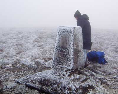
Watch out for Horned Witches on the stony track that leads to the summit. The track makes route-finding simple, and Slievenamon attracts all levels of walkers. Contributors here say it is a 45 minute walk to the top along the track. I would suggest that it is a 45 minute walk for fairly fit, regular walkers. The track is steep in places, and several stops for water or breath may be required. I think it is perfectly ok to say it may take some walkers well over an hour to complete. I make this point as a couple I met on the hill felt bad that they had not reached the summit after an hour’s walking. I encouraged them to go at their own pace.

Slievenamon was the scene of some activity during the 1798 rebellion. In July 1798, a pitched battle occurred between the United Irishmen rebels and Government troops nearby. The rebels were defeated, and some say a betrayal resulted in their swift demise. Slievenamon also featured in later Irish History. In 1922 the British Army handed over 13 Whippet Rolls-Royce armoured cars to the fledgling Irish Free State Government. One of these vehicles was allocated to Michael Collins, who had just been appointed Commander-in-Chief of the rapidly expanding Free State army. Each of the Rolls-Royces was given a name, and the car allocated to Michael Collins was proudly named Slievenamon. Slievenamon was an escort vehicle with machine guns mounted on the day of the ambush of Michael Collins in Beal na Blath.

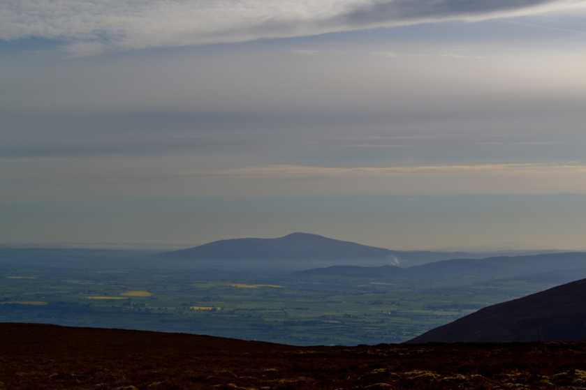
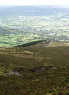
More recently on 26th December ’03, Slievenamon was the scene of tragedy when a businessman from Kilkenny, Tom Manning, died while descending the mountain. A large cairn on the upper reaches of the tourist track bears a plaque dedicated to his memory. There is also a well built ‘Memory Seat’ next to a large cross near the beginning of the access track. From the seat fine views can be had across to the Comeraghs. Linkback: mountainviews.ie/summit/95/comment/5965/
Read Less
Read More

deswalk on Slievenamon
by deswalk 11 Apr 2007
I climbed Slievenamon on 5 April 2007 Easter Week. The weather was extraordinary with high pressure and clear blue sky. I took the popular route signposted as 'Slievenamon Summit' from point SlMonSE (S317 288) just up from Kilcash.I first climbed this in 1980 and the last time before Thursday was about twenty years ago. The track has grown in width over the years and is now almost a road to the summit. However the view is still as magnificent. I was up at the top at 7pm and it was deserted. Superb. Linkback: mountainviews.ie/summit/95/comment/2664/
Read Less
Read More

            MountainViews.ie picture about Slievenamon (Sliabh na mBan)
Picture: Looking south east from Slievenamon
mneary34 on Slievenamon
by mneary34 10 Oct 2005
I climbed Slievenamon from the same starting point as Simon at B (S317 288) just north of Kilcash. The start point is at the 240 metre contour so to the summit at 721 it is a 480 metre climb. The route up is easy to follow along a path all of the way and there are two crests on the route where the subsequent journey is revealed. As others have described there is a cairn, standing stone and trig point at the summit. Great views extend south and to the Comeraghs. This photo shows the route back down. Linkback: mountainviews.ie/summit/95/comment/1997/
Read Less
Read More

bogtrotter_ie on Slievenamon
by bogtrotter_ie 24 Oct 2002
Slievenamon is a much under-rated climb/walk. It's generally viewed as a typical tourist up-the-track and down-the-track linear walk. In fact, a lovely and enjoyable circular route over all the sub-peaks surrounding the main one, circling back via a visit to the Killusty cross is about 10 miles and addords great views of the Suir valley. The route back passes beside one of the last remaining sections of Oak forrest in Ireland. Linkback: mountainviews.ie/summit/95/comment/176/
Read Less
Read More
EDIT Point of Interest
text
Videos

Recent Contributions
x
Conditions and Info
Use of MountainViews is governed by conditions and a privacy policy.
Read general information about the site.
Opinions in material here are not necessarily endorsed by MountainViews.
Hillwalking is a risk sport. Information in comments, walks, shared GPS tracks or about starting places may not be accurate for example as regards safety or access permission. You are responsible for your safety and your permission to walk.
See the credits and list definitions.

OSi logo
OSNI/LPS logo
Open Street Map
(Various variations used.)
British summit data courtesy:
Database of British & Irish Hills