Donation Request 2024

DONATE
Members and Supporters, the MountainViews Committee requests your help to meet the costs of the website and of other activities such as insured events or publications.

You do not have to be logged in to donate.

Welcome to MountainViews
If you want to use the website often please enrol (quick and free) at top right.
Overview
Detail
Zoom: ??
For more map options click on any overview map area or any detail map feature.
Find Suggested Walks
Find hill, mountain, island, coastal feature.
Videos


Recent Contributions
Get Notifications

Crocknapeast: Long walk up windfarm roads.

Double bag mostly on windfarm tracks.

Mulnanaff: Longish walk up windfarm road.

Good, relatively easy double bag

Binbane NE Top: Simple bag from its neighbouring top.

Binbane: Steepish approach to relatively easy Carn.

Lake District: Dale Head Horseshoe

Crucknaree: Magnificent views!

Lake District: Coledale Horseshoe

Dunranhill: Sika deer and sitka spruce

Crocknasharragh: Impressive views on initial ascent.

Longish walk to isolated top

Conditions and Info
Use of MountainViews is governed by conditions and a privacy policy.
Read general information about the site.
Opinions in material here are not necessarily endorsed by MountainViews.
Hillwalking is a risk sport. Information in comments, walks, shared GPS tracks or about starting places may not be accurate for example as regards safety or access permission. You are responsible for your safety and your permission to walk.
See the credits and list definitions.
Video display
Mourne Mountains Area   E: Binnian Subarea
Place count in area: 58, OSI/LPS Maps: 20, 29, EW-CLY 
Highest place:
Slieve Donard, 849m
Maximum height for area: 849 metres,     Maximum prominence for area: 821 metres,

Note: this list of places includes island features such as summits, but not islands as such.
Rating graphic.
Slieve Binnian Mountain Sliabh Binneáin A name in Irish (Ir. Sliabh Binneáin [PNNI], 'mountain of the small peak') Down County in NI and in Ulster Province, in Arderin, Vandeleur-Lynam, Irish Highest Hundred Lists, Granite granophyre Bedrock

Height: 745.9m OS 1:50k Mapsheet: 29 Grid Reference: J32055 23314
Place visited by 846 members. Recently by: JohnHoare, Nailer1967, rhw, Henning86, Courin, MeabhTiernan, westside, Deirdreb, orlaithfitz, davidrenshaw, Magic, Prem, Carolineswalsh, Bob-the-juggler, MarionP
I have visited this place: NO (You need to be a logged-in member to change this.)

Longitude: -5.980057, Latitude: 54.141928 , Easting: 332056, Northing: 323314 Prominence: 350.6m,  Isolation: 0.6km
ITM: 731976 823320,   GPS IDs, 6 char: SlvBnn, 10 char: SlvBnn
Bedrock type: Granite granophyre, (Mourne Mountains granite)

Also simply known as Binnion/Binneán. Dominates views of the Mourne Mountains from Annalong and Kilkeel. The folklore of Mourne explains the name Beanna Boirche as 'peaks of Boirche', a personal name. This character is said to have ruled his kingdom from Slieve Binnian. The name Binneán refers to the rocky tors which outcrop along the summit ridge. E. Estyn Evans, in his book Mourne Country, gives the name of one of these tors as The Buckie. In a discussion of the boats used at Kilkeel and other ports along the Co. Down coast, he explains the name as follows: Other variants of the lugger which old salts speak of, all of them of Scottish types, were the Fifie, Zulu, Banff and Buckie. One of the lesser tors on the long spine of Slieve Binnian is known as the Buckie, a name which was meaningless to me until I saw it from the east against the sky and recognised a vessel in full sail [Estyn Evans, 159]. On the facing page is a sketch showing Slieve Binnian's backbone seen from the east including the Buckie.   Slieve Binnian is the third highest mountain in the Mourne Mountains area and the 80th highest in Ireland. Slieve Binnian is the third highest point in county Down.

Linkback: https://mountainviews.ie/summit/79/
COMMENTS for Slieve Binnian (Sliabh Binneáin) 1 2 3 4 5 Next page >>  
Follow this place's comments
MountainViews.ie Picture about mountain Slieve Binnian (<i>Sliabh Binneáin</i>) in area Mourne Mountains, Ireland
Picture: View of the summit tors
 
Distinctive, steep-sided peak with interesting summit tors and stunning views
Short Summary created by markmjcampion, Peter Walker, jackill  11 Sep 2023
With its summit tors, Slieve Binnian is a most distinctive peak in the SE Mournes. There are fine sea views; the Cooleys and many peaks and valleys of the Mournes are often up for close inspection too.

SE. Park at Carrick Little carpark at J34519 21890 starA, room for 10-15 cars. If busy, note that there is plentiful parking up the lane and at other locations hereabouts for £3 a day; please avoid parking at the roadside. Walk up the farm track, cross a stile and follow the Mourne Wall NW, the ground getting steeper all the time. The beckoning summit is Binnian E Top and, if you like, leave the handrail of the wall to take in this before rejoining the wall and heading for Slieve Binnian. 4km+ Allow 2hrs

SW. Park in the Silent Valley recreation area near J30747 20818 starB. Head for Wee Binnion following a wall on its SW shoulder. It's steep but rewarding. Continue your uphill slog along the wall to the summit tors of SB. There are alternative less steep trails if required. 2 to 2.5 hrs
Also from this starting pt. walk along the reservoir track as far as J32104 25606 starC before taking the obvious track SW and then S over Binnion's N tops before reaching SB after about 12k...3.5 to 4 hrs

S. Park near J31960 20933 starD and follow the trail north until you reach Wee Binnion's SW shoulder and follow the wall to the summit as described earlier. 2 to 2.5 hrs.
Point J32104 25606 starC can also be reached from J34519 21890 starA via a lower trail that skirts Annalong wood.

Track/2286 is an 18k loop taking in 6 mv summits and track/3381 is a long day out that takes in 8 summits. Linkback: https://mountainviews.ie/summit/79/comment/4839/
 
MountainViews.ie Picture about mountain Slieve Binnian (<i>Sliabh Binneáin</i>) in area Mourne Mountains, Ireland
Picture: Approaching the summit tor on Slieve Binnian
kernowclimber on Slieve Binnian, 2010
by kernowclimber  21 Feb 2010
We set off on 20th February from Carrick Little Car Park at around 2.00pm for the summit of Slieve Binnian. The weather was calm, cold but sunny. The Mournes were fog free, but a bank of fog out on the Irish Sea was edging towards the Isle of Man and another was encroaching slowly from the direction of Newry.
We made our way along a muddy farm road and across a stile to continue up the Annalong Valley walking parallel to a fence and then close to the Annalong Woods. The track was quite rugged underfoot and boggy in places but infinitely preferable to the ‘pathway’ the National Trust has laid on the route up to Slieve Donard from Newcastle. As we advanced it became quite icy underfoot and day old snow adhered to the rocks and vegetation on and near the path.
Close to Blue Lough which was frozen, we took the left-hand path towards the saddle between Slievelamagan and North Tor. There is a large boulder here that is fun to clamber onto and offers fine views over the Ben Crom Reservoir. We scrambled up a steep rocky pathway covered with snow towards North Tor, deviating slightly at the top to take in the fabulous view down over the Ben Crom Reservoir. Freshly made rabbits’ paw prints were imprinted in the snow that crisply covered the hillside and glistened magically in the late afternoon sunshine. By now a blanket of impenetrable fog was making its way stealth-like from the direction of the Silent Valley and was slowly encroaching on the Ben Crom Reservoir.
We climbed higher and passed beneath the towering hulk of North Tor towards the Back Castles that were encrusted in snow and small icicles and looked as if they had been foam blasted. Squeezing through a narrow gap between two huge boulders we gained our first view of a frigid Binnian Lough and Slieve Binnian above with its jagged tors drifting in and out of view like an apparition through wisps of fog being blown up from the valley below.
We followed the ridge towards the summit through quite thick snow that had drifted in places, scrambling up onto the tor as the sun was beginning to set. From the summit we were exhilarated to find that we were looking down on dense cloud as if from an airplane. Illuminated eerily by the setting sun, the fog had surrounded Slieve Binnian and only the tops of the highest mountains including Slieve Donard and Slieve Bearnagh were visible.
We made our descent eastwards from the summit down a steep and very slippery snow covered rocky slope to the Mourne Wall that we followed down in the twilight to the iron gate and the stile to connect with the path leading back to the car park. This was undoubtedly the best winter walk we have made so far this winter which took us just under 5 hours. The ruggedness and majesty of the Mournes is breathtaking and apart from one or two walkers in the valley, we had the hills entirely to ourselves. Linkback: https://mountainviews.ie/summit/79/comment/4419/
Your Score: Very useful <<  >>Average
 
MountainViews.ie Picture about mountain Slieve Binnian (<i>Sliabh Binneáin</i>) in area Mourne Mountains, Ireland
Picture: Ben Crom Reservoir from Buzzard's Roost
 
wicklore on Slieve Binnian, 2008
by wicklore  26 Jul 2008
Carrick Little carpark at J 345219 starE was the starting point for my Binnian walk. I followed the track up into the valley via a thoughtful stone stile.
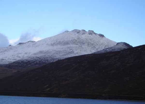
I left the main track and kept close to the wall on my left as I started to climb. I ignored other walls that branched off. The views across the valley and over the Annalong Wood were great with Donard and Commedagh clearly visible to the north.
I eventually climbed over the wall at approx J 327234 starF and headed towards Binnian East Top. A strong wind pushed me up to the summit. Great views to the south towards Slieve Foye and beyond.
I battled the wind back to the wall and followed it up to a stile at approx J 325233 starG. I crossed the stile and headed off to a point between two summit tors. I decided not to just follow the wall as it seemed to head directly to a rocky tor which looked dangerous to climb.
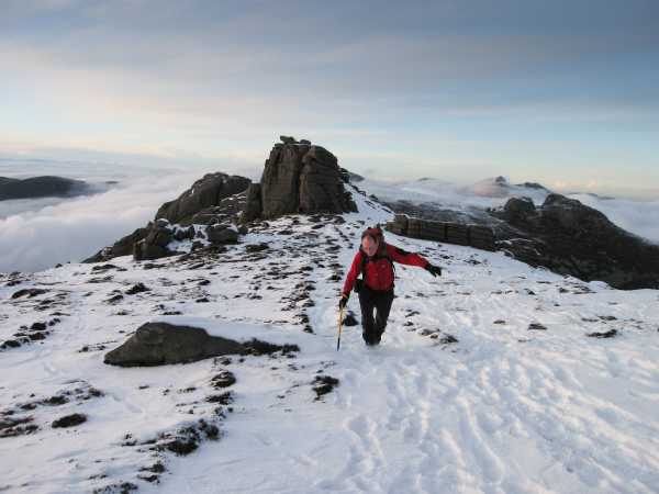
I quickly reached the summit of Slieve Binnian. I enjoyed the amazing views and explored the tors. I expected to find the summit busy but there was no one there. Besides the lack of people I was also amazed at the lack of wildlife-are there no deer or hares in the Mournes?
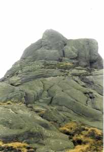
I next headed to Binnian North Top and North Tor, admiring the celebrated Back Castles on the way.
I climbed the North Tor from the East side. It was a spectacular viewpoint and an excellent location for lunch. The first people I saw in the Mournes that day jogged past below- these Mountain Runners are a tough breed! Again I thought it a shame that so few appeared to be out enjoying these beautiful hills.
Next I dropped down to the track at J 321256 starH, admiring the view of Ben Crom Reservoir from Buzzard’s Roost (J319253 starI) on the way. My original plan to head home down the track was abandoned as I headed up Lamagan. Walking alone brings this freedom of deciding on a whim to alter a planned walk.
I found it tough going and I was glad to stop and chat to a couple on the way up. They eagerly named all visible summits, reminding me of my habit of offering to help every time I see a car stopped at Sally Gap in Wicklow with bewildered tourists poring over a map!
After Lamagan I headed NNE into the col at J 331267 starJ and up Cove. The top arrived quickly and I briefly enjoyed the view before heading back to the col and headed SE to find the marked track on the map. This brought me down the side of the bluffs in the area of J 334261 starK where I saw rock climbers hard at work.
I saw people camping in the trees as I passed Annalong Wood which I thought was pleasant until I saw the remains of previous camps. Abandoned torn-down tents, rubbish, old fires and damaged trees. I then met a loud group of lads heading up from the carpark toting crates of beer.
However this didn’t spoil my 7+ hours of bliss in the Mournes. Reading various MV routes is great preparation but “getting out there” will always bring its own unique experiences! I only discovered Simon 3’s Walk Guide for a similar route on MV after my walk but I was happy with my choice! Linkback: https://mountainviews.ie/summit/79/comment/3247/
Your Score: Very useful <<  >>Average
 
MountainViews.ie Picture about mountain Slieve Binnian (<i>Sliabh Binneáin</i>) in area Mourne Mountains, Ireland
Picture: Ravens chasing peregrine falcon near Slieve Binnian
Ravens chasing peregrine falcon near Slieve Binnian
by mush  5 Aug 2021
Great walk up Binnian on the last of the hot days in the heatwave July 23. Had a lovely cooling swim across the Blue Lough after the descent. The best kind of wild swimming.

On the way up saw numerous ravens together, 11 or 12 at one point. They were circling and chasing a large raptor. Took photos with a long lens and it appears to be a peregrine falcon they were chasing. Linkback: https://mountainviews.ie/summit/79/comment/23231/
Your Score: Very useful <<  >>Average
 
MountainViews.ie Picture about mountain Slieve Binnian (<i>Sliabh Binneáin</i>) in area Mourne Mountains, Ireland
 
Jaak on Slieve Binnian, 2006
by Jaak  2 Apr 2006
Top of Binnian, close to the end of a long but very beautiful walk. Started in the car park at the Silent Valley reservoir, followed the road to the Ben Crom dam and then the track to the Hare's Gap. From the Gap, walked to the Castles under Commedagh and then returned to the car park via Beg, Cove, Lamagan, Black Castles, Binnian, wee Binnian and Moolieve. The descent from Binnian was difficult, as apart from the steep incline, the snow covered the holes and cuttings in the rocks and tracks, leading to more than one tumble on the way down.
I walked this route on a number of occasions last Autumn, while training for Kilimanjaro - not really knowing what type of challenge Kili presented. The Mourne walk is much much tougher than any of the climbs en route to the summit of Kilimanjaro, except the final ascent, which is more difficult due to its height and steepness and it has the extra disadvantage of high altitude to put an additional burden on the already tired climber. Linkback: https://mountainviews.ie/summit/79/comment/2252/
Your Score: Very useful <<  >>Average
 
MountainViews.ie Picture about mountain Slieve Binnian (<i>Sliabh Binneáin</i>) in area Mourne Mountains, Ireland
djouce on Slieve Binnian, 2004
by djouce  5 Jan 2004
Slieve Binnian has several spectacular rocky summits. Can be climbed from Silent Valley car park or from a track leaving Head Road at about 319 209 starL. Our route took us over Wee Binnian along the summit of Slieve Binnian to North Tor and then on to Slievelamagan returning via Silent Valley. Time taken 7 hours including breaks. Photo of summit of Slieve Binnian Linkback: https://mountainviews.ie/summit/79/comment/795/
Your Score: Very useful <<  >>Average
 
COMMENTS for Slieve Binnian (Sliabh Binneáin) 1 2 3 4 5 Next page >>
(End of comment section for Slieve Binnian (Sliabh Binneáin).)

OSi logo OSNI/LPS logo
Some mapping:
Open Street Map
(Various variations used.)
British summit data courtesy:
Database of British & Irish Hills
(Creative Commons Licence)
MountainViews.ie, a Hill-walking Website for the island of Ireland. 2400 Summiteers, 1480 Contributors, maintainer of lists: Arderins, Vandeleur-Lynams, Highest Hundred, County Highpoints etc