Cookies.
This website uses cookies, which are small text files that the website puts on your device to facilitate operation. Cookies help us provide a better service to you. They are used to track general user traffic information and to help the website function properly.
Features
Nearby features appear when you click the map.
Declutter tracks on map.
Place Search
Video
X
Pub: by
Mourne Mountains Area , N: Commedagh Subarea
Feature count in area: 58, all in Down, OSI/LPS Maps: 20, 29, EW-CLY
Highest Place: Slieve Donard 849m

Starting Places (33) in area Mourne Mountains:
Alex Steddom Tree, Aughrim Airstrip, Ben Crom Dam, Bloody Bridge Car Park, Carlingford Greenway, Carrick Little, Crocknafeola Wood, Crotlieve Mountain, Donard Car Park Newcastle, Drummanmore Picnic, Fofanny Reservoir, Forest Office CP, Gamekeepers Lodge CP, Happy Valley Trassey Rd, Hen Mountain CP, Leitrim Lodge CP, Mayo Road Corner, Meelmore Lodge, Newcastle Harbour, Ott CP, Red Bog Road, Rourkes Park, Sandy Brae, Silent Valley Reservoir Head Rd, Slieve Donard Trail Head, Slieve Foye Viewing Point, Slievefoy Forest CP, Spelga Dam E, Spelga Dam N, Spelga Dam S, Trassey Car Park, Two Mile River CP, Yellow Water Park

Summits & other features in area Mourne Mountains:
Cen: Loughshannagh: Ben Crom 526m, Carn Mountain 585.2m, Carn Mountain North Top 553.7m, Doan 592.6m, Ott Mountain 526.8m, Slieve Loughshannagh 617m, Slieve Muck 670.4m, Slievenaglogh 445m
E: Binnian: Slieve Binnian 745.9m, Slieve Binnian East Top 639m, Slieve Binnian North Top 678m, Slieve Binnian North Tor 682.5m, Wee Binnian 460m
E: Donard: Chimney Rock Mountain 656m, Crossone 540m, Millstone Mountain 460m, Rocky Mountain 524m, Slieve Donard 849m
E: Lamagan: Cove Mountain 654.8m, Slieve Beg 595.9m, Slievelamagan 702.2m
N: Bearnagh: Slieve Bearnagh 739m, Slieve Bearnagh North Tor 680m, Slieve Meelbeg 701.9m, Slieve Meelmore 687m
N: Castlewellan: Slievenalargy 280m, Slievenaslat 272m
N: Commedagh: Slieve Commedagh 767m, Slieve Corragh 641.9m, Slievenaglogh 584.4m, Slievenaglogh East Top 571m
N: Croob: Cratlieve 429m, Slieve Croob 534m, Slievegarran 391m, Slievenisky 446m
N: Rathfriland: Knockiveagh 235m
S: Kilkeel: Knockchree 306m
S: Rostrevor: Crenville 460m, Finlieve 578m, Slievemartin 485m, Slievemeel 420m, Slievemeen 472m
W: Hilltown: Gruggandoo 382m, Slieveacarnane 296m
W: Slievemoughanmore: Crotlieve Mountain 347m, Eagle Mountain 638m, Rocky Mountain 404m, Shanlieve 626m, Slievemoughanmore 560m, Tievedockaragh 473m, Wee Slievemoughan 428m
W: Spelga: Butter Mountain 500m, Cock Mountain 504m, Cock Mountain South-West Top 505m, Hen Mountain 354m, Pigeon Rock Mountain 534m, Pigeon Rock Mountain South Top 530m, Slievenamiskan 444m

Note: this list of places may include island features such as summits, but not islands as such.
Rating graphic.
Slieve Commedagh, 767m Mountain Sliabh Coimhéideach A name in Irish,
Place Rating ..
(Ir. Sliabh Coimhéideach [PNNI], 'watching/guarding mountain'), Down County in Ulster province, in Arderin, Vandeleur-Lynam, Irish Highest Hundred Lists, Slieve Commedagh is the second highest mountain in the Mourne Mountains area and the 64th highest in Ireland. Slieve Commedagh is the second highest point in county Down.
Grid Reference J34610 28616, OS 1:50k mapsheet 29
Place visited by: 815 members, recently by: Marykerry, eimirmaguire, Daingean, Henning86, rhw, MeabhTiernan, Deirdreb, orlaithfitz, davidrenshaw, Magic, Prem, sprog, Carolineswalsh, ronanmckee, ToughSoles
I visited this place: NO (You need to be a logged-in member for this.)
Longitude: -5.938543, Latitude: 54.188898, Easting: 334610, Northing: 328616, Prominence: 180m,  Isolation: 0.9km
ITM: 734535 828624
Bedrock type: Granite granophyre, (Mourne Mountains granite)
Notes on name: As on Slieve Meelmore, there is a tower near the summit of Slieve Commedagh. On the southern side, at the head of the Annalong Valley, is a spectacular group of granite tors known as 'the Castles'. These can be appreciated from the Brandy Pad, a track once used by smugglers. During the 18th Century the Mourne Mountains were notorious for smuggling commodities such as wine, silk, tobacco, tea and brandy, mainly from Britain. The cargo would be brought ashore under the cover of darkness and taken over the mountains to Hilltown and the surrounding areas.
  Short or GPS IDs, 6 char: SlvCmd, 10 char: SlvCmdgh

Linkback: https://mountainviews.ie/summit/63/
Gallery for Slieve Commedagh (Sliabh Coimhéideach) and surrounds
Summary for Slieve Commedagh (Sliabh Coimhéideach): High, flat- topped coastal peak wirh steep approaches.
Summary created by markmjcampion, Harry Goodman, wicklore 2023-08-18 16:16:31
            MountainViews.ie picture about Slieve Commedagh (<em>Sliabh Coimhéideach</em>)
Picture: Approaching Commedagh from Donard
Commedagh is the 2nd highest Mourne - a col separates it from Donard to the SE. It lies near Newcastle on the E edge of the range and has a broad, grassy top surrounded by steep, heathery approaches. The 35k Mourne Wall passes close by. Fine local views and also the Coolies, Sperrins and Antrim Hills. Beware - steep ground to the NE.

NE. From Donard Park DonCPNc (J37499 30597) take forest track SW through Donard Wood. On exiting the forest a good path continues up the valley to gain the col at the Mourne Wall between Donard and Commedagh A (J35021 27934). Turn right and follow the Wall uphill to reach a stone tower B (J34405 28433). Turn right here and cross the plateau NE for circa 300m to the top. Sea to summit 2.5 hrs

NE. From the same car park walk up to DonTrHd (J36483 29641), turn right and follow the wall thru the trees for about 200m to a forest ride on left. Follow this up to a stile. Once out on open ground continue W over S'namaddy, then SW to Shan Slieve before following the sharp edge of Commedagh around the Pot of Pulgarve to the top. 2.5 hrs

NW. Park at C (J31089 31306) and head for the Hare’s Gap [see separate entry for Slievenaglogh for more comprehensive description). Then head over Slievenaglogh and Slieve Corragh to reach the stone tower mentioned above. Stick close to the Mourne Wall to avoid cliffs to the N.

Commedagh is also part of the 29km+ Mournes’ Sevens which takes in the 7 highest peaks - track/4460

Other notable tracks include linear track/3379 and track/4116.
Linkback: mountainviews.ie/summit/63/comment/4823/
Member Comments for Slieve Commedagh (Sliabh Coimhéideach)
Comment create / edit display placeholder

            MountainViews.ie picture about Slieve Commedagh (<em>Sliabh Coimhéideach</em>)
Bleck Cra on Slieve Commedagh
by Bleck Cra 16 Jul 2006
There are days when nature conspires to make the mountains so beautiful, she breaks your heart. Sunday 28th November 2004 in the Mourne Mountains, was one such day. A wistful, wandering way through a world of up-ended conifers at the hem of Commedagh’s petticoats; snap-dry branches amongst glistening holly and feather-down moss; draw clean blood on barbed wire and emerge on golden pastures to the Pots of Pulgarve: God’s amphitheatre on the Glen River, Dundrum Bay and beyond, where none but the ravens take their seats; so often black misted, but today every lethal rock pinsharp - all pointing down. To an ice-cold wall and drop along the ridge to Hare’s Gap - a canary-coloured winter sun like a match-head: suddenly blazing, suddenly cold as ash, shooting black shadow shafts into silken crags - and at all times the scent of snow in her wake. Meelmore and Meelbeg, from the North and East, grey-cold like wet newsprint and presenting fantastical scenes of ancient Dalriada, as fat satin ravens perform a last night before winter’s cold curtain comes down. Off Bearnagh and East - the root of a rainbow hangs like a huge kite between the lodge and Castewellan, breathing her fairy breath into the glen and suddenly the night looms, casting a palate of blues and lilacs over Binnian-to-Beg; the pace quickens to the saddle and blues melt to pinks and greens and a canter off Donard to the forest road. Night has fallen, the wood whispers; a wide sweep East and below, a carpet of fairy lights from Hilltown to Dundrum, from the Shimna River to Downpatrick. A warm car like a butterfly cucoon, on the Castlewellan Road, South the matt black silhouette of these stunning hills against an ink sky, North a full moon dozing between linen sheets. Linkback: mountainviews.ie/summit/63/comment/1345/
Read Less
Read More

            MountainViews.ie picture about Slieve Commedagh (<em>Sliabh Coimhéideach</em>)
shippy on Slieve Commedagh
by shippy 23 Feb 2005
Picture below shows the first walk of the new Navan hillwalking club (no offical name yet) ,on top of Commedagh .We climbed Donard first , from the carpark , through the forest and up by the glen river.Came back down to the col and followed the brandy pad to see the castles . From there we went to meet the wall again on the other side of Commedagh and followed it to the summit . It's a nice way to climb Commedagh as you get to see the Annalong valley in its entirety .From the summit we headed back down ,via Shan Slieve, towards the forest with great views of Donard on the way. An enjoyable walk for our first one as a club . Linkback: mountainviews.ie/summit/63/comment/1493/
Read Less
Read More

Bleck Cra on Slieve Commedagh
by Bleck Cra 22 Aug 2004
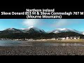
Poor old Commedagh - bass player of the fab five, fronted by Donard and backed by the Bearnagh Sisters.
Dull to look at, heather to trail through, wind to cut you in half. In such wind you can of course open your mouth and do Wallace and Gromit faces - sure we make our own fun.
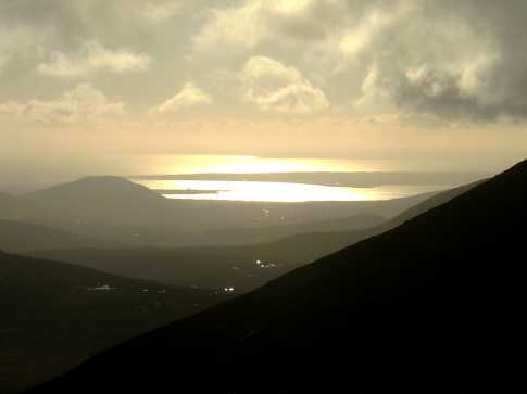
But …… who gives you baffling volcanic globulets? Binnian and Commedagh. Who gives you glorious views of Dundrum Bay? Donard and Commedagh. Who gives you the wickedest drops (from the track)? Cove and Commedagh. Is a pattern not emerging?
Nevertheless in most aspects one cannot underrate Commedagh enough. She is desperately dull to walk, has a thoroughly annoying incline on the Annalong side and thoroughly annoying terrain on the Newcastle side. She is neither bad enough nor good enough. But if you took her show-off neighbours out of the picture, would we not flock to her? Incidentally there are far too many sheep on her.
She stands a sound Corbett 2517 - every inch from sea level. With a bit of vis - sometimes uniquely absent from her peculiar, lonely top, you can see to just about wherever you like, Wicklow, Ellan Vannin, Scotland and worse: North Antrim.
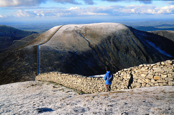
Her pots, the Pots of Pulgarve, are sensational except to the odd unfortunate who occasionally steps out into their infinity: they present a breathtaking tableau of Eagle Rock, Dundrum Bay framed by her and Bro Donard and thousands of fag-smoking ants scurrying up and down the Glen River. And best of all she is one of only 2 spots in the Mournes expanse where you can see raven junior being taught to fly, the old “spare the rod” way. The other, I keep a guarded secret.
Contributor Craigie’s 2 car contortion is fine, but try also Glen River ascent from Newcastle’s Donard carpark with Beginner Book for Boys stroll on to Donard, back down on to The Saddle and up Commedagh. Follow the pots back down Commedagh’s spine into breathtaking vistas and exquisite Donard Wood and back into Donard carpark. Go to pub and enthuse about Commedagh …. endlessly. Linkback: mountainviews.ie/summit/63/comment/1118/
Read Less
Read More

            MountainViews.ie picture about Slieve Commedagh (<em>Sliabh Coimhéideach</em>)
Picture: Commedagh and Shan Slieve from Slievenamaddy
Harry Goodman on Slieve Commedagh
by Harry Goodman 18 Mar 2010
Encouraged by the glorious covering of snow on the High Mournes above Newcastle we climbed Slieve Commedagh on Tuesday 2 March 2010 from Donard Car Park D (J37500 30675). Initially we went up by the Glen River Track to the gate at DonTrHd (J36450 29625) before turning right and following the forest wall along to a fire break at E (J36350 29750), then up left (SW) to cross a stile out on to the open hillside. Once across we headed W up to and over the rocky face of Slievenamaddy, the first part of the approach to Commedagh. From here we continued to follow the ridge up to and past the cairn on Shan Slieve, around the edge of the Pot of Pulgarve to our left before making the final climb up to the summit of Commedagh at 767m F (J34600 28600). It is also worth noting that climbing the mountain from Donard Park means that you climb the full height from sea level. While our climb up the snow slope was at times slow, but steady, the reward at the top was well worth the effort. Before us in all directions were the snow covered High Mournes. Having taken in the magnificent panorama we made the short descent across Commedagh's flattish top to the Mourne Wall and Shelter Tower G (J34000 28475) were we had our lunch sheltered from the strong wind that had been in our face during the climb. While the snow we experienced on the way up had been extensive in its cover we were surprised to find that it was deep enough, in places, to allow us to walk up and over the wall. Once fed and watered we dropped down to the saddle between Commedagh and Donard. Our original intention had been to descend by the Glen River Track NNE back to Donard Park but the prevailing snow conditions and the knowledge that they would soon be gone spurred us on to climb Donard before dropping down NE past the Lesser Cairn and then NNE over Millstone Mountain. From there we descended NNW down the ridge and around the quarry fence to the forest track which we then followed NW down to the Glen River and down to the start at Donard Park. This is a circuit that I would commend to any one wishing to climb the two highest mountains in the Mournes (as well as the highest peak in Ulster) with a third top (Millstone ) for good measure. Linkback: mountainviews.ie/summit/63/comment/4521/
Read Less
Read More

Cascade River circuit
by hbowman1 31 Oct 2010
I climbed this mountain yesterday as part of a circular walk which included Luke's Mountain, Slieve Corragh and Shanslieve. Starting off from Meelmore Lodge, we followed the lane up to the stile and headed towards the Trassey track. After a short while on this track we turned left and headed towards Luke's Mountain. The terrain is very marshy and pathless at times, and as such I would strongly recommend gaiters. This was my first time on Luke's Mountain; it offers very nice views of Slieve Croob, Murlough bay and Tollymore forest. Thereafter we headed alongside the valley between Corragh and Commedagh. The terrain is quite steep on the ascent of Corragh. After reaching the Mourne wall at Corragh we turned left and made our way to the summit of Commedagh. Cloud formations and gusts of wind produced a great atmosphere as mountains, previously covered in cloud, appeared gradually as the mist cleared. After a short break on Commedagh, we headed NW over the ridge between Commedagh and Shanslieve. This is a very good ridge walk in the Mournes, but one which I would not advise in poor visibility, as it is quite steep on both sides. Upon reaching Shanslieve, very fine views opened up of Newcastle, Murlough Bay, Bernagh, Corragh, Slievenaglogh and Meelmore. The descent towards the valley is very steep and walking poles are an advantage. Care must be taken when crossing the river towards Luke's mountain. The full walk took 7 hours, but one which I would recommend - tollymore forest, ridge walk between Commedagh and Shanslieve and the views from Shanslieve - being the notable highlights. This was the first time I had climbed Commedagh from Meelmore Lodge; other possible approaches would be Trassey track up to Hare's Gap and follow the wall over Slievenaglogh and Corragh, and Donard Car park to the saddle and turn left at the wall. Another option would be starting at Donard park, ascending Shanslieve and turning left towards the summit. While all four approaches are viable, I think the best approach is starting from Meelmore Lodge or Trassey. The views of Tullymore forest and from the Mourne wall at Corragh are more interesting than the valley between Donard and Commedagh. Linkback: mountainviews.ie/summit/63/comment/6156/
Read Less
Read More
EDIT Point of Interest
text
Videos


Recent Contributions
x
Conditions and Info
Use of MountainViews is governed by conditions and a privacy policy.
Read general information about the site.
Opinions in material here are not necessarily endorsed by MountainViews.
Hillwalking is a risk sport. Information in comments, walks, shared GPS tracks or about starting places may not be accurate for example as regards safety or access permission. You are responsible for your safety and your permission to walk.
See the credits and list definitions.

OSi logo
OSNI/LPS logo
Open Street Map
(Various variations used.)
British summit data courtesy:
Database of British & Irish Hills