This website uses cookies, which are small text files that the website puts on your device to facilitate operation. Cookies help us provide a better service to you. They are used to track general user traffic information and to help the website function properly.
Feature count in area: 16, all in Kerry,
OSI/LPS Maps: 71, EW-DC, EW-DE
Highest Place: Baurtregaum 849.7m
Starting Places (15) in area Slieve Mish: Caherconree Scenic Route, Derrymore West Trail, Doonore South, Emlagh Cross, Emlagh Wood, Feighatidura Cove, Glanaskagheen Wood, Greenlawn Cross, Laharn Viewpoint, Lougher, Maum Cross, Maumnahaltora Cross, R561 Lissaroe, Tonavane Cross, Tonavane Walk Kerry Camino
Summits & other features in area Slieve Mish: Cen: Baurtregaum: Baurtregaum 849.7m, Baurtregaum Far NE Top 601.2m, Baurtregaum NE Top 818.5m, Baurtregaum NW Top 723m, Caherconree 835m, Castle Hill 600m, Gearhane 792m E: Barnanageehy: Barnanageehy 561m W: Aughils: Beenduff 515m, Caherbla 585.2m, Emlagh 483m, Knockbrack 459m, Knockmore 565m, Lack Mountain 465m, Moanlaur 566m W: Camp: Corrin 332m
Note: this list of places may include island features such as summits, but not
islands as such.
Knockbrack, 459mHill An Cnoc Breac A name in Irish,
Place Rating ..
(Ir. An Cnoc Breac [TCCD], 'the speckled hill'), Kerry County in Munster province, in Carn Lists, Knockbrack is the 703rd highest place in Ireland.
Grid Reference Q70233 05059,
OS 1:50k mapsheet 71 Place visited by: 62members, recently by: muddyboots, maoris, garrettd, a3642278, johncusack, Grumbler, Taisce, chelman7, Moses, Marykerry, John.geary, mh400nt, daitho9, jlk, Ulsterpooka
I visited this place: NO (You need to be a logged-in member for this.)
Longitude: -9.897966, Latitude: 52.182543, Easting: 70233, Northing: 105059,
Prominence: 36m, Isolation: 0.7km ITM: 470211 605113 Bedrock type: Conglomerate with metamorphic clasts, (Inch Conglomerate Formation) Notes on name: Overlooks a hollow to the north called Coumastabla.
Short or GPS IDs, 6 char: Knc459, 10 char: Knockbr459 Linkback: https://mountainviews.ie/summit/589/
Gallery for Knockbrack (An Cnoc Breac) and surrounds
Summary
for Knockbrack (An Cnoc Breac):
Easy ascent from east
Summary created by Colin Murphy
2014-11-27 10:01:20
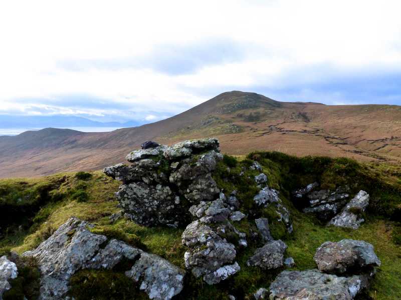
Picture: Summit area, with Moanlaur to the west
Park at A (Q717 056) A, the highest point of the Aughils to Camp road, where there is room for 1/2 cars. Head directly west, the ground cover being knee-high heather for about 1km. The slope gradually increases and becomes quite steep at around 400m ascent. The heather disappears and the terrain is mostly grass and rock, and firm underfoot, (despite recent heavy rain) and after 1.5km you will reach the summit of Knockbrack at 459m, a longish area with the highest point, which is at the eastern end, being quite indistinct. There are some rocky outcrops a couple of metres lower at the western end (pictured). 45 minutes from car to summit.
Parked at MaumHal X (Q687 065), just before a gate on the Dingle Way & followed the Dingle Way for a short before turning left onto a track and then right at the next junction. Followed tracks then a bog road to a small land slide, complete with buried dead sheep in its debris at B (Q698 054), this hides the start of the upper track, but its just as easy to head straight up hill as the gradient eases quickly. A fine view point for eating your lunch at, from here it was only a short walk to Lack. From continuation see Lack... Linkback: mountainviews.ie/summit/589/comment/4124/
Use of MountainViews is governed by conditions and a privacy policy.
Read general information about the site. Opinions in material here are not necessarily endorsed by MountainViews.
Hillwalking is a risk sport. Information in comments, walks, shared GPS tracks or about starting places may
not be accurate for example as regards safety or access permission. You are responsible for your safety and your permission to walk.
See the credits and list definitions.


 Our Facebook page.