Cookies.
This website uses cookies, which are small text files that the website puts on your device to facilitate operation. Cookies help us provide a better service to you. They are used to track general user traffic information and to help the website function properly.
Features
Nearby features appear when you click the map.
Declutter tracks on map.
Place Search
Video
X
Pub: by
Derryveagh Mountains Area , Cen: Slieve Snaght Subarea
Feature count in area: 38, all in Donegal, OSI/LPS Maps: 1, 11, 2, 6
Highest Place: Errigal 751m

Starting Places (29) in area Derryveagh Mountains:
Aleahan Lough, Altderry Bridge, An Chúirt Hotel, Astelleen Burn Waterfall, Derryreel Lough, Dunlewy Lough E, Dunlewy Lough Viewing Point, Errigal Hostel, Errigal Parking, Glenveagh Bridge, Glenveagh National Park SW, Glenveigh Castle, Keel Lough N, Losset North, Lough Acrobane Farmhouse, Lough Ascardan, Lough Barra Slipway CP, Lough Barra W, Meenagoppoge Burn Bridge, Mín Uí Bhaoil, Muckish Gap Shrine, Muckish North Access Road, Nabrackbaddy Lough, Procklis Lough, River Barra Bridge NE, River Barra Bridge SW, Sand Lough NE, Sruhancrolee Bridge, Stranamarragh Bridge

Summits & other features in area Derryveagh Mountains:
Cen: Dooish: Dooish 651.5m, Dooish SW Top 528m, Dooish SE Top 553.9m, Saggartnadooish 506.4m, Saggartnadooish East Top 478.9m
Cen: Errigal: Errigal 751m, Mackoght 555m
Cen: Glenveagh Upper: Crockfadda 485m, Crockfadda East Top 454m, Crockballaghgeeha 480m, Crockmulroney 430m, Staghall Mountain 486m, Croaghnasaggart 480m, Maumlack 480m
Cen: Lough Keel (Meencorwick): Crockglass 489m, Addernymore 416m, Grogan More 457m, Crocknafarragh 517m, Crocknafarragh SE Top 470m
Cen: Slieve Snaght: Crockfadda 529m, Crockfadda NE Top 502m, Crocknasharragh 495m, Drumnalifferny Far NE Top 535m, Bingorms 578m, Drumnalifferny Mountain 596m, Drumnalifferny Mountain NE Top 585m, Slieve Snaght 678m
N: Aghla: Aghla Beg 563.9m, Aghla Beg South Top 602.3m, Aghla More 581.2m, Ardloughnabrackbaddy 472.5m, Crocknalaragagh 470.6m
N: Muckish: Muckish 667.1m, Croaghaderry 222m, Crockawama 238m, Derryreel 232m
S: Doochary: Croaghleconnell 266m
S: Dungloe: Crovehy 315m

Note: this list of places may include island features such as summits, but not islands as such.
Rating graphic.
Slieve Snaght, 678m Mountain Sliabh Sneachta A name in Irish,
Place Rating ..
(Ir. Sliabh Sneachta [DUPN], 'mountain of snow'), Donegal County in Ulster province, in Arderin, Vandeleur-Lynam, Irish Best Hundred, Irish Highest Hundred Lists, Sliabh Sneachta is the second highest mountain in the Derryveagh Mountains area and the 150th highest in Ireland. Sliabh Sneachta is the second highest point in county Donegal.
Grid Reference B92362 14812, OS 1:50k mapsheet 1
Place visited by: 315 members, recently by: rhw, mdehantschutter, MeabhTiernan, jellybean, Nomad691, davidrenshaw, Carolineswalsh, ConMack23, ToughSoles, Sonyalaw, Jimmy600leavey, garybuz, Paddym99, Carolyn105, michaelseaver
I visited this place: NO (You need to be a logged-in member for this.)
Longitude: -8.120048, Latitude: 54.980753, Easting: 192362, Northing: 414812, Prominence: 403m,  Isolation: 0.9km
ITM: 592315 914798
Bedrock type: Coarse biotite granite & granodiorite, (Main Donegal Granite)
Notes on name: There are two mountains of this name in Donegal, the other one being in Inishowen.
  Short or GPS IDs, 6 char: SlvSng, 10 char: SlvSnght

Linkback: https://mountainviews.ie/summit/142/
Gallery for Slieve Snaght (Sliabh Sneachta) and surrounds
Summary for Slieve Snaght (Sliabh Sneachta): Rugged highpoint on a gnarly, rocky SW-NE ridge
Summary created by markmjcampion, jackill 2023-09-14 17:44:24
            MountainViews.ie picture about Slieve Snaght (<em>Sliabh Sneachta</em>)
Picture: The top of Snaght touches the clouds, from Errigal
Slieve Snaght, just S of Erigal, is a steep-sided sentinel mountain in an area of interesting but dangerous terrain. Much care is needed esp if parking to the S. Views are stunning including Erigal, the Aghlas and many of Glenveagh peaks as well as the N Bluestacks and out to some of the offshore islands.

S. Park at Barra Slip (B92918 12363) room for 5-6 cars. Walk NE along the road for 1km, cross the fence on left and follow the Sruhancrolee stream NW over marshy ground before ascending steeply next to a small waterfall. The slope is less steep as you cross a boggy km W to the small summit cairn of Crockfadda. Move on to Crockfadda NE then look for a steep gully rising up the side of Slieve Snaght to the E. Climb the gully to the more gently sloping summit. 2hrs+
You can also reach Crockfadda from the same starting point by going SW along the road until you reach less steep ground on your right [approx. Barra W (B92287 11520)]

SE. Start at approx. A (B95073 14111), first climbing Drumnalifferny and descending to B (B93327 15246) before dropping carefully down to the N shores of Lough Slievesnaght and ascending steeply but without danger to SS. 2.5hrs+

N. Park in Dunlewy near C (B92955 19107) and aim for D (B93246 18060) on the NNW spur of Drumnatifferny. Continue along the spur to approx. E (B93513 16909) and then contour oround until you are above Loiugh Maam. From here aim for the obvious col at F (B93088 15254). From here ascend steeply to SS. Allow 2hrs+

Notable tracks incl. track/4026 and track/3114
Linkback: mountainviews.ie/summit/142/comment/4902/
Member Comments for Slieve Snaght (Sliabh Sneachta)
Comment create / edit display placeholder

            MountainViews.ie picture about Slieve Snaght (<em>Sliabh Sneachta</em>)
zeaphod on Slieve Snaght
by zeaphod 19 Dec 2005
Finally up here on Sat past, much easier than I had anticipated. Park at the head of the Poison Glen and basically make a bee line for the Snaght/Drumnaliffern col. One hour to cross the initial bog plain (at a good pace - the midges forbade stopping!) then the ground dries up considerably. Very easy pull up to the summit, two hours in total to the top. Fantastic views (I could just make out Ben Bulb in Sligo) mean I will be back - as the b****dy batteries died after a few shots! (spares left in the caravan earlier, most useful). A really wild and special place. One of the best lunch venues I have encountered for all round views. Warning, after wet weather/poor visibility the bog crossing on this route will be very unpleasant and difficult, my walk was after a week of almost no rain.
As an update, I headed up again last week (with fresh and spare batteries!). Following the Devlin river to just below the first lough, then heading straight for the col described above will save some "bog trotting" Crossing just above the lough not recommended - long grass and heather, with bog underneath - very "interesting" For the nature lovers, lots of huge dragonflies along the route. We met two Norweigans on the summit, equipped with huge packs, kettle and stove etc. Linkback: mountainviews.ie/summit/142/comment/1781/
Read Less
Read More

            MountainViews.ie picture about Slieve Snaght (<em>Sliabh Sneachta</em>)
Picture: Snaght from Drumnalifferny Ridge, Loch Slieve Snaght to left
Lovely Autumn Walk
by Vikingr2013 7 Oct 2013
Climbed Slieve Snaght and took in Drumnalifferny on Sunday 22nd September 2013. We approached the mountain from the Doochary Road side (R254), parking the car on the bridge at (IG G (B9343 1290)), ascending the coomb to the south of Snaght and descending the coomb to the north.

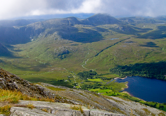
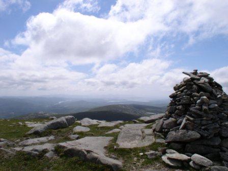
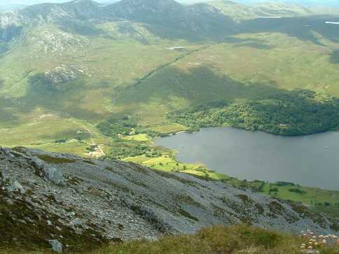
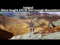
From the car we headed straight into the coomb, keeping the Sruhancrolee river to our left. This coomb is always wet underfoot, even in the driest of summers, and anybody walking here can expect to have wet feet and caked bog up to your knees. We then climbed on the right hand side of Scardangal Burn waterfall (marked on OS map). This was pretty hard going, wet and steep. A safer alternative would be to walk all the way into the coomb and ascend onto the ridge. When we finally ascended the waterfall the weather had cleared and we walked steadily around and up, corkscrewing to the top of Slieve Snaght. The view was spectacular on this rare and beautiful autumn day (see pic’s).

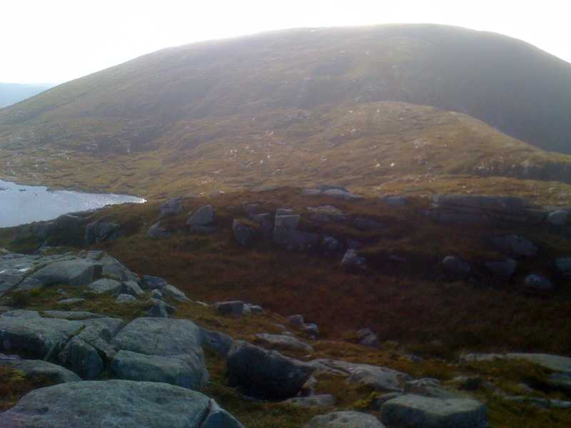
From the top of Snaght we descended to the northern end of Slieve Snaght Loch. We then climbed to the cleft of Drumnalifferny/Bingorms ridge (IG 
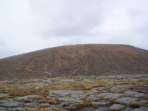
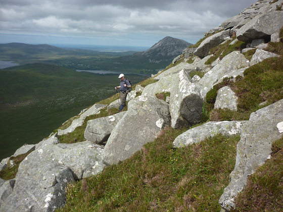
H (B9333 1525)) and took in the top of Drumnalifferny as a wee extra. We descended to the cleft point again to descend into the coomb to the east of this position. It is useful to remember this point as mists can descend very quickly on these mountains and if you are too far to the south, you can easily find yourself at the top of the Bingorm cliffs, where you do not want to be in a mist!

We descended into the coomb of the Scardandoo stream (marked on OS map) in loose order. This coomb is always very wet, boggy, full of hidden watercourses, holes and slippery rocks and you could very easily twist or break an ankle! So take it easy and slowly. Wet and mucky, but unharmed, we eventually reached the road again beside a bridge (IG I (B9440 1383)) and walked a kilometre back to the start-point.

This is definitely a moderate to difficult walk. We took our time, five hours for the whole thing. Not a midge in sight! Linkback: mountainviews.ie/summit/142/comment/15217/
Read Less
Read More

            MountainViews.ie picture about Slieve Snaght (<em>Sliabh Sneachta</em>)
Picture: Slieve Snaght from Bingorms summit
eflanaga on Slieve Snaght
by eflanaga 20 Apr 2006
(Climbed April 17th – see Bingorms for previous stage in walk). From the summit of Bingorms there is a short albeit fairly steep drop over boulder-strewn slopes into Scardangal Burn (J (B93017 14526)). The descent is not so difficult so long as care is taken. This would be especially pertinent in wet conditions when the boulders may become treacherous for the unwary. I crossed a small stream and climbed for about thirty metres until I reached a large boulder. Here, I decided to stop for lunch. I re-commenced my climb up the boggy eastern slope of Slieve Snaght. Having rested I thought I was up to the steeper climb. My left knee thought better of it and was beginning to object strongly to the pressure it was being put under. In hindsight it might have been better to drop a little further south into the Burn from Bingorms so as to climb Snaght’s south-eastern slope - the gradient at this end appears less steep. However, I persevered until I topped Snaght arriving at its summit through a heavy veil of mist. I carried out some running repairs on the knee (bandage) sheltering behind the summit cairn. The mist cleared after a short time allowing me to see my final two targets; Crockfadda North-East Top & Crockfadda. Linkback: mountainviews.ie/summit/142/comment/2286/
Read Less
Read More

            MountainViews.ie picture about Slieve Snaght (<em>Sliabh Sneachta</em>)
skyehigh on Slieve Snaght
by skyehigh 6 Apr 2005
For those who find it more convenient to climb Slieve Snacht from Dunlewy, this view from Errigal clearly shows the course of the Devlin River beyond the old church. One option is to walk upriver for two miles, then after a boggy patch follow a tributary to the left, eventually attaining the col to the right of the summit. In this picture, unfortunately, the target resembles a topped boiled egg. Linkback: mountainviews.ie/summit/142/comment/1598/
Read Less
Read More

            MountainViews.ie picture about Slieve Snaght (<em>Sliabh Sneachta</em>)
Picture: Walker descending Slieve Snaght
Platform to a simply magnificent panorama.
by Harry Goodman 11 Aug 2012
On previous climbs of Slieve Snaght I had always approached from Dunlewy or from along the Dooish to Slieve Snaght ridge. I therefore took the opportunity on 26 July 2012 to climb it from the S, up from the R254, in order to access four tops not previously climbed, Bingorms on it's E side and Crockfadda NE Top, Crockfadda and Crocknasharragh to the W with Drumnalifferny Mt thrown in for good measure. ( For earlier parts of route see my comments on Bingorms and Drumnalifferny Mt.) From the rocky ground just N of L Slievesnaght I climbed up the ridge which runs down the NE side of the mountain. The bonus for including Slieve Snaght in my round was a simply magnificent 360 degree panorama of the hills and mountains of NW Donegal and those further afield Slievetooey, Slieve League and even the distant prow of Ben Bulbin. From the summit cairn I dropped down SW over a steep, rocky and heather/grass covered slope where care was needed to avoid hidden holes, to arrive at a boggy saddle K (B918 145) below my next objective Crockfadda NE Top. Linkback: mountainviews.ie/summit/142/comment/14744/
Read Less
Read More
EDIT Point of Interest
text
Videos


Recent Contributions
x
Conditions and Info
Use of MountainViews is governed by conditions and a privacy policy.
Read general information about the site.
Opinions in material here are not necessarily endorsed by MountainViews.
Hillwalking is a risk sport. Information in comments, walks, shared GPS tracks or about starting places may not be accurate for example as regards safety or access permission. You are responsible for your safety and your permission to walk.
See the credits and list definitions.

OSi logo
OSNI/LPS logo
Open Street Map
(Various variations used.)
British summit data courtesy:
Database of British & Irish Hills