This website uses cookies, which are small text files that the website puts on your device to facilitate operation. Cookies help us provide a better service to you. They are used to track general user traffic information and to help the website function properly.
Feature count in area: 27, all in Antrim,
OSI/LPS Maps: 14, 15, 4, 5, 8, 9
Highest Place: Trostan 550m
Starting Places (3) in area Antrim Hills: Donalds Carn, Rathlin Island Ferry Port, Whitehead Golf Club
Summits & other features in area Antrim Hills: Cen: Central Antrim Hills: Carncormick 436m, Collin Top 429m, Crockalough 402m, Mid Hill 440m, Skerry Hill 459m, Slieveanorra 508m, Slievenahanaghan 418m, Soarns Hill 403m, Tievebulliagh 402m, Trostan 550m Central Antrim Hills: Slievenanee 543m N: North Antrim Hills: Carnanmore 379m, Croaghan 417m, Crockaneel 403m, Cross Slieve 206m, Knocklayd 514m, Lannimore Hill 207m N: Rathlin Island: Kilpatrick (Rathlin Island) 134m S: Islandmagee: Donalds Carn 141m, Muldersleigh Hill 131m S: South Antrim Hills: Agnew's Hill 474m, Big Collin 353m, Black Hill 381m, Carnearny 319m, Douglas Top 402m, Slemish 437.9m W: West Antrim: Long Mountain 215m
Note: this list of places may include island features such as summits, but not
islands as such.
Muldersleigh Hill, 131mHill
Place Rating ..
, Antrim County in Ulster province, in Binnion Lists, Muldersleigh Hill is the 1493th highest place in Ireland. Muldersleigh Hill is the second most southerly summit and also the second most easterly in the Antrim Hills area. It's also the 4th most easterly summit in Ireland.
Grid Reference J47954 93825,
OS 1:50k mapsheet 15 Place visited by: 20members, recently by: Paddym99, garybuz, Kirsty, Carolyn105, Vfslb1904, dregish, Hoverla, trostanite, eamonoc, Fergalh, Wilderness, LorraineG60, MichaelG55, pdtempan, AntrimRambler
I visited this place: NO (You need to be a logged-in member for this.)
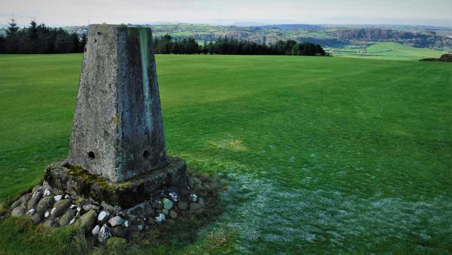
30/1/2019. After a tough drive up Donalds Carn, headed towards Muddersleigh hill which was clearly visible to the South. Arrived at entrance to Whitehead Golf Course, was greeted by a sign indicating that Golf Course was closed, I met a few disgruntled Golfers who were discussing not being allowed play, after greetings were exchanged they played no real heed to me or why I was there. So I headed away from the clubhouse over frozen fairways towards the Trig Pillar, happy not to be ducking away from any misplaced drives from the third Tee box. An interesting hill with great views over the Irish Sea. Linkback: mountainviews.ie/summit/1365/comment/20395/
Read Less
Read More
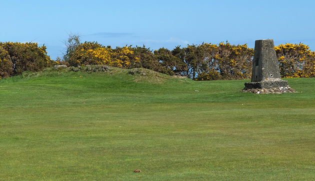
Picture: The top of Muldersleigh Hill with the high point to left of the Trig Pillar
Could this be Ireland's most visited hill top?
by Harry Goodman
18 Apr 2014
Although just over 130m in height this is a hill that could possibly lay claim to be the most visited top in Ireland. Well over 200 people climb it every Saturday between April and October and substantial numbers do likewise on most other days throughout the year. The top, marked by a trig. pillar is approached over well cared for grass and commands excellent views E out across the Irish sea and S over the head of Belfast Lough to the North Down coastline. The trig pillar A (J47955 93812) lies plumb in the centre of the third fairway at Whitehead Golf Course and is crossed daily by members and visitors to the club. On 14 April 2014 I parked in the club car park W'hd GC (J47614 93241) and sought permission at the Pro Shop to walk up to the trig. pillar, permission that was readily given. The walk up and back was about 1.25km with an ascent of only 60m. Once there I found that the trig pillar was not actually the highest point, this being reserved for a small, rough but low stony bank a few metres away (see photo). For completeness I also walked some 150m further E, along the fairway to a small grassy rounded mound B (J48070 93795) that may or may not be marginally higher than the rocky bank beside the trig. pillar. Anyone considering a visit should bear in mind the location of the top and do so when golf competitions are not being held. Linkback: mountainviews.ie/summit/1365/comment/16018/
Use of MountainViews is governed by conditions and a privacy policy.
Read general information about the site. Opinions in material here are not necessarily endorsed by MountainViews.
Hillwalking is a risk sport. Information in comments, walks, shared GPS tracks or about starting places may
not be accurate for example as regards safety or access permission. You are responsible for your safety and your permission to walk.
See the credits and list definitions.


 Our Facebook page.