Guestuser: Login or enrol?
- Home
- Main Display
- Main Display (Old)
- Find a Walk
- Display INTRODUCTION
- DONATE
- Click below for your
profile & contributions
guestuser- New
- Tracks, Walks
- Challenge
- Community
- Lists & Logs
- Popular Lists:
- County Highpoints
- Range & Area Highpoints
- Local 100
- Highest Hundred
- Vandeleur-Lynams
- Arderins
- Carns
- Best rated
- Irish 900 up
- Irish Island
- Munros
- All Lists
- Shorter Irish
- County Highpoints
- Range & Area Highpoints
- Highest Hundred
- Local 100
- Local 100 (pre2014)
- Local Historical Cultural
- Best rated
- Irish 900 up
- Larger Irish
- Arderins
- Arderin Begs
- Arderins + Arderin Begs
- Vandeleur-Lynams
- Vandeleur-Lynams + Arderins
- Carns
- Binnions
- Highest 50 per Province
- Island Features
- Irish Island
- Coastal Hills
- Irish 600 up
- Irish 500 up
- British
- Munros
- British 600 up
- British 500-600
- British Marilyns
- Comprehensive
- All Irish summits
- All Irish features
- All British summits
- All Britain+ Ireland
- Special
- Analysis List
- Simple Irish Listings
- Simple Irish & British Listings
-
- More
- Motley Views
Welcome to MountainViews
If you want to use the website often please enrol (quick and free) at top right.OverviewFor more map options click on any overview map area or any detail map feature.Detail Map FeaturesFind Suggested Walks
Find hill, mountain, island, coastal feature.Videos
Recent Contributions
 Get Notifications
Letterettrin - a perspective on the N Connemara peaks
Carrigroe: Twin tops
Kilbrony Park Ramble
Grieve Hill: Summit position recently revised.
Knocknakilton & Cummeen, Dingle Penninsula
Leean Mountain: Ireland's Best Small Hill?
Scarr North-West Top: Popular spot in the heart of the mountains
Croaghnageer and Croghanirwore
Silvermines Hydro Project
Blackstairs Mountain: Good access and a great viewpoint above a patchwork quilt
Brown Mountain: Granite - mica schist boundary
9 km walk around Mullaghmeen Woods April 2025
Conditions and Info
Use of MountainViews is governed by conditions and a privacy policy.
Read general information about the site.
Opinions in material here are not necessarily endorsed by MountainViews.
Hillwalking is a risk sport. Information in comments, walks, shared GPS tracks or about starting places may not be accurate for example as regards safety or access permission. You are responsible for your safety and your permission to walk.
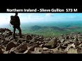
See the credits and list definitions.Video displayGullion Area SE: Ring of Gullion SubareaPlace count in area: 11, OSI/LPS Maps: 28, 29, EW-CLY
Highest place: Slieve Gullion, 573m
Maximum height for area: 573 metres, Maximum prominence for area: 478 metres,
Places in area Gullion:
N: Gullion North:Carrigatuke 365mTullyhappy 209m
SE: Ring of Gullion:Camlough Mountain 423mCotracloghy 225mCroslieve 308mFeede Mountain 233mFoughill 241mHill of Faughart 113mMullaghbane Mountain 243mSlieve Gullion 573mTievecrom 264m
Note: this list of places includes island features such as summits, but not islands as such.
Louth County in Leinster Province, in Binnion List, Porphyritic granophyre Bedrock
Height: 233m OS 1:50k Mapsheet: 29 Grid Reference: J07362 14840
Place visited by 38 members. Recently by: Bernieor, madfrankie, Jai-mckinney, Oscar-mckinney, Dee68, pdtempan, eflanaga, AntrimRambler, Hoverla, trostanite, Kirsty, Carolyn105, atlantic73, abcd, dregishjakeI have visited this place: NO (You need to be a logged-in member to change this.)Longitude: -6.360736, Latitude: 54.071573 , Easting: 307362, Northing: 314840 Prominence: 108m, Isolation: 2.7km
ITM: 707287 814848 , GPS IDs, 6 char: FdMntn, 10 char: FdMntn
Bedrock type: Porphyritic granophyre, (Granite)
Feede Mountain is the 1332th highest place in Ireland. Feede Mountain is the most easterly summit and also the second most southerly in the Gullion area.
Linkback: https://mountainviews.ie/summit/1242/COMMENTS for Feede Mountain 1 of 1  Follow this place's comments
 Height layer: © MapTiler

MountainViews.ie, a Hill-walking Website for the island of Ireland. 2500 Summiteers, 1480 Contributors, maintainer of lists such as: Arderins, Vandeleur-Lynams, Highest Hundred, County Highpoints etc

 glencree
 Colin Murphy
 Collaborative entry
 Geo
Geo
 hibby
hibby
 Peter Walker
 Collaborative entry
 hibby
hibby
 ceadeile
 Visit our Facebook page.