Cookies. This website uses cookies, which are small text files that the website puts on your device to facilitate operation. Cookies help us provide a better service to you. They are used to track general user traffic information and to help the website function properly.
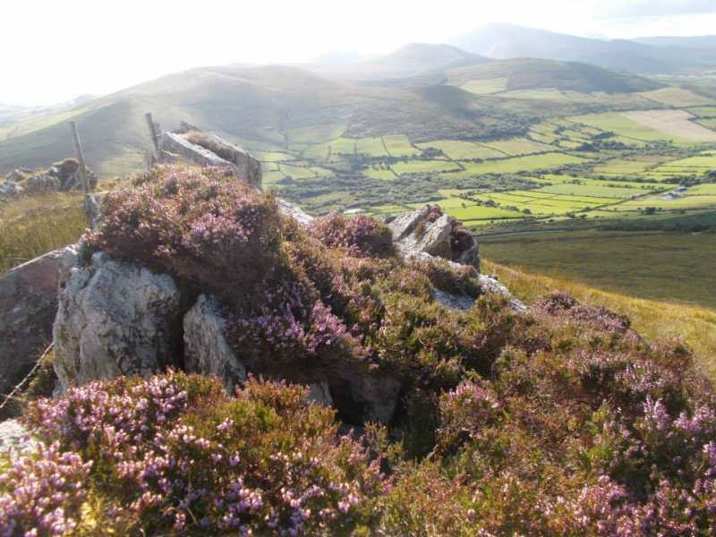
Click to hide this notice for 30 days.
Welcome to MountainViews
If you want to use the website often please enrol (quick and free) at top right.
Overview
Detail
Zoom: ??
For more map options click on any overview map area or any detail map feature.
Detail Map Features
Find Suggested Walks
Find hill, mountain, island, coastal feature.
Videos


Recent Contributions
Get Notifications

Blackstairs Mountain: Good access and a great viewpoint above a patchwork quilt

Carrigroe: Twin tops

Longish, but pretty trek to unremarkable Carn.

Leean Mountain: Ireland's Best Small Hill?

Manorhamilton town centre to the summit of Benbo

Scarr North-West Top: Popular spot in the heart of the mountains

Brandon Hill Loop from Graiguenamanagh

Grieve Hill: Summit position recently revised.

Spain: Circuit of el Dit d'Olta

Brown Mountain: Granite - mica schist boundary

Callahaniska: Simple but very rewarding

Spanish Coastal Walk: Calpe to Monte Toix

Conditions and Info
Use of MountainViews is governed by conditions and a privacy policy.
Read general information about the site.
Opinions in material here are not necessarily endorsed by MountainViews.
Hillwalking is a risk sport. Information in comments, walks, shared GPS tracks or about starting places may not be accurate for example as regards safety or access permission. You are responsible for your safety and your permission to walk.
See the credits and list definitions.
Video display
Slieve Mish Area   W: Camp Subarea
Place count in area: 16, OSI/LPS Maps: 71, EW-DC, EW-DE 
Highest place:
Baurtregaum, 849.7m
Maximum height for area: 849.7 metres,     Maximum prominence for area: 643 metres,

Note: this list of places includes island features such as summits, but not islands as such.
Rating graphic.
Corrin Hill Carraig Thomáisín A name in Irish, also Carraig Tomáisín an extra EastWest name in Irish Ir. Carraig Thomáisín [logainm.ie], 'Thomasina's rock' Kerry County in Munster Province, in no lists, Rhythmically bedded sandstone Bedrock

Height: 332m OS 1:50k Mapsheet: 71 Grid Reference: Q68547 07568
Place visited by 15 members. Recently by: Pizzagirl, chelman7, Pepe, Marykerry, liz50, PPruzina, hivisibility, markmjcampion, eamonoc, Cobhclimber, ciarraioch, trekker, Fergalh, conormcbandon, gallybander
I have visited this place: NO (You need to be a logged-in member to change this.)

Longitude: -9.923573, Latitude: 52.204679 , Easting: 68547, Northing: 107568 Prominence: 97m,  Isolation: 3km
ITM: 468525 607622,   GPS IDs, 6 char: Corrin, 10 char: Corrin
Bedrock type: Rhythmically bedded sandstone, (Ballymore Sandstone Formation)

The anglicised name Corrin appears to be derived from Ir. carn, 'a cairn'.   Corrin is the 1096th highest place in Ireland.

Linkback: https://mountainviews.ie/summit/1112/
COMMENTS for Corrin (Carraig Thomáisín) 1 of 1  
Follow this place's comments
MountainViews.ie Picture about mountain Corrin (<i>Carraig Thomáisín</i>) in area Slieve Mish, Ireland
Picture: Rocky Summit
 
Hidden Gem near Camp
by Fergalh  16 Oct 2020
Parked at Q68106 07569 starA. Climbed gate and with a mixture of track and rough fields headed for the top. Stupendous views in all directions from rock laden top Linkback: https://mountainviews.ie/summit/1112/comment/17636/
Your Score: Very useful <<  >>Average
 
(End of comment section for Corrin (Carraig Thomáisín).)

Main mapping:
Open Street Map
(Main supplier OpenTopoMap)
Height layer: © MapTiler
MapTiler Logo
British summit data courtesy:
Database of British & Irish Hills
(Creative Commons Licence)
MountainViews.ie, a Hill-walking Website for the island of Ireland. 2500 Summiteers, 1480 Contributors, maintainer of lists such as: Arderins, Vandeleur-Lynams, Highest Hundred, County Highpoints etc