This website uses cookies, which are small text files that the website puts on your device to facilitate operation. Cookies help us provide a better service to you. They are used to track general user traffic information and to help the website function properly.
Dubwalker: Track/3695 in area near Great Sugar Loaf, Dublin/Wicklow (Ireland)
Great Sugarloaf and Sugarloaf way
Ascent: 422m,
Length: 8.3km,
Creator time taken: 2h26m
Descent: 425m,
Time predicted from Naismith's rule: 2h 22m + breaks
Click here to rate track
PlacesStart at Bohilla Land Roundabout (Bohilla Rb) O24810 14530, Great Sugar Loaf, end at Start
Track Rating ..
[RWD version 1 ]
Wicklow County Council have recently developed the Sugarloaf way ( http://visitwicklow.ie/wicklow-walks/sugar-loaf-way/# ) which can be used to access the Great Sugarloaf from the North side using public transport to Kilmacanogue. Car parking is available at the GAA grounds on Quill road. Please do not park anywhere else along the road or in the verges. Route description
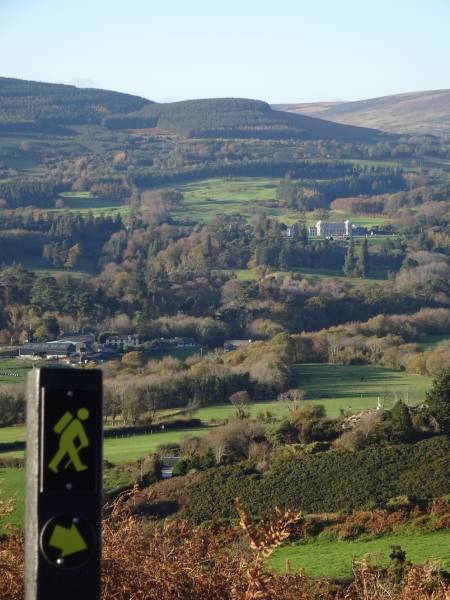
View of Powerscourt from the Sugarloaf way
Start at the junction of Quill road with the R755. Head uphill onto Quill road and after only 25m take a right hand turn onto a narrow tarmac road leading W. Follow the road for 300m as it turns south, until you meet a marker post for the Sugarloaf way. The sign for the Sugarloaf way is a little yellow man with a rucksack and/or a yellow arrow. Turn right here. Follow the tarmac road for another 180m until where there is a fork with a grassy lane to the left with another fork immediately off this again. Take the far left fork which is a grassy lane leading up the hill between two gardens. Please make sure to respect the privacy of the people who live here. Do not park your car here. Keep going up the hill, ignoring some smaller side tracks, for 250m. The lane then goes downhill a bit and meets a gravel road. Turn left here. After only 30m you will meet a junction with a number of gates leading into various properties. The gate for the Sugarloaf way is white and indicated by the yellow arrow. The route you are following it that of the old coach road from Kilmacanogue to Roundwood. It is lovely to see how it snakes between the stone walls and around the hillside. The route continues up the hill to a rusty red gate with a half circle in it. Go through this gate. You are now on a gravel path in between ferns, gorse and rock outcrops. After 700m you will pass two steel barriers to reach an open area behind a lovely row of trees at the end of a field. The path turns left and then right here and continues close to the hill. Ignore a few grassy lanes that lead to and from the fields in the area. After 400m you reach a waymark post for the Sugarloaf way. Turn left here and join a grassy lane for only 10m and leave it again to the right. Continue upwards and at the next marker post, leave the Sugarloaf way and continue straight on up the hill. There are beautiful views here over the valley with the two domed towers of the Powerscourt 18th century house to the NW (not to be confused with the newly built Ritz Carlton hotel to the E of it). Take a left turn here and follow the grassy path further up the hill to a small cairn. Continue S and after 50m you will reach another smaller cairn where the path forks. There is a marker post here with a red arrow on it which points to the S. That route does not go to the top of the Great Sugarloaf. Take a left turn instead and follow this path for 350m in ESE direction. On this side there are nice views over Dublin bay and on a clear day you may be able to see mount Snowdon in Wales to the E which is 130 km from here, but 1080m in height so it can be seen over the earths curvature. When the path forks you can see a zigzag route heading up the Sugarloaf right in front of you. This route involves quite a bit of steep scrambling over loose rock, so it is better to turn right here and take the normal route to the peak. Continue S for 700m until you come to a junction with a rocky track to the left leading straight up to the top of the Great Sugarloaf in E direction. It is only 10 minutes to the top of the Great Sugarloaf from this point. This is the peak requires scrambling over rocks and if you are not comfortable with this you can just continue straight ahead and skip the top. Please remember that scrambling up is always easier than scrambling down and rocks can get very slippery in wet weather. When you are back on the shoulder continue S for 400m to where the path levels out and becomes wide and grassy. There is a wooden marker post here for the Great Sugarloaf way. Turn right at the marker post and follow the path in NW direction for 150m to another marker post at a fork. Turn left here and keep following the yellow arrows for the Great Sugarloaf way all the way back to Kilmacanogue.
Editing Details for track/3695
NOTE: ALL information such as Ascent, Length and Creator time taken etc should be regarded as approximate. The creator's comments are opinions and may not be accurate or still correct.
Your time to complete will depend on the speed of the slowest plus break time and your mode of transport.
NOTE: It is up to you to ensure that your route is appropriate for you and your party to follow bearing in mind all factors such as safety, weather conditions, experience and access permission.
Uploaded on: Tue, 30 Jan 2018 (17:31:30), Linkback: https://mountainviews.ie/track/3695/
* Note: A GPS Height in the elevation profile is sourced from the device that recorded the track. An "SRTM" height is derived from a model of elevations for parts of the earth. More detail
Use of MountainViews is governed by conditions and a privacy policy.
Read general information about the site. Opinions in material here are not necessarily endorsed by MountainViews.
Hillwalking is a risk sport. Information in comments, walks, shared GPS tracks or about starting places may
not be accurate for example as regards safety or access permission. You are responsible for your safety and your permission to walk.
See the credits and list definitions.


 Our Facebook page.