Cookies.
This website uses cookies, which are small text files that the website puts on your device to facilitate operation. Cookies help us provide a better service to you. They are used to track general user traffic information and to help the website function properly.
Features
Nearby features appear when you click the map.
Declutter tracks on map.
Place Search
Video
X
Pub: by
Wexford Area , SW: New Ross Hills  Subarea
Feature count in area: 14, all in Wexford, OSI/LPS Maps: 61, 62, 68, 69, 76, 77, EW-B, EW-B
Highest Place: Slieveboy 420m

Starting Places (16) in area Wexford:
Askamore Cemetery, Ballymore Wood, Clone Strand, Clonegal, Coolmelagh Forest CP, Cummer Wood South, Gibbet Hill West, Mary Neal's Spout, Mount St Benedict's School, R746 Half Way House, Scroughmore Cross W, Slieveboy NE, Slieveboy SE, St John's Church, Tarahill House, Vinegar Hill

Summits & other features in area Wexford:
N: Bunclody: Kilmichael Hill 269.3m
N: Bunclody : Gibbet Hill 315m, Kilcullen Hill 218m, Slieveboy 420m
N: Enniscorthy  : Oulart Hill 179m, Vinegar Hill 116.6m
NE: Wexford East : Carrigroe Hill 232m, Tara Hill 253m
S: Wexford South: Bree Hill 179m, Camaross Hill 181m, Forth Mountain 237m
SW: New Ross Hills : Carrickbyrne Hill 233m, Lacken Hill 193m, Slievecoiltia 268.5m

Note: this list of places may include island features such as summits, but not islands as such.
Rating graphic.
Slievecoiltia, 268.5m Hill Sliabh Coltair A name in Irish,
Place Rating ..
(Ir. Sliabh Coltair [logainm.ie], 'mountain of Coltar'), Wexford County in Leinster province, in Binnion Lists, Slievecoiltia is the 1241th highest place in Ireland. Slievecoiltia is the most westerly summit and also the second most southerly in the Wexford area.
Grid Reference S72794 21327, OS 1:50k mapsheet 76
Place visited by: 65 members, recently by: DeirdreM, AptZeus, markwallace, TommyMc, Jonesykid, ei7kh, GoldCircle, nickywood, Noahq10, FrankMc1964, Roen, Wildrover, Nakoz, Tom98, Gus
I visited this place: NO (You need to be a logged-in member for this.)
Longitude: -6.932739, Latitude: 52.33919, Easting: 272795, Northing: 121328, Prominence: 187.5m,  Isolation: 7.5km, Has trig pillar
ITM: 672727 621379
Bedrock type: Green & grey slate with thin siltstone, (Ballylane Formation)
Notes on name: Coltair is the personal name from which the surname Ó Coltair (Coulter) is derived.
  Short or GPS IDs, 6 char: Slvclt, 10 char: Slvclt

Linkback: https://mountainviews.ie/summit/982/
Gallery for Slievecoiltia (Sliabh Coltair) and surrounds
Summary for Slievecoiltia (Sliabh Coltair): Drive up summit with great views on a good day.
Summary created by simon3, jackill 2014-05-30 09:26:29
            MountainViews.ie picture about Slievecoiltia (<em>Sliabh Coltair</em>)
Picture: Slievecoiltia from the north.
Starting at A (S72900 19400) Slievecoiltia has an access road that leads all the way to a carpark on top.
From the top carpark the summit is a short stroll away across a grassy area.
The summit has excellent 360 degree views with an information board pointing out visible features and a memorial to the pikemen of 1798.
Linkback: mountainviews.ie/summit/982/comment/5741/
Member Comments for Slievecoiltia (Sliabh Coltair)
Comment create / edit display placeholder

            MountainViews.ie picture about Slievecoiltia (<em>Sliabh Coltair</em>)
Picture: Summit of Slievecoiltia with Blackstairs Mountain to the left of the Trig Pillar
wicklore on Slievecoiltia
by wicklore 10 Nov 2009
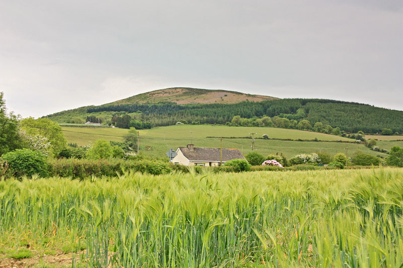
Slievecoiltia is a hill next to the JFK Arboretum in Wexford, and is part of the same overall park. It has an access road that has opening times. Unlike the JFK Arboretum you dont have to pay. The entrance road for the hill is at B (S729 194) (OS Map 76). There are numerous places to park along the 3 km road that leads to the top so its your choice where to start walking. (You can even park at the summit if you want)

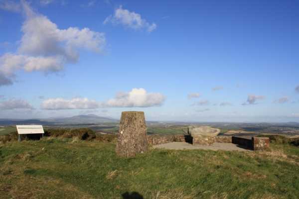
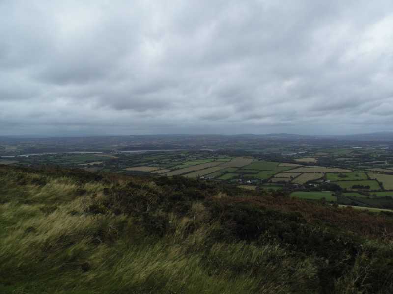
The summit area is a pleasant grassy field next to the car park. Stunning views are available in all directions. As Sunday was a lovely clear day I could see Hook Head Lighthouse, Waterford City, the Comeraghs, the Galtees (85 kms away),Slievenamon, the Blackstairs, Brandon Hill, and a host of minor hills and villages. There were many people about enjoying their Sunday outing and one of them, an elderly man, came over to chat. He must have seen my gps unit as I was busy capturing the summit info for MV. He introduced himself as Danny Burke who used to work for the Ordnance Survey of Ireland. We enjoyed a great chat as he explained about the work he used to do. He told me that in the 1960s he was one of many staff that were sent out to find and rediscover the many hundreds of Trig Points that had been used in the original ordnance survey. He said that these were only clay tablets in the ground and he described the difficulty and adventure in seeking them across the country in often terrible conditions. They then built the modern trig pillars in their place that we see today, which they used for their new survey. Of further interest was that he said the measurements were done at night, with people on each summit using bright helium lights to be visible to other surveyors up to 40 kms away.

I thought this was fascinating stuff and it really brought these anonymous concrete pillars to life for me. I considered some of the trig pillars I had seen buried in forests and gorse that had slipped into obscurity, probably never to be used again. With modern technology they would now be as defunct as the original clay tablets Danny referred to.

The pleasant summit includes a board pointing out the many distant mountains and their names. There is also a 1798 memorial stone at the summit which states: - The rebels camped on Slieve Coillte from the 7th to 10th June. Bagenal Harvey resigned his command here. He was succeeded by Fr Philip Roche. A detachment under the command of Thomas Cloney attacked the gunboats on the river Barrow at Fisherstown. -

This odd, stilted account no doubt refers to a meaningful episode of the 1798 Rebellion, but it could have been expanded to be more informative

Despite the crowds Slievecoiltia is really well worth a visit if you are in the area, but only on a day that allows you to get the most out of the amazing views. Linkback: mountainviews.ie/summit/982/comment/4264/
Read Less
Read More

            MountainViews.ie picture about Slievecoiltia (<em>Sliabh Coltair</em>)
Picture: Peacock pause on descent.
Serial Summiteer!
by paddyhillsbagger 14 Aug 2011
Spotted this brilliant Peacock butterfly flying around the planted oaks off the access road on Slievecoilltia.
Also, in the time my wife and I walked to the top and back, an energetic young man jogged to the top and back 4 times! Linkback: mountainviews.ie/summit/982/comment/6478/
Read Less
Read More

Access Closed During Drought
by TommyMc 22 Jul 2018
The road up Slievecoiltia, from the entrance opposite the JFK arboretum, is currently closed owing to the risk of fire arising from the current dry spell in the South East. Expect this to continue until the rain returns. Linkback: mountainviews.ie/summit/982/comment/19980/
Read Less
Read More

            MountainViews.ie picture about Slievecoiltia (<em>Sliabh Coltair</em>)
Picture: The river Suir winding it's way through the Irish countrside.
She said yes!
by TommyV 4 Nov 2018
Nothing additional to add to simon3's comments. As this hill is the only prominent ground in the area, the views are better than you would expect from such a small hill. As good a place as any to bend the knee. Linkback: mountainviews.ie/summit/982/comment/20188/
Read Less
Read More

Will explore next time.
by Corkonian 22 Apr 2017
There is a drive to the top. Busy place. Good views from the top. Linkback: mountainviews.ie/summit/982/comment/18896/
Read Less
Read More
EDIT Point of Interest
text
Videos
Recent Contributions
x
Conditions and Info
Use of MountainViews is governed by conditions and a privacy policy.
Read general information about the site.
Opinions in material here are not necessarily endorsed by MountainViews.
Hillwalking is a risk sport. Information in comments, walks, shared GPS tracks or about starting places may not be accurate for example as regards safety or access permission. You are responsible for your safety and your permission to walk.
See the credits and list definitions.

OSi logo
OSNI/LPS logo
Open Street Map
(Various variations used.)
British summit data courtesy:
Database of British & Irish Hills